The Woodham Infrastructure Group
Fight the Good Fight with all your Might
WHAT NEXT?
The meeting will be held in the Dame Elizabeth Hall in the William de Ferrers School on the Thursday 24th October. It starts at 7.30 (doors open at 7). Seats will be available on a 'first come, first served' basis.
You can raise whatever topics you like so long as they are relevant to the Town's infrastructure - be they related to public transport, the state of the roads, parking, health and healthcare, education, policing, etc.
The objective is to get a better understanding of what concerns residents and to try to come up with constructive ideas for making improvements.
TO BOOK A SEAT in advance send an email to woodham.infrastructure.group@gmail.com - putting 'MEETING' in the subject line and your name(s) in the body (text box) of the email. If you want to add your phone number or date of birth (in case others have the same name) that's up to you.
FURTHER INFO (the story so far) - https://shorturl.at/l5cos (or https://mega.nz/folder/AmkGiDJb#Uc0jJOLUILG1NN3SISSbGw). Alternatively scan the QR code.
The only thing necessary to ensure bad things happen in SWF is for good folks to do nothing!
SAD NEWS
Alan Brunning, the driving force behind the Infrastructure Group, who worked tirelessly for the benefit of the residents of South Woodham, died recently.
He will be greatly missed!
Our sympathy goes out to his wife, Jennifer, and his family
PREVIOUS ACTION
Just picked up a CCC advert in Friday's (7 June 24) Focus, page 8. It relates to CCC's Local Plan with preferred options consultation and refers to the Land North of South Woodham Ferrers. Proposes 1220 new homes plus a variety of ancillary development. States consultation runs from 8 May to 19 June. Typical CCC - one month of the consultation period is already lost when the advert is published. Effectively it leaves just 12 days to read and consider all the documents (numerous and complex), then prepare and submit any comments.
Suggest (a) respond ASAP and (b) complain about inadequate time to respond in detail.
Many thanks.
ONLINE MEETING TO DISCUSS THE NEW SWF HOUSING DEVELOPMENT
There has been a call for a meeting to discuss the ins and outs of the new development. We thought we'd dip a toe in the water with an initial online meeting on Monday 21st August.
It's being broadcast between 7.30pm and 8.30pm on Facebook (the link is https://tinyurl.com/Woodham-Infrastucture-Group - the typo isn't ours, by the way) and there will be a recording made available afterwards to ameliorate the bitter disappointment felt by those unable to watch the live broadcast.
We are not contesting the housing development itself - just the woefully inadequate plans for infrastructure.
You are welcome to send questions in advance to woodham.infrastructure.group@gmail.com so that we get a feel for the aspects that are of most interest to you.
The Woodham Infrastructure Group.
+++++++++++++++++++
UPDATE: So far the SWF new development proposal has, as expected, followed the pattern dictated by Essex County Council (which stands to make £millions) and Chelmsford City Council. What next? Does Woodham wave the white flag as it has in the past and give everyone the impression it's a soft target, or do we put up a fight?
Judicial Review was mentioned by the Town Council in the scathing criticism of the road transport plan in its excellent Response to Stage 2 of the Disaster-plan.
We think this is worth following up given Bob Massey's view that it will be tantamount to "throwing residents under the bus" if suitable infrastructure improvements aren't made - but the objective must be clear. There would be no point in challenging the housing development itself, even if this battle hadn't already been lost. Housing is needed, although green-field sites should be the last resort rather than the first - as is the case in this area.
What is worth fighting for, however, is significant improvement in the ludicrous, unworkable, cheapskate suggestions for infrastructure. We already have the expert reports needed thanks to your generosity. All that is needed now is a barristers opinion on the likelihood of success.
We've made a start on funding this but, as we're not there yet, we are, therefore, re-opening our old crowd-funding site to raise the balance. The link is https://tinyurl.com/5n9xyndb and the QR code is below. We are entirely dependent on your generosity. Without it, nothing will happen and Woodham will have to live with the consequences for decades to come.
We will also be holding a 'virtual (online) meeting' soon (on Monday 21st - see details above) to see what further steps you want taken and to assess the appetite for a possible real live meeting at a later date. Please send suggestions in advance to woodham.infrastructure.group@gmail.com. Suggestions received so far include petitioning parliament and organising demonstrations (with placards & banners) in SWF re the threatened loss of car parking space and/or in Chelmsford re the impending infrastructure crisis. We'll have a better feel for what is wanted/needed and the likely level of support for this sort of further action after taking soundings.
As ever, thank you for your support.
The Woodham Infrastructure Group.
'Click-on' link: This is the link for the 're-opened' Just Giving crowdfunding site.

MORE News
ALAN BRUNNING HAS POSTED THE FOLLOWING MESSAGE ON THE SWF FACEBOOK PAGE: The New Development. How many people believe that making the B1012 Burnham Road into an Urban Street is going to improve the traffic flow through the town from Burnham? This is what is going to be installed unless we ALL get together and protest. I am not against the homes but am against the lack of a new northern by pass. The existing plan will mean that the majority of traffic will divert using Ferrers Road right through the middle of our town.. It will also mean that the town will be gridlocked during the morning rush from 06:30 to 8:30. THIS HAS ATTRACTED A NUMBER OF COMMENTS, MOSTLY FAVOURABLE and support for his suggestion that a meeting should be held to discuss a strategy.
CENSORSHIP: Unfortunately the Infrastructure Group is barred from the SWF Facebook page (we have applied twice - no response) so, although, it's not ideal, we will make use of the alternatives to deal with the major points.
A good question is: "What is WIG trying to do?" Basically we are trying to improve the infrastructure (the clue is in our name) not stop houses being built (as that would be a Quixotic battle).
Here's the latest social media post which gives more details:
BRIEFLY – there is a potential opportunity to have the recent planning decision Judicially Reviewed with a view to getting the infrastructure plans substantially improved. We are focussing predominantly on the highways implications at present - as you know, these will severely affect the Burnham Rd (B1012) - the main means by which we get in and out of South Woodham. As many of you will also know, the planners and developers have kindly gone out of their way to screw up - thereby providing what appear to be grounds for Judicial Review. The Town Council mentioned Judicial Review its Response to Stage 2 Masterplan Consultation for Site 10 and more recently claimed that traffic documents are “inaccurate, out of date and have no bearing on the local reality of the traffic flows” (according to a local newspaper article: https://www.essexlive.news/news/essex-news/traffic-data-1000-home-south-8098205)
Bob Massey famously said of the infrastructure proposals for the new development: "I think we should take this beyond traffic and include the school and include the flooding. Because if those three areas are not fully covered then I'm afraid you're throwing the residents of South Woodham under the bus." We leave it to you to decide if we are collectively staring up at the integrated chassis of a Routemaster.
Unfortunately 'the legal option' is the only language the planners in this area understand - and it's the only way to deal with hit and run developers who build and then run off with massive profits, leaving local residents and businesses to live with the chaos they cause for decades.
The Infrastructure Group has already obtained legal advice that the Aarhus Convention would almost certainly apply here because of the environmental significance of the planning proposals. This convention, for example, puts a cap on the claimants cost liability at e.g. £5,000 for individuals.
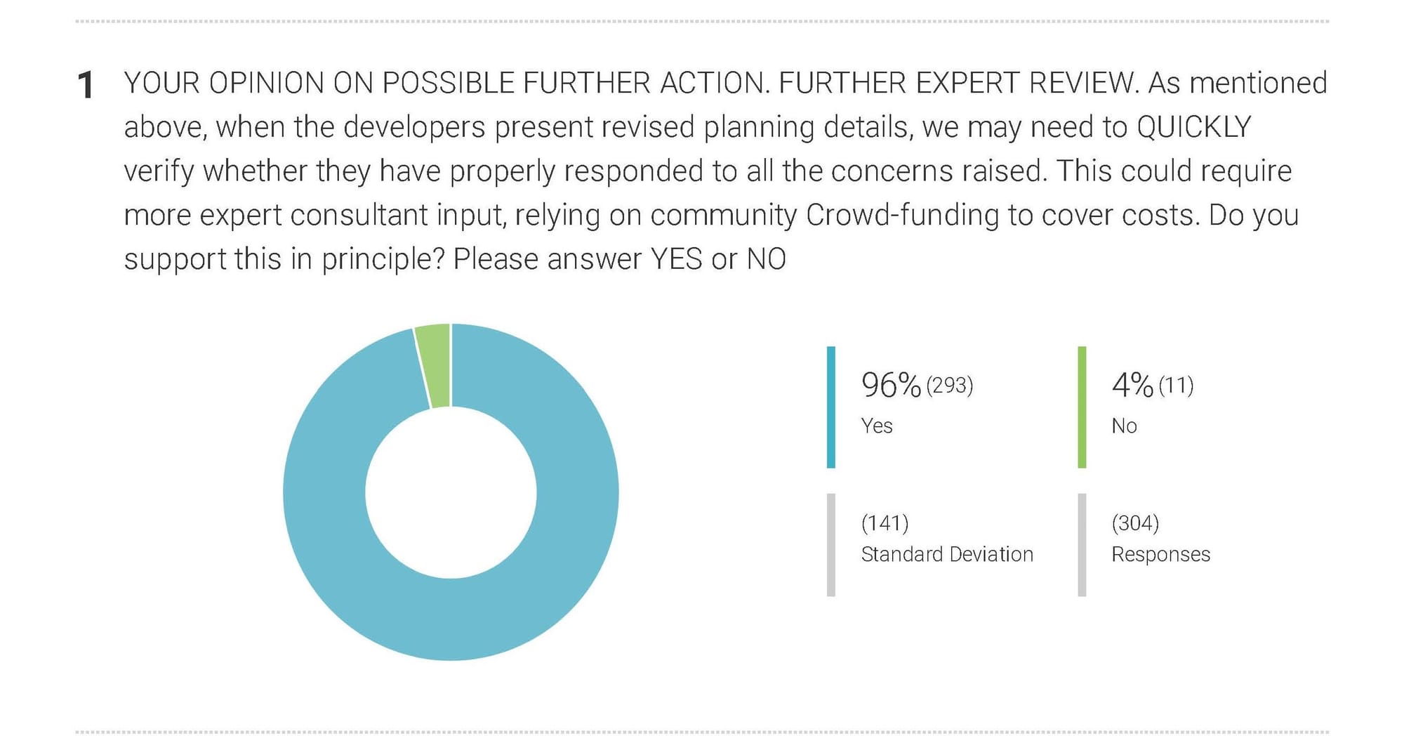
If, as seems likely, we get a favourable opinion, the cost of mounting this challenge can be met by crowd-funding. A recent survey of the public showed strong support for this measure: 95% voted "YES" in South Woodham. In the SWF 'Mini-Survey', 90% of the respondents wanted 'an elected body' to undertake any 'further action' - but we'll cross that bridge when we come to it. We are currently leafleting businesses in SWF. Those that want to contribute can contact us at woodham.infrastructure.group@gmail.com
IT ONLY TAKES ONE SUCCESSFUL JUDICIAL REVIEW TO SET A PRECEDENT THAT WILL BENEFIT THE TOWN AND ITS ENVIRONS FOR DECADES TO COME in that it will bring an end to 'hit and run' raids - because the perpetrators will know that, if there is one success, there will be many more to follow.
With thanks
The Woodham Infrastructure Group
(Aiming to improving the local infrastructure - not stopping house building)

RESULTS OF NEW SURVEYs
Edit your About page from the Pages tab by clicking the edit button.
NEW SWF SURVEY - INTRO
SWF SURVEY - 1
SWF SURVEY - 2
SURVEY - 3

UPDATE - CROWDFUNDING THE FIGHT FOR A FAIR SOLUTION

Recent events have shown that residents are prepared to stand up to those who ignore the views of the residents, particularly with regard to implementing adequate infrastructure improvements. As a direct result of the outcome of the surveys (see above) a crowd-funding platform has been set up to raise funds for an expert opinion on the current problem - plans to downgrade the B1012 (Burnham Rd) to an 'urban Street' with several new impediments (signalised crossings and roundabouts). This is the principle route in and out of The Dengie - and the only way in and out of South Woodham given that the River Crouch and its tributaries make the town a virtual peninsula
This opinion would be a prerequisite for a legal opinion (a 'last resort' option) at a later date if a satisfactory outcome cannot be obtained in any other way.
THANK YOU for contributing to the cost of the first report from an infrastructure/transportation/planning consultant. It was so hard hitting that it has brought about a rethink. Countryside and Essex County Council (ECC) have to prepare a new Traffic Assessment (aka a 'network microsimulation' model.)
Whilst we may have won an important battle , we haven't won the war. The developers have been allowed several months to come up with strategies whereas we will only be allowed 3 weeks from the time the new documents are released to submit a riposte. We therefore have to be ready to hit the ground running. As always with these Traffic Assessments it is a case of 'garbage in/garbage out' - but the realisation that any model that is prepared by the developers will be subject to peer scrutiny by our consultant, means we have reduced its ability to be too liberal with the inputs - or, to put it another way, too economical with the truth.
We have, therefore, had another meeting with our consultant to ensure he is ready to react instantly when the new documentation is released.
As you know there has been a gradual increase in the number of houses to be built north of the Burnham Rd meaning, of course, that there will be greater demands on the town's infrastructure. There is now also the prospect that the land east of and immediately adjoining the Masterplan site will be developed with up to a further 1500 homes - and this will virtually join SWF to Stow Maries. These fields were previously used for the Brownstock Festival and Boot Sales and have been given the green light in Maldon District Council’s (MDC's) call for land. If this scheme is eventually approved there is potential for a total of 3000 new dwellings next to the Burnham Road (B1012) with all the infrastructure implications for a development of that scale.
There are also several new developments in Dengie which are currently in the pipeline - and these in their totality will place enormous pressures on the creaking infrastructure.
Healthcare, Education, Drainage and particularly Highways and Transport will all be affected. A report on Look East last week made it clear that part of the healthcare problem in Essex has been the result of the unprecedented level of building here without concomitant improvements and expansion of NHS provision. Moreover, the roads approaching SWF from the east and west are already very busy and have a poor accident records. The planner’s current proposals will cause gridlock and markedly increase pollution in and around SWF during peak hours. Unfortunately, human nature dictates that once they’ve escaped the logjam many drivers will speed up to get to work on time or avoid arriving home later than expected. This can only exacerbate the current situation on the roads in the area and increase the number of serious collisions. To date, the planners have managed to turn a blind eye to all infrastructure implications for residents in the area.
We think the three local authorities, ECC, CCC and MDC, should start talking to each other. Whilst acknowledging the need for new housing, whatever final number is approved, whether it be 1000 or 3000, a bit of joined up thinking is needed in order to provide the necessary infrastructure for the totality of the development (as opposed to considering each application independently.) With regard to highways we are asking that there should at least be an adequate alternative to replace the current by pass that will be turned into an urban street running through a residential area and past a primary school.
ORIGINAL REPORT FROM OUR CONSULTANT - SUMMARY
OBJECTION TO PLANNING APPLICATION 21/01961/OUT
PROPOSED RESIDENTIAL DEVELOPMENT OF UP TO 1,200 HOMES, 88 BEDROOM UNITS OF RESIDENTIAL CARE USE, NEIGHBOURHOOD CENTRE, COMMUNITY CENTRE, BUSINESS FLOORSPACE, PRIMARY SCHOOL AND 5 SERVICED PLOTS FOR TRAVELLING SHOW PEOPLE
Specialist Transport Planning consultants SCP have been instructed by South Woodham Ferrers Infrastructure Group to review and advise on the transport Impacts of the above planning application. We have reviewed the plans, Design and Access Statement and in particular the Transport Assessment undertaken by Mayer Brown, attached to this letter is a report of our findings.
In line with NPPF paragraph 111, we believe that the planning application as submitted should be refused on highway and transport grounds. In summary this is because:
• The Transport Assessment has not modelled the junctions correctly or considered the effect of one junction on another. In particular:
- The base flow models are not calibrated against observed traffic queues, in most cases the junction models understate the queue and delay at each junction.
- The junction models do not correctly model HGV traffic, this is shown by the error messages in the model outputs. This means the results understate the junction performance. This is especially material here as HGV flows are up to 17%, which is very high compared to many roads.
- No account is taken of committed developments which will add traffic to the base network. PPG “Travel Plans, Transport Assessments and Statements” makes clear such developments should be considered. This means the future year scenario is modelled without the known additional traffic from these sites.
- 2026 is assessed as the future year scenario. This is unrealistic, given the need to secure Reserved Matter consent and taking account of typical house builder build rates, 2035 is a more realistic future year. Again, this is contrary to the advice set out in the aforementioned PPG.
- It is also important to understand the interaction between the assorted junctions and crossings, only the junctions have been considered and these have been assessed in isolation, a calibrated micro-simulation model is required to assess the cumulative effect of traffic on the local network. The consequence of the above modelling deficiencies is that the impact of the traffic generated by the development are materially underestimated and the impact will be materially greater. Without a robust assessment and proper and planned mitigation put in place the traffic generated by the development will have a severe impact on the local highway network, result in drivers taking excess risk at junctions and cause pollution. This is contrary to paragraph 111 of NPPF.
• Great play is made of the location of the site and access to the local railway station and facilities, suggesting people will choose to walk rather than drive. The measurements quoted are from the site access point rather than the furthest dwelling or at the very least a mid-point location. This means that overly optimistic assumptions are being made with regard to modal choice. Therefore, without further demonstration that the site is genuinely accessible on foot and by bike the site fails the test set out in paragraphs 110 and 112 of the NPPF.
As currently submitted SCP believe there are sufficient grounds to refuse the application on highways safety grounds and due to the likely severe impact the extra traffic will have on the transport network in terms of capacity and congestion. Having regard to paragraphs 110 and 111 of the NPPF the inadequate nature of the submitted proposals and the likely severe residual impact which will result even with the mitigation measures outlined, are not deemed to be sufficient to prevent a severe residual adverse cumulative impact.
Therefore, we request that this application is refused or, significant additional Transport Assessment work is undertaken which address the above points and bring forward a long term mitigation plan that properly addresses the impact of the traffic expected to be generated.
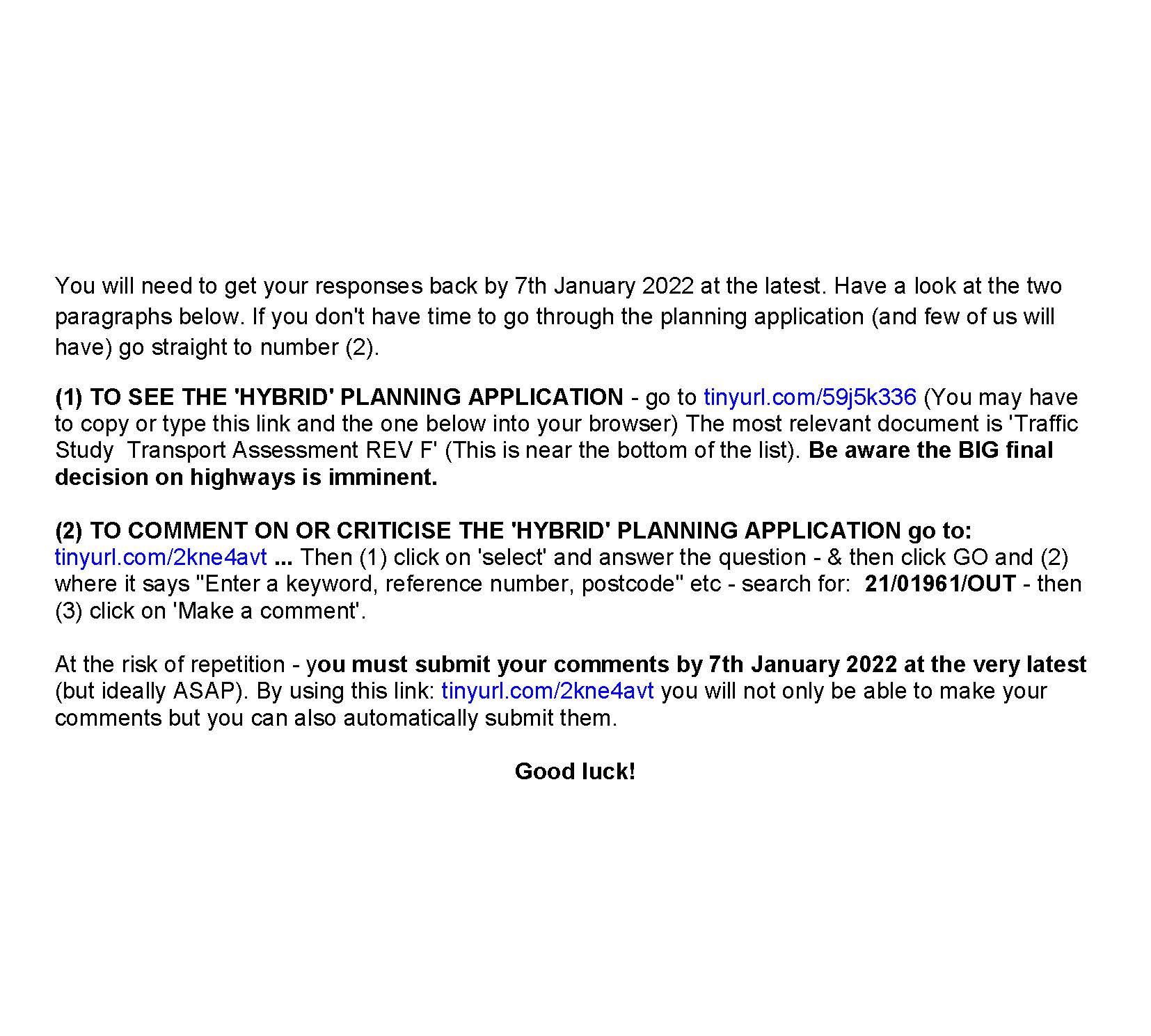
HOW TO RESPOND TO THE ORIGINAL PLANNING APPLICATION
(ADVICE ON RESPONDING THE THE CURRENT/REVISED PLANNING APPLICATION - To submit your response use this link: https://tinyurl.com/4j82yx74 ... and enter 21/01962/out ) The deadline is December 10th 2022 )
There are some detailed (and somewhat complicated) directions on how to comment on or criticise the 'hybrid' planning application below. The simplest way, however, is to concentrate on the comments made (above) by the Specialist Transport Planning consultant as anything other than these is unlikely to be listened to when it comes to the important planning decision. A single sentence or paragraph is FAR better than not making any comment at all. Those who fail to comment are playing into the hands of the developers.
To comment paste this into your browser: tinyurl.com/2kne4avt ... Then (1) click on 'select' and answer the question - & then click GO and (2) where it says "Enter a keyword, reference number, postcode" etc - search for: 21/01961/OUT - then (3) click on 'Make a comment'. (Alternatively go to QR code no 3 (below). You must submit your comments by 7th January 2022 at the very latest (but ideally ASAP).
MISTAKES IN PLANNING APPLICATION
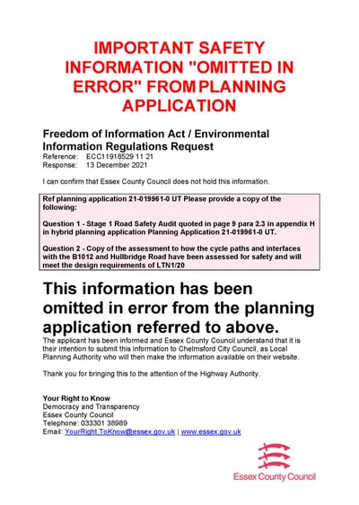
The documents in this planning application (and there are over 100 of them) are badly assembled, riddled with errors, and impenetrable. The uncharitable might take the view that the objective was to conceal rather than to reveal - i.e. to make it next to impossible for the average resident to read and understand the application.
THE APPLICANTS EVEN FORGOT TO INCLUDE THE STAGE 1 ROAD SAFETY IN THE ORIGINAL SUBMISSION AND HAD TO INCLUDE A MAJOR REVISION TO APPENDIX A DURING THE CONSULTATION PERIOD.
It rather looks as if whoever was responsible has never visited South Woodham - for example they think we have an "Oaklands" railway station!
2021 SURVEY - EXPLANATION
The results are presented as graphs (below). Click on each image to enlarge it.
There were 307 responses to this survey which focussed on the opinions of the residents and businesses in South Woodham Ferrers - an excellent result for this area.
The view of the public does not appear to have changed materially since the last survey was done in 2020 - the results of which also appear 'further down' the website
This is about infrastructure - we are not campaigning against the new development in SWF. We recognise the need for new houses - although, for the sake of wildlife and the good of the planet, we go along with the PM's conference speech in which he said that he wanted to build the homes the country needs “not on green fields” whenever it is reasonable & practical to do so.
Many of the questions in this survey were about a particular situation which will adversely affect South Woodham Ferrers and the Dengie - but most of the questions and answers have Essex wide implications.
The planners and developers have been given a clear steer on what people want. If they don't like the results of our 'on a shoestring' survey they can conduct their own.
Whilst this survey was aimed at a small geographical area and a particular set of circumstances the findings have Essex wide implications.


2021 SURVEY RESULTS - DECEMBER 2021


MIKE BENNING COMMENTS ON SURVEY RESULTS
HOW TO RESPOND TO THE ORIGILAL PLANNING APPLICATION


PREVIOUS NEWS & UPDATES
UPDATE (OCTOBER 2021)
NEW PODCAST - will the infrastructure of the town be improved sufficiently to cope with the new development? Or will the residents (in the words of the former Mayor) be "thrown under the bus"?
This is a whistle-stop tour of how we got to where we are today - and where we go from here. It's a podcast (sound recording) so it brings a somewhat dry (but supremely important) subject to life far better than any amount of text.
Have a listen while you are driving or ironing (but hopefully not doing both at once) ... or jogging or cleaning the car or fixing the tap that keeps dripping or travelling on the bus or train. DON'T listen to it just before you go to bed, however, as you'll be so excited that you won't get a wink of sleep!
There are important decisions ahead for the town - but that doesn't mean the podcast has to be all doom and gloom - and nor does it mean that it can't present more than one side.
When you've had a listen - pass the link on.
LINK: https://www.podomatic.com/podcasts/woodham-infrastructure-group/episodes/2021-10-11T13_53_22-07_00
+++++++
Are we about to be 'thrown under a bus'?
The new development North of the Burnham Road will take place. It would be pointless to pretend otherwise. However, the Woodham Infrastructure Group and many others believe the proposal to urbanise the Burnham Road, adding a cross roads, more traffic lights and pedestrian crossings will create significant congestion, encouraging through traffic, cars/HGV’s, to use Ferrers Road as a rat run. The scheme has the potential to ‘lock in’ the 8000 residents south of Ferrers road at peak time. As Cllr B Massey put it, we will be "thrown under the bus.'
This map shows the nine crossings proposed in Countryside masterplan

As the 'Woodham Infrastructure Group' our prime objective is to ensure that highway decisions associated with this development are not detrimental to our town and those who live on the Dengie by providing ‘improvements to the local and strategic road network as required by the Local Highways Authority’ and that the development will meet the Chelmsford Planning Policy DM30. (Chelmsford Local Plan 27th May 2020 pages 168 and 237 development will not have an unacceptable impact on air quality and the health and wellbeing of people
The link is: https://www.chelmsford.gov.uk/planning-and-building-control/planning-policy-and-local-plan/adopted-local-plan/
Downgrading the Burnham Road (B1012) and the Bicknacre road (B1418) to urban streets. The Local Plan & 'Master Plan' and the recent newsletter from Countryside Properties show at least 9 pedestrian crossings, a new roundabout - and cross roads with traffic lights to replace the existing Old Wickford Road roundabout (B1012/ B1418 intersection www.countryside-swf.co.uk (slide 8).
Essex Highways and Countryside maintain these changes will improve traffic flow on the Burnham Road. SWF Town Council supports the scheme stating "Your Town Council supported the downgrading of the Burnham Road to a 40mph one” as seen p 55-57 in the June/ July 2020 pre submission version of the Neighbourhood Plan (see below). It adds: ‘Creation of a new northern by-pass, redirecting east west traffic. Such an approach would be very expensive and, given the topography and wider landscape constraints, would result in a significant diversion and added cost implications. Although this remains the Town Council’s preferred option, it was ruled out through the Local Plan’. The text and plan were removed from the July 21 version prior to the vote.
https://www.southwoodhamferrerstc.gov.uk/Neighbourhood_Plan_26846.aspx
This map shows our suggested route for a northern by pass

The Rat Run Our former Mayor Bob Massey stated, "We need to consider the danger of the rat-run”. As Councillor Roberts suggested, “if the quickest route is to take the Ferrers Rd round the centre of the town, that will cause a lot of danger to a lot of people."
On 23 March 2021 CCC and Essex Highways declared: "There is no plan to re-route traffic along Ferrers Road by a change to signage, …… However, Ferrers Road is classified as PR2, a local distributor road, which is a multipurpose through route with no frontages. Therefore, if traffic chooses to route this way instead of along B1012 it cannot be legally restricted." If Ferrers Road becomes the major route though the town, by default, the 8,000 people who live to the south of this road would be locked in at peak times. There are only official 2 crossings for them to access the same facilities needed by the 4,000 new residents to the north who, we are told, need at least 7.
Why no Northern By Pass Chelmsford City Council (CCC)/Essex County Council (ECC)/ Essex Highways and the Developer have dismissed a northern bypass because of:
Cost A letter dated 26/4/2018 from the then leader of CCC; Councillor R Whitehead to our MP mentions a possible "road to the north of the site" but says "this would be very expensive" and, moreover "it would use up a lot of the proposed site, making it unattractive to purchasers. "
Environmental 3 March 2021 CCC cabinet reply; It was considered that the harm of providing a new road to the north of development on the wildlife site, biodiversity and landscape, would be unlikely to outweigh the benefits to traffic flows on other roads. We would respectfully point out that, if harm to "the wildlife site, biodiversity and landscape" are their primary concerns, leaving the site as it is now is far the best option - so maybe, in future, 'Countryside' and other developers should look at brown-field sites for the affordable housing that is desperately needed. Given that the decision has already been made to build houses here, it is imperative that the necessary infrastructure is provided - a consideration that should be at the heart of each and every planning decision. Sadly, in this part of the world, the planners work on a 'cross your fingers and hope for the best' basis.
The physical barrier provided by a northern bypass would restrict current and future development by Countryside Properties. The by-pass would have to be built on the higher ground below the ‘green necklace’(see above), restricting the number of low density high value homes and preventing urban sprawl
Woodham Infrastructure Group
UPDATE (10th MAY 2021)
UPDATE on POLLUTION: A 2019 Department of Transport traffic survey on the A132 showed it carries TWICE as much traffic as the A414 through Danbury - and the A414 was declared an 'air quality management area' in October 2018. As post Covid lockdown traffic returns, long Wickford bound queues are being seen at Sainsbury’s. Residents close to the Ferrers Rd and King Edwards Rd watch out for ‘Rat Running’
Dates and details of key meetings etc in 2021
Chelmsford Policy Board Meeting Date 14/01/2021 Recording (video): https://www.facebook.com/ChelmsCouncil/videos/386770702623144/
Minutes: https://www.chelmsford.gov.uk/_resources/assets/inline/full/0/4815947.pdf
Masterplan submission for Strategic Growth Site 10: North of South Woodham Ferrers Link: https://www.chelmsford.gov.uk/planning-and-building-control/masterplans-for-new-developments-in-chelmsford/masterplan-submission-for-strategic-growth-site-10-north-of-south-woodham-ferrers-approved/
CCC Cabinet meeting on 2nd March 2021 Video: https://www.facebook.com/ChelmsCouncil/videos/252720669773855/%20Draft
Minutes : https://www.chelmsford.gov.uk/_resources/assets/inline/full/0/5291549.pdf
UPDATE (1st JAN 2021)
There is a NEW VIDEO which emphasises another aspect of the highways situation - see below.
Video dealing with existing 'additional' roundabout - and with environmental (pollution) issues Title: The Tragic Roundabout https://vimeo.com/495971312
FURTHER VIDEO PROG: There is also a somewhat tedious (but instructive) video showing what happens when a small country road is used as a 'rat run' when the principle route (B1012) is partially or completely obstructed.
The title is The Edwin's Hall Road Saga and it can be found at: https://vimeo.com/470541365
UPDATE (9-Dec-20)
Mike Benning provides a brief update on the 'highways' situation in the lead up to the important 'decision making' meeting on 14th January - Link to video update - https://vimeo.com/488547633
Incidentally, there are comments relating to the highways situation on the Neighbourhood Plan website. The link is https://consult.chelmsford.gov.uk/portal/neighbourhood_planning/swf_reg_16/swf_reg_16 Click on 'All Comments.'
There are also comments about another aspect of the town's infrastructure ... healthcare e.g.:
Mr Danny Claridge: I can find no provision in the plan for extra health care facilities, already the new medical centre is showing it is inadequate to handle the current population, both logistically to reach for many and parking spaces insufficient for those that can get there. A restoration of some health facilities to the town centre should be conditional on any further development.
Dr John Cormack There are mentions of health - but very little mention of healthcare. Neighbourhood plans produced elsewhere now also encompass healthcare - see: 'Neighbourhood Plan - Infrastructure Group Response' https://www.dropbox.com/sh/97erekewuxxw0y7/AAA6NnZECgwChHYzt1f2QwlTa?dl=0
This is of particular importance in South Woodham as the town was built without any plans for provision of primary healthcare and this has remained the 'Cinderella service.'
Alan Harper - Another worry is medical facilities.
THIS IS OUR UPDATE ON A RECENT TOWN COUNCIL MEETING DURING WHICH INFRASTRUCTURE ISSUES ETC WERE DISCUSSED WITH THE DEVELOPERS AND OTHER RELEVANT PARTIES.
INFRASTRUCTURE PROGRESS REPORT
We were invited to participate in a meeting between the Town Council and the Developers. There was an initial presentation during which we were regaled with the usual twaddle about sustainability, motherhood and apple pie. We were told that there would be one new tree for every resident - and were shown visuals depicting greenery and happy smiling faces. They talked about high-quality pedestrian and cycle ways - “over 10 kilometres" of them seemingly - and said there would be improvements to public transport.
There was no clear sign of a proposal for a northern ring road. The crossings and roundabouts planned for the Burnham Road remain.
We thought the counsellors present acquitted themselves very well in that they said what we (and you) would have said had we been in their place.
The developers seemed to be rowing back on the number of houses that will be built. At one time it was rumoured there would be as many as 1600. Jacky Birch asked for confirmation that 1200 houses was the TOTAL allocation. This was given. She mentioned that several of the SWF roads are already over capacity, made it clear that traffic is one of the main problems and emphasised that the council have not yet been shown the traffic survey done in February. She said: “We get gridlock now – we are going to be stationary!" It was pointed out (yet again) that traffic volume surveys done so far had NOT been done during 'rush hour'.
Alan Sherring told the developers that they had only played with the problem and hadn’t addressed the fundamentals. He said that the residents have no confidence in the plans for the roads and the counsellors are also concerned. He reminded the developers that “when it goes pear shaped you won’t be around."
The developers returned to their theme and told us that, as well as more bike and pedestrian movements, there will be more public transport and (cheerfully ignoring the likelihood that most of the families living in the new houses will have more than one car) they confidently predicted there will be less vehicles on the road. They said they plan to “change people's travel behaviour" and to that end they will “incentivise people to travel by other means" ... worthy aims but are they realistic?
We were told that Countryside has an "excellent relationship" with bus companies.
A.S. injected a touch of reality by pointing out the major deficiencies in public transport in SWF and said that Council representatives had found it very heavy going whenever they tried to press for improvements.
Murrough O’Brien, who chaired the meeting pointed out that South Woodham is unique –unlike Chelmsford where there are numerous escape routes. Here the access and egress routes are limited. He mentioned that there is no direct bus service to Southend, Maldon or Broomfield (all of which have hospitals). He said that, at one time, somebody found it was quicker to get to the Royal Free Hospital, London, for a morning MRI scan then it was to get to Broomfield hospital.
He mentioned concerns about the 'surface crossings' on the Burnham Rd – at peak times large numbers of schoolchildren (many with bikes) will be travelling to & from the Willy D school – and he feels the Master Plan should include something safer and more practical.
A gentleman from the Dark Side who had previously given the impression that he thought the entire highways problem could be sorted out by reconfiguring the roundabouts countered by saying that the difficulty with underpasses is "where are you come out on the other side". He seemed to think that the existing crossings can somehow be turned into a satisfactory solution and said that they will submit a transport assessment. Having waffled on for a time he said “I don’t think (traffic) surveys mean terribly much” and claimed that his traffic assessment will “provide context."
MB delivered a last kick in the goolies. He said we need to see the evidence base NOW as the council has been shown the evidence far too late thus far. He also pointed out that what evidence there is does not include data about Maldon and Bradwell - and traffic from Maldon district developments.
Our impression is that the developers' hidden agenda is to do everything possible to create smokescreens and avoid addressing the real problems.
So what next? The Town Council needs to come up with a firm plan for the Burnham Rd predicament and ideally (if time allows) run it past the residents as this will strengthen their case. It is blindingly obvious that the present plan for the Burnham Rd is going to create major problems for drivers from SWF and much of the Dengie but the difficulty is making the point forcefully enough to make the decision makers take notice.
We are, meanwhile, liaising with all the local Parish Councils (some of which are VERY proactive/supportive) as well as the Maldon Council and CCC on the basis that there's strength in numbers. The survey results (confirming overwhelming opposition to the existing plan for the roads) has been very well received. If everyone pulls together there's a good chance of victory.
Woodham Infrastructure Group
For those who want further information, The Town Council will presumably be publishing the minutes in due course on its website.
SHORT VIDEO UPDATE - 2020

About Us
Starting in a small way, we hope to change all that.
We will concentrate on one aspect of the infrastructure on which there is agreement . The Burnham Road - the main artery supplying the Dengie - will grind to a halt during busy times if the day (and South Woodham will be gridlocked) unless a sensible solution is found to the problem that faces us: how to improve the roads to enable them to cope with the additional traffic generated bu new housing developments and the construction of the Bradwell B power station.
For more information, read on ...
The Situation
There are to be new housing developments in Maldon, South Woodham and the Dengie and, in all likelihood, a new PowerStation: Bradwell B.
This will generate a great deal of traffic both during the building phase and thereafter. It has been estimated that some 500-700 HGVs servicing the Bradwell B site alone will negotiate the Burnham Road each day.
The pinch point is the Burnham Road as it passes on what is currently the northern border of South Woodham (although it will shortly bisect the town when the new development is completed.) It is already groaning under the strain and there are often tailbacks at the busiest times. There are no plans to widen the road or create a bypass to deal the with additional traffic. All the bypasses currently mooted stop at the Maldon district border leaving SWF out completely. The Bradwell B team acknowledges that Latchingdon, Mayland etc need bypasses but the common exit (the pinch point leading to the A12) has been ignored. To make matters worse, Essex proposes to set up 6 uncoordinated pedestrian crossings along this section of the Burnham Road to link the new South Woodham development to the existing town and claims that this will have no adverse effect on traffic flow
One glance at a map is enough to demonstrate the problem this will cause, not only to South Woodham residents, but to all those living in or near the route from Bradwell B to the Rettendon Turnpike who have to commute by road.
If you want more information, read on. Included are some articles that have appeared in local newspapers, responses to the public enquiry and a response from an elected body (in which the relevant sections have been highlighted)
FORMER CROWDFUNDING APPEAL
WE HAVE HIT OUR TARGET NOW - MANY THANKS - UPDATE TO FOLLOW.
YOUR HELP IS NEEDED TO RAISE FUNDS TO FIGHT FOR A FAIR INFRASTRUCTURE DEAL FOR SOUTH WOODHAM FERRERS AND THE DENGIE PENINSULA
TO DONATE go to: https://www.justgiving.com/fundraising/support-w-i-g
or scroll down to QR code - or simply take your donation to Mr Gee's Charity shop
TO LEARN MORE: - read on
The Woodham Infrastructure Group was set up to ensure that the infrastructure keeps up with the new developments in South Woodham Ferrers & The Dengie. The main threat is that the road that gives access to both (Burnham Rd/B1012) is already groaning under the strain - and things will get MUCH worse as a result of new development in SWF and The Dengie.
STORY: There are planned new housing developments in South Woodham Ferrers and out on The Dengie peninsula. However instead of widening the road or building a bypass the proposal is to place obstructions along the existing road (B1012) in the form of pedestrian crossings and roundabouts between the B1012/Ferrers Road roundabout and Willow Grove (by the BP Garage).
Any driver who regularly uses the Burnham Road from South Woodham Ferrers to the Rettendon Turnpike (A132) during the morning peak period will know just how difficult it is to join it from Ferrers Road, Hamberts Road or Hullbridge Road. The current proposals will likely result in Ferrers Road becoming a “Rat run” through the centre of South Woodham as drivers from North Fambridge and beyond try to avoid this section. This will add to the current queues and is predicted to substantially increase the town’s traffic pollution, reduce air quality and thus affect schools and residences for the elderly.
Without outside pressure from everybody impacted by this decision Essex County Council is expected to pass the much criticised plans for the local highways. After all, it stands to profit substantially from the new development (see article in the 10 Feb Advertiser - https://www.yellowad.co.uk/county-council-would-seek-guarantees-over-a-south-woodham[1]ferrers-housing-development/ ) seemingly more so if the necessary infrastructure improvements are ignored - so there is clearly a conflict of interests.
Since all previous representations pointing out the deficiencies in the proposed plans have been totally disregarded by the decision-makers in Chelmsford, the Infrastructure Group is left with no viable option other than to seek professional advice in order to take this further and is asking for your help. Encouraged by the fact that serious errors (including the withholding of important data) appear to have been made by those responsible for the project thus far, an appeal has been set up to provide the necessary funds to obtain advice on the present position and to commission a report from a specialist transportation planning/highway and infrastructure consultancy as a first step in the process. This will help us and those representing the areas that will be adversely affected including the Town and Parish Councils (which, as we say, have already raised objections which have been ignored) to argue our case more strongly.
We are attempting to raise six thousand two hundred and fifty pounds in order to obtain professional advice and commission an independent report from a specialist transportation planning/highway and infrastructure consultancy. If every household gives just £1 (i.e. less than a cup of Costa coffee or a single KFC chicken piece) we'll have more than enough to take the fight forward - and bear in mind that this is far less than the cost of the extra fuel that will be wasted each year by drivers trying to join the Burnham Road from the town (or to get past SWF from the Dengie) if the Ferrers Road becomes a "rat run", as it surely will without a viable ring road. We ask those who can afford more to do so as to compensate for those who have been hit hard by the pandemic. We also ask businesses which are dependent on traffic flowing freely (and for which the proposals in their present form could have hefty financial implications) to donate larger sums in order to reflect this.
An account of the funds raised and outgoings will be published - all proceeds will go towards obtaining professional advice, raising awareness, and obtaining a fair and satisfactory solution for SWF and The Dengie. None of those involved in the organisation of this initiative will be claiming any fees or personal expenses (i.e. they will be giving their time free of charge.) Apart from the usual card processing charges made by Just Giving there will be no further expenses deducted from your donation by the crowd-funding site.
There may be technical glitches with the Crowd-funding appeal - teething problems, given that, as far as we know, this is the first time this sort of thing has been tried in this area. Rest assured, however, that this will not affect your donation which will be put to good use!
Mister Gees Foundation, a UK Registered charity based in South Woodham Ferrers (which has an excellent reputation for probity and has supported numerous local good causes) has kindly offered to provide a platform for handling donations via Just Giving. In the unlikely event that there is anything left over when all the bills have been settled any surplus moneys raised will be used by the charity to support local causes.
PLEASE HELP US TO MAKE YOUR VOICE HEARD BY SUPPORTING THE INFRASTRUCTURE GROUP AND ITS APPEAL.
TO DONATE go to: https://www.justgiving.com/fundraising/support-w-i-g

2020 SURVEY RESULTS


EXPLANATION of RESULTS OF THE SURVEY

Explanation
Here are the results of the survey which sought your views on the Masterplan proposals for the part of the Burham Rd which currently runs along the northern perimeter of the town (and will bisect the town when the new development is complete). You will recall that the proposal by Essex Highways is to install additional roundabouts and half a dozen pedestrian crossings which, its representatives claim, will not slow the traffic.
These are presented as follows:
1) Survey Monkey (online) survey results. There were a ttal of 721 responses. The analysis of the results show how many people answered each question.
We tried to get as many as possible to complete the online survey (as this did all the work for us) but we did have a 'pen and paper' variety for those who, for whatever reason, couldn't complete the 'Survey Monkey' version.
2) 35 responses were submitted on paper: these showed much the same result - with 100% believing the current proposals will lead to severe traffic congestion.
As you can see the results of the survey are conclusive – there is general agreement that the plans for the Burnham Road are disastrous and those concerned with ensuring that our roadways are fit for purpose need to go back to the drawing board.
We will be communicating the results to all concerned in the hope that common sense will prevail and a solution which is in everybody’s best interests can be found.
South Woodham town council is, as you know, trying to find a satisfactory solution and has asked the public to submit suggestions. This can be done by contacting the clerk at karen@southwoodhamferrerstc.gov.uk or, better still, by responding to the request for comments on the draft neighbourhood plan by 4pm on Thursday 12 November 2020. which can be found by clicking on the link or typing it into your Browser: You only need to review the submission version - see link below.
https://consult.chelmsford.gov.uk/portal/neighbourhood_planning/swf_reg_16/swf_reg_16
Although using the neighbourhood plan website is the strongly recommended method, we're told it's very clunky and difficult to use. Try it, though ... and see if you fare better than we did.
What we're up to at the moment: We have been in touch with the Parish Council is for the areas which will be adversely affected by the current plans for the Burnham Road – and the Stowe Maries and Cold Norton Parish Councils are both extremely concerned and making representations. We understand that Maldon District Council is responding likewise.
We will be doing our best to get all those concerned working harmoniously together and to feed in ideas. Watch this space for further developments.
Our thanks to all those who completed the survey – the default position is for people who will be adversely affected to grumble amongst themselves ... which is all very well but doesn’t achieve anything. What those of you who have completed the survey have done, however, puts pressure on those who, by ignoring the views of the residents, seek to create a catastrophic situation.
We’ll keep you informed of developments.
Woodham Infrastructure Group.
What you can do about the survey
If you have any time/energy left over after commenting on the draft neighbourhood plan and/or letting the Town Council know your views it would be helpful if you could help spread the word by communicating your views on the survey briefly to one or two of the following. When you do so, please tell them they can find the results of the survey at https://www.w-i-g.co.uk/
Maldon and Burnham Standard - News Editor: Chris Wilkin: email chris.wilkin@newsquest.co.uk
Essex Live - www.essexlive.news - Please contact Julia Brigui at communitynews@essexchronicle.co.uk
Essex Chronicle - contact Head of Print Simon Murfitt at simon.murfitt@reachplc.com or Reporter Hannah Brown at hannah.brown@reachplc.com
Chelmsford Weekly News - Email us: cwnnews@newsquest.co.uk
BBC Essex - essex@bbc.co.uk
BBC Look East: look.east@bbc.co.uk
Anglia news: anglianews@itv.com
Heart Radio: east.news@global.com
And don't forget ... the SWF Facebook page and the Over to You page at Focus (Contact: The Editor - wendy@focuspp.com )
Thank you!
NEW VIDEO PROGRAMME - THE TRAGIC ROUNDABOUT
THE TRAGIC ROUNDABOUT
South Woodham's Tragic Roundabout (otherwise known as the Sainsbury's Roundabout) has been given the thumbs down. It fails on several counts - not least among which are fears that it isn't safe.
Here's a short video that sets out the issues. The link is https://vimeo.com/495971312
The significance of all this is that the people who are responsible for these matters continue to argue that the Sainsbury's roundabout is absolutely fine ... and these are the same people who say the rest of the plans for the Burnham Road are absolutely fine too ... so this is a taste of things to come.
The concern is that the volume of traffic on the Burnham Road (which is already struggling to cope)will increase dramatically as a result of the housing developments here and elsewhere and an inevitable effect of this will be a rise in pollution. This increase in the level of pollution will be exacerbated by the stop/start effect caused by the additional roundabouts and the six pedestrian crossings that are planned. There is also a possibility of a new Power Station (Bradwell B) -and , if it goes ahead, it will have a significant detrimental effect.
Another factor is that the Burnham road currently skirts the northern border of the town - but the plan is that it will bisect town in future thereby potentially exposing more residents to pollution AND there is the likelihood of far more traffic (yet more pollution) on the Ferrers Road as drivers try to find a way past the hold-ups on the Burham Rd.
We maintain that there is a clear need for a bypass to allow the traffic to flow freely and to reduce the pollution level experienced by the residents in general and schoolchildren in particular. Unfortunately the decision-makers appear to be more keen on pleasing the developers than they are on finding a solution that works well for everyone and protecting the health and wellbeing of the residents. The pandemic is on their side - because we are focussed on this at present, there could be less of a protest than there would otherwise be ... and it's up to us not to let this happen.
If you have concerns you will need to do something constructive to effect change. Sit back and do nothing and you'll be stuck with 'pig's ear' solution that will have an adverse effect on the residents of the town and commuters from the Dengie for decades to come.
Suggestions for action are contained in the video and on the website: www.w-i-g.co.uk. You'll need to be quick - the meeting at which major decisions will be made is scheduled for January 14th.
Please pass this on to friends, neighbours, family - and anyone else who will be adversely affected by the proposals.
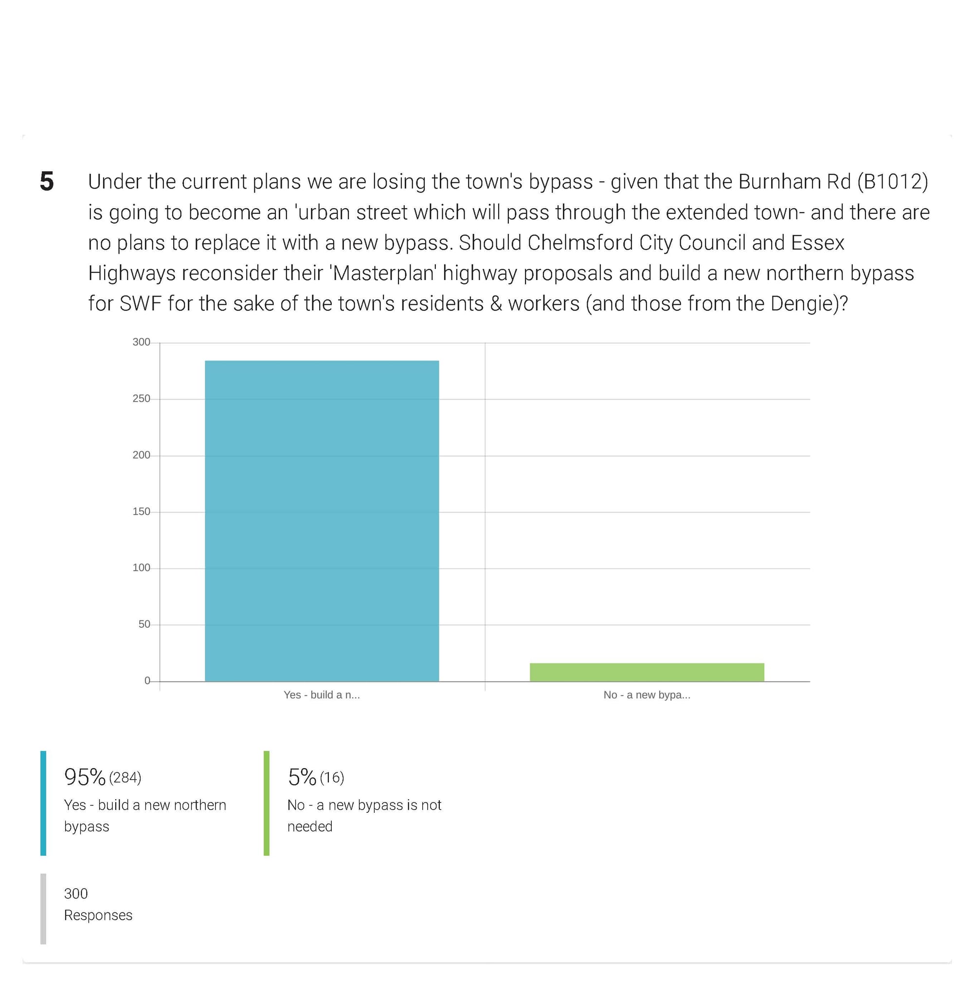
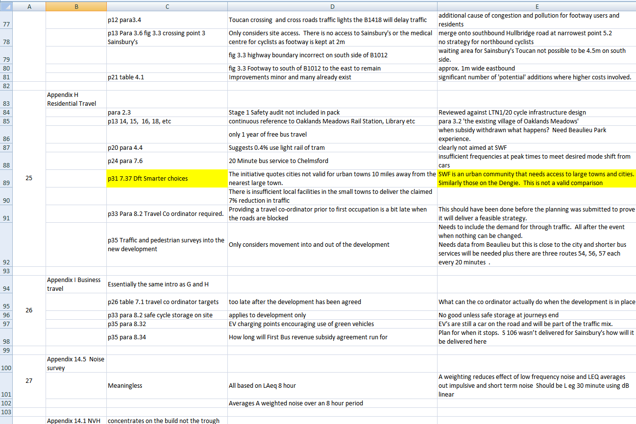
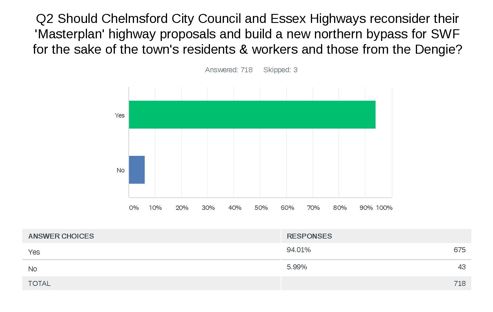
REMINDER OF SURVEY RESULT: 95% of respondents thought the current proposals will result in increased traffic congestion, 94% thought Chelmsford City Council and Essex Highways should reconsider their 'Masterplan' proposals and build a new northern bypass for SWF. The 3rd question was "On the basis of what you know about the Masterplan project so far, do you think it has been well handled - 87% said "NO" ... 8% said "YES" ... and 5% said "Don't know".
WHAT YOU CAN DO TO HELP
Writing to those who can influence and/or are involved in the decision making process briefly setting out your views is helpful.
This website contains the names and email addresses of the Chelmsford Policy Board members
https://www.chelmsford.gov.uk/your-council/councillors-committees-and-decision-making/committees-and-panels/main-committees/chelmsford-policy-board/
Here are some examples of members and contact details:
Councillor Graham Pooley: graham.pooley@chelmsford.gov.uk
Councillor Helen Ayres: helen.ayres@chelmsford.gov.uk
Cllr Nicolette Chambers: nicolette.chambers@chelmsford.gov.uk
Councillor Marie Goldman: marie.goldman@chelmsford.gov.uk
With thanks
ORIGINAL EXPLANATORY VIDEO PROGRAMME
VIDEO PROGRAMME
RECENT ARTICLES etc
Sleepwalking into Gridlock
MasterPlan for development north of the B1012 in South Woodham Ferrers
The B1012 struggles to cope during the rush hour at the moment, causing queuing on its access roads from the town. The additional traffic from the new development north of the B1012 plus increased commuter traffic from residential development in Maldon District to the Railway Station and beyond will exacerbate the situation. The six extra pedestrian crossings, between Shaw Farm and Saltcoats roundabouts, and another roundabout on the B1012 will also increase traffic delays substantially.
Most importantly, it appears the potential impact the proposed construction of Bradwell B Nuclear Power Station, Chinese involvement or not, will have on the B1012 main road has been ignored. Once work at Bradwell B commences traffic will increase considerably. Current assessments, included in the Bradwell B Company Consultation Document indicate average daily two way HGV movements of between 500 and 700.
Additionally, the construction workforce need to travel to and from the site. Bradwell B states there will be, ‘tens of thousands of jobs during construction’. Although they hope to provide temporary accommodation for up to 4500 workers adjacent to the site the remainder will have to travel by road. Even if they locate a suitable Park and Ride site all the remaining workforce would need to negotiate the B1012 whether by bus and/or private vehicle. The construction of Bradwell B is phased over a 12 year period. When you add Bradwell B to the mix of the new development of land North of SWF and other development in Maldon District it creates a perfect storm for the SWF section of the B1012.
It is apparent there is a lack of joined up thinking and foresight between the various local authorities/partnerships all of which will adversely impact upon the residents of South Woodham Ferrers and motorists travelling from Maldon and the Dengie.
The B1012 through SWF is the one section of highway that has to cater for ALL Bradwell B traffic movements, whichever strategic route is selected. The Local Authorities need to reconsider a northern by pass around the perimeter of the new development before building any new houses and link it to the A132. This solution would alleviate the problem for the residents of SWF and ease traffic flow for all motorists on the Dengie Peninsula who have to use the B1012. Traffic congestion in SWF creates pressure on some motorists to increase speed and take unnecessary risks after escaping the delays and this causes avoidable serious accidents and injuries on the A132 west of the town and the B1012 and B1010 to the east.
Whilst accepting the government’s need to build more houses the addition of 1000 plus houses brings a consequent increased demand and pressure on local services. It isn’t clear that the Masterplan recognises this or addresses it. The Govt’s infrastructure proposals also include road building which the Masterplan totally ignores.
Unless Chelmsford City Planners and Essex County Highways are willing to open their eyes and ears, then with or without Bradwell B, they are sleepwalking into gridlock and all local road users will suffer.
WIG (M.B.)
===========================================================================
THE FOLLOWING APPEARED IN FOCUS MAGAZINE
New town plan for the B1012 Burnham Road. Why not do It right first time?
Road chaos in SWF and the Dengie is the inevitable result of Essex Highways' plans for the town.
For chapter and verse, read on The intention of the masterplan is now clear. Keep the B1012 between the Saltcoats and Shaw Farm Roundabouts and slow traffic by adding another roundabout and up to 6 pedestrian crossings; providing ‘safe crossing points’ for our new residents and their children to access the station, schools and other town facilities.
Chelmsford City Council have confirmed the B1012 is an essential high-volume priority 1 (PR1) route from the Dengie and SWF. This plan seeks to significantly reduce its capacity. Is the intention to use Ferrers Road as a bypass? If so, we will have two main roads right through the middle of our expanded town.
On 23/24th January huge traffic queues formed in our town during the morning rush. The cause, roadworks at the new BP garage. The B1012 was reduced to one lane each way which slowed the traffic. These delays meant commuters from SWF and the Dengie diverted round Ferrers and Inchbonnie roads blocking off all exit routes for SWF residents. The result was gridlock. The new crossings will introduce stop start traffic, cause more noise and pollution, slow the traffic and have a similar effect.
In February (before the March lockdown) Traffic Survey Partners were conducting a 24/7 video traffic survey, in and around the Sainsbury’s Roundabout. Thismust have shown the extent ofthe morning rush queues on the B1012 and Hullbridge Road, between 6:30 and 8:30. Strangely these results have not been published.
Chelmsford City Council is now requiring the Developers undertake more traffic studies and modelling when detail planning applications are submitted for the land parcels shown in the masterplan. Surveys during the Covid Crisis will be meaningless. CCC must ‘do the right thing’ and provide a northern ring road before allowing building to start. Chelmsford City Council, Essex Highways and Planning have been relying on misleading and inaccurate data included in evidence books presented at the planning enquiry November2018. e.g. a Ringway Jacobs survey showed the B1012 was at 15% capacity (yellow) during the morning peak. However, there is heavy traffic (red) in Brent Avenue showing this was during the school run at 8:45 (see picture) not at the peak traffic time around SWF; 6:30 to 8:30. This coincides with the direct trains to London when commuters will be using the pedestrian crossings. A perfect storm.
The credibility of the documentation can also be brought in question when assertions are made that it is possible to increase the traffic flow at the Sainsburysroundabout and our peak congestion can be reduced by spreading the morning rush over a 3hour period.
These plans have been drawn up in the misguided belief that the surveys were accurate.
If you believe SWF deserves a northern ring road to avoid road major congestion in our town please make your comments before 24th July, quoting planning reference 20/00002/MAS
https://www.chelmsford.gov.uk/planning-and-building-control/view-or-comment-on-planningapplications/
WIG (AB)
===========================================================================
Further maps are available showing the situation in more detail
Bradwell Consultation document
Proposed One Way HGV route
500-700 2 way movements per day for 8 years
Return Route through SWF
Bypasses for Latchingdon, Mayland Steeple
Plans to use SWF ‘Ring Road’ - Road provisions stop east of SWF
Possible route for northern bypass
=======================================================================================
HOMEPAGE - BRADWELL B PROJECT SITE
https://bradwellb.co.uk/
and
https://bradwellb.co.uk/previous-consultation/
Stage One consultation summary document
https://bradwellb.co.uk/wp-content/uploads/2020/03/Summary-document.pdf
CONTAINS ROAD MAPS
===========================================================================
South Woodham Ferrers Town Council
Comment Date: Wed 22 Jul 2020
South Woodham Ferrers Town Council - Response to Stage 2 Masterplan Consultation for
Site 10 - Land North of South Woodham Ferrers
Relevant sections highlighted in yellow
Link: https://www.southwoodhamferrerstc.gov.uk/_UserFiles/Files/Masterplan%20Site%2010%20stage%202%20MC%20final%20comments.pdf
Executive Summary
The Town Council is disappointed to see the continual increase in the number of houses being proposed for site 10. The initial consultation was for around a 1000, the second consultation increased this value to over 1180 homes and the initial Masterplan Stage 1 consultation indicated a maximum stress test for the site of 1500 homes.
We now read within the Masterplan, that 1500 homes are proposed on the application sites for both Countryside Properties and Bellway Homes which is now at the maximum of all stress tests and supporting evidence.
The Town Council will challenge any further increase and will call in to question, a lot of the supporting evidence that has been used to deliver a sustainable growth development.
The following subject areas contained within the Site 10 Masterplan are covered in this response to the consultation.
Road Infrastructure
The Town Council finds the plan lacking in a cohesive road transport plan that takes into account all the factors that are likely to cause ingress and egress traffic congestion through the Local Plan time period until 2036. The Masterplan is far too centred and focused on traffic getting in and out of the individual building site sectors within the new development site 10 rather than presenting an integrated view that is sustainable to this increasingly congested area of Essex. Lack of consultation with neighbouring Councils to the South of Chelmsford regarding this Masterplan also demonstrates apathy in the modelling scenarios that were used as evidence for the Local Plan.
Power Line Infrastructure
Not enough due-diligence, representation or engagement here from the relevant organisations. The Town Council wish to avoid re-development or further disruption to residents whilst the national grid power infrastructure is addressed. There is confirmation from Bradwell that any generating capacity would need a new connection to the national grid. This concern also carries forward to the mounting perceived evidence that living under or above high capacity power lines is not popular among residents and the Masterplan has sports fields, a new primary school and a care home located very close to the current overhead power line route that bisects the Masterplan site.
Sports & Recreation Facilities
The Town Council is concerned that Chelmsford City Council has already not readily engaged with the Town Council have shown very little consultation evidence to the specific local needs of South Woodham Ferrers. We believe the new proposed sports recreational areas are being too heavily decided on Chelmsford-centric commercial service operations of the City Council and not based on local residential need.
Environmental Infrastructure
The Town Council believe there is a lot of conflicting evidence and references within the Masterplan where it contradicts the evidence presented to City Councillors who approved the Local Plan. We also believe that processes to acquire the necessary due-diligence and evidence were not followed where it was suspected that such evidence would harm the progression of the Local Plan. Lack of such process (when compared with other sites in the Local Plan) are likely to provide grounds for a judicial review.
Road Infrastructure
The Town Council's response to the consultation in regard to Road Infrastructure can be broken down into the following areas.
1) Site 10 Ingress & Egress and junction priority on the B1012 Burnham Road.
2) Average speed of through traffic creating new desired routeing
3) The number of surface-based crossing points to create an integrated community
4) The Ingress and Egress from the town through to county dispersal routes
5) The effect of new regional and national road infrastructure on the whole town's locality.
Site 10 Ingress & Egress junction Priority on to the B1012 Burnham Road and B1418 Bicknacre road
We note the following from the Masterplan.
The proposal to create three new junctions on the above-mentioned roads adding to the four roundabout junctions that are already present on this road.
The Town Council's concerns here are to do with the modelling and peak-hour priority flows of these junctions. Traffic models conducted in 2016 which formed part of the evidence base for the Local Plan are out-of-date to be used credibly as evidence of a sustainable throughput of peak traffic on the Burnham Road. The standard roundabout priority systems will give priority to traffic from the new development that will be detrimental to the current town's four access points through to the out-of-town road systems.
All modelling would require some form of peak time light control at the four current junctions to maintain the balance of access between through traffic, traffic from the existing town and traffic from new site 10. If there is no linkage here between the junctions, traffic flow at peak times will be a lot slower than that which could be achieved with the correct modelling and linking of control systems.
The Town Council does not support the view that the details should be decided and presented at the individual planning application stage. Planning applications will handle road junctions specifically individualised for each area a planning application is submitted within the application site and will not provide a cohesive and joined up model for traffic management within the town.
The Masterplan is the last stage of the process where a co-ordinated set of junction improvements can be presented. The Local Plan lacks the detail and indeed, the Local Plan consultation stated that the detail will come in the Master planning process. The Town Council does not believe the process adopted that readily shifts accurate modelling and co-ordinated designs further back to the planning application stage is a sound one for determining the needs of sustainable traffic priorities and flows for the proposed new junctions.
Average speed of through traffic creating new desired routeing
The Town Council notes the proposal to reduce the speed of the B1012 to 40 MPH and also notes there will be 6 junctions on this 1.5 mile stretch of road between the Hamberts Road Roundabout (known as the Maldon roundabout being the furthest East on the plans) and the Shaw Farm Roundabout (being the furthest West on the plans)
Whereas the Town Council in general supports the 40 MPH speed limit on this stretch of road, the new proposals will create an increased number of 'start and stops' required to transverse the road. This will reduce acceleration and hence speed even further, especially of goods vehicles and heavy load lorries. Add the gradient-factor of the road and the inability of goods vehicles to either gain momentum on the incline and/or drive on-the-breaks during the decline, we believe the average speed of this road will reduce to 20 MPH outside the peak times, and 5 ' 10 MPH during the peak. This in turns increases low gear, high engine revolutions in fully laden lorries and significantly increases resonating vibrations and noise pollution to the school and houses that border the road.
This analysis leads the Town Council to believe that a new preferred route issue will emerge, as it will be easier to cut through the existing town along the Ferrers Road between the two mentioned roundabouts. This route although longer, has the benefit of the through traffic receiving 66% of the priority routing through the town at each of the three roundabout junctions. Any well-meant junction improvements for turning left from the Ferrers Road onto the A132 to service the existing town will only improve the attractiveness of this new desired through-route.
The Town Council cannot support a site scheme which increases traffic through the current town causing a detrimental problem for our existing residents.
The number of surface-based crossing points to create an integrated community
We note the increased number of crossing points within the Masterplan located on the Burnham Road. The Town Council believes that with a 40 MPH limit, all crossing points will have to be controlled and this control, whilst needed for the safer crossing of the road, will add to congestion issues if the crossings and the controlled junction priorities are not deployed as an logical, co-ordinated system. If the average speed is slower, we believe more risk may be taken by people crossing the road 'ahead' of the control provided by lights.
The Town Council also believes that for the whole of Site 10, there is a significant issue with the desired route through to the William De Ferrers secondary school which will service the whole town. The Masterplan is very good at encouraging cycling and walking and the Town Council naturally supports these initiatives. We also believe that the desired route to the school for around 40% of the new site 10 will be via cycleways and paths that link through to Scholars Walk and the existing pedestrian and cycle underpass that crosses the railway line. The remaining 30% will cross at the Hullbridge Road junction, 5% at Shaw Farm and 25% at the new junction servicing the eastern side of the site 10 development.
The Town Council is concerned that the early years of secondary school are the years where risk taking versus common sense are most demonstratable and crossing the Burnham Road at surface level with its increased traffic flows; car drivers in stop-start-accelerate driving habits all contribute to a belief that utilising surface based crossing points for all of the crossings, especially on the desired route to the secondary school is not a safe, resilient or sustainable approach.
The Town Council does not support bridges at any location due to the close proximity of houses and the privacy issues that are generated by footbridges. However, for the crossing point 4 (The existing bridleway) and crossing point 5 new junction North of Hamberts Road, the Town Council would possibly support underpasses provided they are wide, can accommodate mobility assistance users in icy weather, are not too long to create a crime black spot, are well lit, are 24/7 CCTV camera monitored and can be clearly demonstrated that they will not flood in heavy or even medium-fall rain. The Town Council will not support unsafe underpasses and will actively campaign against the building of and/or closure of any underpass that does not demonstrate safety and confidence with cyclists and pedestrians.
With underpasses at these two points, a safe non surface route to the secondary school is created that would also be the desired route for 65% of the secondary school age population residing on site 10. The Town Council would also support any action to remove the bridleway status of the crossing south of the Burnham Road as there is no need to maintain this ancient status across the road.
Until we see evidence of safety concerns being presented, the Town Council cannot support the development of Site 10.
The Ingress and Egress from the town through to county dispersal routes
The Town Council is concerned about the increased level of traffic being generated the regional area and the lack of anything in the Masterplan that deals with the wider Ingress and Egress regional traffic flows.
The Town Council notes the preferred route submitted by Maldon District Council and Essex County Council in response to the Initial Bradwell Consultation. This clearly states that Essex County Council and Maldon District Council are in agreement that strategic route 1 (The blue route) is the preferred option for the route from Bradwell to South Woodham Ferrers and the start of Site 10.
This option improves all the flows within the Maldon Council Boundary but moves the pinch point to Hamberts Road Roundabout and the subsequent flow through the new expanded town. The Town Council can see no evidence that this new flow of traffic has been correctly modelled or integrated with the Site 10 Development traffic flows.
The process that determined the new traffic responsibility was 'Bradwell's to solve' even though the Local Plan was unapproved when the information became available has clearly not delivered the required evidence base for Site 10. The Town Council therefore believes and concludes that process followed which lead to the approval and adoption of the Local Plan is no longer sound.
The Town Council believes that the current road infrastructure from The Hamberts Road Roundabout through to the Rettendon Turnpike interchange is unable to cope with the modest increased traffic flows originally forecasted in 2016. Indeed the 2016 survey clearly demonstrated that the roads would be over capacity by 2036 even without the Bradwell increase and expansion of the Maldon district council area as a series of dormitory-based housing sites. As such, the Town Council cannot support any development of Site 10 without seeing a cohesive transport model carried out and agreed that addresses all concerns regarding proposed traffic flows and the handling of peak time traffic.
The Town Council believes that the fundamental modelling and forecasting that has been carried out is too Chelmsford City centric. Whereas the models for the City of Chelmsford and its contiguous parishes were very comprehensively created and fully support the evidence base for the Sites within Chelmsford City and the contiguous Parishes, this level of detail was clearly missing in any of the impact assessments and evidence base for the Site 10 at South Woodham Ferrers, especially as site 10 was the second largest site area and a strategic growth site. The email communication was that this would all be addressed at the Masterplan stage. As such, the process by which the Local Plan was presented for adoption, and the subsequent Masterplan failing to present the level of detail required for road infrastructure in the immediate areas surrounding Site 10, is clearly no longer sound.
The traffic flows of South Woodham Ferrers significantly differ from those of the Central Chelmsford conurbations. Being a dormitory town, with very little local employment and very little new employment offered by the Masterplan, our peak traffic hours are earlier in the morning and later in the afternoon than the central Chelmsford area and parishes. Our primary flows are to Chelmsford, Basildon, Southend and the A13/A12 routes to the M25. Very little joined up thinking has been carried out with the neighbouring boroughs to the south of Chelmsford when compared to the evidence based presented in conjunction with the neighbouring boroughs for the northern semis-sphere around Chelmsford. The Town Council was led to believe that the required detail would be available as supporting evidence at the Masterplan stage for site 10. We see no examples or evidence of this due-diligence on spatial traffic flows for South Woodham Ferrers and the surrounding southern semi-sphere boroughs contained within the Masterplan so we now find the process followed to produce and secure adoption of the Chelmsford Local Plan , and the Masterplan derived from it, is no longer sound. The Town Council cannot support the Site 10 Masterplan until the required level of due diligence has been completed and presented as part of the Masterplan process.
The effect of new regional and national road infrastructure on the whole town's locality
As much as the Chelmsford City Local Plan, and the Masterplan derived from it, concentrate on the immediate area surrounding Site 10, The Town Council believes the unique position of South Woodham Ferrers relative to the county's main trunk routes will create significant increased road dispersal problems for its residents.
The Town Council is fully aware that 'junction improvements' within the Town Parish may provide some minimal benefit to very local, school-run level traffic issues. The Town Council believes that such schemes will just push the peak time queues further along the road to the Rettendon Turnpike junction and beyond.
The dispersal at Rettendon Turnpike is primarily going to be the A130 as the other route out through Wickford and the Nevendon Road is already heavily congested with Wickford and Runwell traffic.
The Town Council does not believe any proposed improvements at Rettendon Turnpike will reduce peak traffic congestion, but moreover, just continue to push congestion further to the A130 pinch points, being the A12 / A130 junction and the A127/ A130 junction. The Town Council cannot support development of a site that will both increase and push the peak congestion for 80% of our car-based residents further along the road, especially as we can now clearly demonstrate that the A130 will see significant traffic flow increases based on the following.
a) The new Lower Thames Crossing will create a new desire route for A12 traffic from North Chelmsford and beyond through into Kent and Europe. Faced with the option of crossing northbound under the Thames, veering to the left for a few miles, joining the M25 for another few miles before exiting on the A12 and going eastbound to Boreham and beyond, the preferred route will be to turn left from the Lower Thames Crossing, follow the A13 round to the A130 and A12 (as this avoids the M25 and the low priority for right turn off the M25 onto the A12)
b) The new north Chelmsford link road will extend this desire route even further as when it is completed, it will create a new desire route from Braintree and beyond through to Kent again using the A130/A13 route and the Lower Thames Crossing. The current desire route from Braintree and north of Braintree is to turn right on the A120 to Stansted, travel down on the M11, then the M25, and then the M2/M20 Eastbound. The new desire route will be straight down the new link road and pick up the A130 / A13 to the Lower Thames Crossing.
Indeed, it can be demonstrated that you probably have to go as far North and West as Bury St Edmonds before the desire route to cross the Thames becomes neutral again (i.e. A11, M11, M25, Dartford Crossing). Even Traffic from Norwich which traditionally goes through Thetford on the A11 and follows the M11/M25 will be offered a better desire route to cross the Thames at the lower Thames Crossing using the A13/A130/A12 link.
These two new significant infrastructure projects (Lower Thames Crossing and North Chelmsford Link road) put tremendous additional strain on the A130/A12 junction (at Howe Green), the ability to ingress at egress at the Turnpike and the A127/A130 junction.
The A12/A130 (Howe Green) junction is totally inadequate to handle this capacity. Of the 15 Ingress and Egress paths available at this junction, 12 of these paths pass through the same single-direction, light-controlled system making it one of the worst designed junctions ever created for the joining of what are and will be two major trunk routes.
The A127/A130 junction is also a classic demonstration of poorly connected priority systems and even an extra exit route directly linking the A127 eastbound to the A130 Northbound will make this route become the preferred route for traffic that may still currently travel through Wickford to the Turnpike, so any benefit will just be taken up with increased traffic.
Road Infrastructure Conclusion
All of these changes coming and proposed, directly create a disproportionality higher peak congestion flow for the residents of South Woodham Ferrers Residents using the road system and as such, until the modelling is complete and proven and a satisfactory road infrastructure is proposed, the Town Council cannot support the Masterplan for Site 10.
The Town Council believes as the Masterplan does not contain the promised level of detail, and therefore that the process followed for obtaining the due-diligence and the evidence base presented to gain sign off of the Chelmsford City Local Plan is no longer sound. Any local re-painting of white lines or widening of junctions within the town are quite insignificant when the whole peak traffic flow to, through and from South Woodham Ferrers is considered.
Power Line Infrastructure
We note from the Bradwell Consultation that a new connection to the National Grid will be required. The Town Council concerns break down into two areas.
1) The timelines for any changes requiring significant work to the power cable infrastructure passing through Site 10 and the level of public engagement.
2) The effects of living near power lines and the understanding that science has moved on from that used when most of the existing National Grid overhead capacity infrastructure through site 10 was originally deployed.
Timeline for changes
The Town Council has concerns that the timelines for any changes to the power cables on Site 10 may come during the lifetime of the Local Plan and even when part of the new site may be starting to accept residents. The Town Council believes action can be take sooner and the pertinent decisions made to minimise any subsequent disruption to existing and new residents.
Bradwell have confirmed that a new connection to the national grid is necessary. The total GW generating capacity for Bradwell is 2.2GW. Based on that information, we believe one of the following scenarios is true.
a) A new overhead connection is provided following a similar route to the current one. In this scenario the whole layout of Site 10 would need changing and that would be unacceptable at Neighbourhood and Local Plan level.
b) If a new overhead connection is provided that routes around South Woodham Ferrers, then the Town Council would prefer the existing path through the town parish to also be re-routed away from the residential areas. This would not be an excessive cost if it was carried out at the same time as the new path.
c) A new overhead connection could actually follow a shorter route crossing under the Blackwater and joining the grid infrastructure further along towards Colchester. The National Grid should already know if this is feasible based on the dispersal of power and whether this new connection could handle the whole generating capacity. In this case, the power lines through Site 10 could be removed. We understand that the cables have been used for 'load-balancing' but such balancing could easily be achieved elsewhere.
d) The 2.2 GW electricity cable is a standard delivery size now and technology and building costs are much more understood. A grid connection could be run as an underseas cable straight down the coast to the Thames estuary and connected to the plethora of cables that existing in this area. In this scenario, the current capacity through Site 10 could also be removed.
e) A second overhead connection could be provided on a totally different route, and power distribution balanced between the existing connection and the new connection. In this scenario, any structural changes required to bring the cables through Site 10 into service would already be known and this work could be undertaken before any site development commences. In this scenario we would still ask that the money be made available from the Bradwell project to route the South Woodham Ferrers part of the cable route away from the town and Site 10.
f) The existing route is upgraded to handle the full capacity of Bradwell. If this is the case, this will be already be known, and both work can start on the Site 10 section and if the work is significant and involves new cables we would also ask for a re-routing of the route away from Site 10 as these costs are more readily absorbed if party of a larger infrastructure upgrade.
The Town Council cannot support Site 10 as a development site without clarity in this area (which from above, we have determined could be provided, even before the Power Station gets the decision to go ahead). We do not want a situation where secondary works occur at the site once the site starts development and/or residents have moved in.
The Effects of Living near power lines
The Town Council has concerns that the proposed area for a primary school, care home, and community centre are situated close to the power line route. In this information enabled world we have concerns that 'residential opinion' could cause revolt and may prevent these facilities being adopted by our new and existing residents.
We are fully aware as a Town Council there are arguments that both claim and counter claim the effect on health of living near or under high power wires are numerous and no official medically respected paper has provided a conclusive answer that there is a significant health risk. However, our concerns are not about the medical science but about a community's perception of it and where perception becomes reality, the problem exists to be solved irrespective of any medical conclusion.
It only needs one child leukaemia case to trigger a trend or one parent to say I am not sending my child to school there, or one allotment tenant to say I am not eating vegetables grown under that and the problem, by default, exists. There are articles that claim living within 600m of such lines can have an effect, but again nothing medically proven.
As such, the Town Council cannot support a development of Site 10 that sits under and near such power lines when they are in active service (and Nuclear power, in its role to provide base line power will be generating at capacity for 100% of the time in most cases). Especially and beyond, the Town Council cannot support the location of services for children and the elderly that are located in very close proximity to national grid overhead power lines.
Sports & Recreation Facilities
The Town Council has concerns that the areas of the Site 10 designated for sports and recreation do not have enough detail or longevity associated with them.
The main sports area shown on site 10 has no provision as to what sports will be serviced. Ask any sports club 'do they want better facilities?', they will always say yes.
The Town Council cannot support a Masterplan that does not demonstrate public need of sports facilities. The Chelmsford Playing Pitch and Outdoor Sports Strategy and Action Plan 2016 ' 2036 goes someway to identifying need for the Chelmsford district. However, South Woodham Ferrers and Site 10 is too far away from the central provision for the benefits offered within the document to be realised.
There was a lack of community engagement regarding the use of the sports fields and community spaces. We would encourage Countryside and Chelmsford City Council to work in partnership with the Town Council with regard to the individual sports and recreational use of the allocated sites. The Town Council believes it is closer to recognising the needs of the town's residents. On this note, the Town Council would be pleased to liaise with the City Council to determine the best use of the recreation allocations. The Town Council cannot support the development of site 10 without more detail being agreed and supplied as part of the Masterplan.
===========================================================================
Comments on New Development in SWF - from Planning & Building Control website
https://www.chelmsford.gov.uk/planning-and-building-control/view-or-comment-on-planning-applications/
Planning reference 20/00002/MAS
Published cut off date: Friday 24/7/2020.
Several pages contain only the following comment: "Handwritten comments received". Is this adequate or should a comprehensive record be available to the public?
We have removed the names from the following comments and replaced them by initials - the names are published on the official website (above)
Page 1
WL
Comment submitted date: Thu 23 Jul 2020
Our main concern is that a large number of additional families will be in the area which will increase the pressure on schools and medical arrangements.
The A132 is overloaded at certain times at present and the increase in traffic will damage the road and cause congestion.
We are also worried about the provision of a special area for Travelling Showmen. If this is not monitored then it will become another gypsy site situated close to the town.
Most of these concerns have been raised before so we hope that some actions will be taken before final approval.
LB
Comment submitted date: Thu 23 Jul 2020
Handwritten comments received
HL
Comment submitted date: Thu 23 Jul 2020
Dear Sir/Madam,
Re: 20/00002/MAS
I write in response to the Public Consultation document (June 2020) in reference to the proposed development of land north of South Woodham Ferrers.
Whilst I accept that due to the shortage of housing in this country it is inevitable land previously designated as countryside will be built on, this expansion should only happen once necessary improvements in local infrastructure have been fully planned and completed. Taking one look at the proposals put forward by Chelmsford City Council and the associated body of planners and developers, it is clear that no one involved lives or has any appreciation of the current conditions experienced by the existing residents of the town.
By way of example let me first address the subject of transport. On any normal weekday, any person who uses a vehicle to get to work must leave South Woodham Ferrers well before 7.00am to avoid what can easily be a half hour trek from the Shaw Farm roundabout to the Rettendon Interchange, the distance of a couple of miles. In the evening rush hour the same heavy traffic flow takes place in reverse with the tailback beginning on or sometimes prior to the Rettendon roundabout giving rise to very dangerous traffic conditions.
The sheer volume of traffic is a result of the constant building of housing between South Woodham Ferrers and Burnham on Crouch with absolutely no attention given to the improvement of or upgrading of the road system in the area.
Following the recent building of the Sainsbury's Supermarket and Crouch Valley Medical Centre, the installation of a roundabout at the junction of Ferrers Road and Hullbridge Road was necessary to allow vehicular access to the new buildings. This new roundabout with the additional installation of a new pedestrian crossing and bus stop has just caused further congestion, being the main route used by traffic coming from Southminster/Burnham on Crouch, and is exacerbated by the fact that the B1012 is quite narrow in both directions at that point.
You are proposing to build "around" a thousand new homes, plus a thousand square metres of flexible business floorspace and a site for Travelling Show People, in an area which is already overly congested and under resourced, thereby adding further problems to an existing dreadful situation. It is highly likely that this development will add probably at least another fifteen hundred vehicles, if no more, to the mix.
The A132 between the Shaw Farm roundabout and the Rettendon Interchange is a very heavily used road (as already mentioned) and I seriously doubt was built to the correct standard for the volume of traffic that utilises it. It is constantly suffering from surface movement and is currently having work carried out to level numerous areas of subsidence in both directions. I would point here that back in the 1970's when South Woodham Ferrers was originally developed, that very stretch of road was supposed to be a dual carriageway, but funds ran out. That dual carriageway should be built now as part of your "expansion plan" but we all know that won't happen. Shortage of funds still being the excuse no doubt.
Unfortunately the railway will be of no assistance as the current franchise holder is already on record as stating they will not be increasing the frequency of the current service or the number of carriages per train. The fact that the service, as it stands, is not particularly good and far from reliable, particularly at peak times, will only encourage even more of the new residents to take to their cars, and it follows thereby, increase road congestion plus increase pollution.
Allow me to now address other topics of infrastructure. If you accept that many of what were the existing GP surgeries were no longer complying with current regulations, then the building of a new health hub was a welcome replacement. However, the powers that be ie: NHS England, Chelmsford City Council et al, appear to have never consulted the affected and interested parties being the GP's and the patients, as to the positioning of the new facility. It would seem that Sainsbury's wanted to have a supermarket in South Woodham Ferrers and to get it they had to "oblige" Chelmsford Council by having a health hub on the site.
Bearing in mind the Health Clinic in the town has now been closed as "no longer needed" and two GP surgeries were on the same site, it would have made more sense, taking into account the central location, to redevelop the site as the new health hub, rather than build it on the edge of town with more inconvenient access especially for senior citizens without their own cars and people with limited mobility.
Additionally the GP surgery known as "The New Surgery" situated at the end of Tyler's Ride closed a couple of years ago, thus dispersing its' patient list with all the remaining town GP's who were already oversubscribed. If the town's GPs are already over capacity regarding their list of patients, where are the new residents going to go for medical care? "Around" a thousand new homes roughly means approximately three thousand five hundred residents, maybe more. Perhaps you should be making allowances for a new GP surgery in amongst your new homes and industrial business area.
This brings me on to provision for schooling. Within the "Masterplan" you have designated an area for a new primary school, recognising that the influx of new residents will require the need for additional primary school capacity, which South Woodham Ferrers no long has, due to the fact that Chetwood Primary School in Shirebourn Vale, was closed down some years ago as surplus to requirements. The real problem will now lie in where do these additional primary school children go for secondary education?
The William de Ferrers School is the obvious choice, but I believe that they are already operating close to full capacity. Never mind, the students in question can always be bused to other secondary schools, thereby putting more vehicles on the already overstretched roads and of course increasing pollution to boot.
However, I believe there is an answer to the housing problem and one which will allow you as a local authority to for-fill the demands made by central government, without destroying the character of South Woodham Ferrers as a very pleasant rural town.
Following the current COVID-19 pandemic and the necessary restrictions that have been applied, it has become obvious that for many, working from home will be the way of the future. Employers will therefore question the need for expensive office space in cities/retail parks and, as a result, cut backs will be made in the office space required, leading to a massive glut of empty buildings.
This unused office space will likely stand empty for years to come and indeed will present an incredible opportunity to end the housing shortage. All you have to do is convert all that unwanted office space to apartments and the housing shortage will be solved at a stroke. As more people will be living in the city centres, the demise of the high street will be halted as the convenience of shopping locally where you live will be immediately embraced. There will be less need to drive to work and pollution will be reduced. Council spending will be reduced and towns like South Woodham Ferrers will no longer have to be blighted by unwanted and unnecessary development.
I am not against change or modernisation per say, but you don't build an addition storey on a house without reinforcing the foundations first. You do not have to look far in our area of Essex to see the vast expansion of housing that has taken place in the last fifteen years alone. Chelmsford, Maldon, Braintree, Colchester, and numerous sites in between, have seen vast increases in residential construction and increases in population. Many will argue therefore that South Woodham Ferrers cannot be spared taking its share of further expansion, but it would be totally irresponsible to undertake this "Masterplan" without first addressing the infrastructure improvements that have been ignored for so long and which are desperately needed.
Finally I must take issue with the photograph of the proposed area to be utilised on the front of your document: Public consultation on a masterplan for the land north of South Woodham Ferrers dated June 2020. As you are aware, the photograph is an aerial view of the land which is subject to the building work proposed. But it is far from being up to date.
The BP petrol station and M & S outlet just off the Shaw Farm roundabout, which has been open for at least two years, are missing, as is the new Crouch Valley Heath Hub and adjoining Sainsbury's supermarket, which opened last year and had been under construction a year prior to that. That photograph is so old it could have been taken twenty years ago and is therefore highly misleading. If this represents the attention to detail applied to the "Masterplan" being presented to the people of South Woodham Ferrers, then heaven help us all.
JB
Comment submitted date: Thu 23 Jul 2020
I object to this plan on the following points:
1. The medical centre will struggle to cope with the influx of the residents of 1,000 new houses. See comments of in the Focus magazine of July 24, 2020. "It is not beyond the realms of possibility that there will eventually be a 50 per cent increase in the number of patients registered at the Medical Centre."
2. Drainage Strategy. The northofswf.co.uk pamphlet states that water flow on the site will be managed... "so that water is discharged from the site at rates no greater than the existing greenfield run-off rate". This ignores the fact that the existing greenfield run off already causes regular extensive floods on Creephedge Lane and Burnham Road.
3.The map showing proposed new minor roads from the proposed housing areas appears to indicate that traffic would have to travel up towards the proposed major road. This would cause traffic jams around the proposed schools during drop off and pick up times and would force extra traffic down the B1418 and onto the B1012, causing greater congestion on already overloaded routes.
4. Travelling Showpeople site: The proposed five serviced plots could soon be overrun and there is no apparent proposal for the site to be managed to stop this happening.
RR
Comment submitted date: Thu 23 Jul 2020
During the period of this development the current Northern South Woodham Ferrers (SWF) bypass B1012 will also be used by the traffic for the Bradwell power station build. Despite what official studies say the B1012 road is all ready overloaded during many periods of the day and the addition of further roundabouts and crossing will further delay traffic. Planning a further bypass is essential and this should be prepared before the main development starts.
One only has to look at the A132 from Shaw Farm on South carriageway to Rettendon which has broken up to a dangerous level, and has a temporary 50mph speed limit for safety reasons. This road will be used by development traffic and Bradwell development traffic.
The key roads of A132 and the B1012 are simply not fit for purpose with current traffic flows let alone the build traffic for Northern SWF and Bradwell power station developments.
The nature of this development as currently perceived is isolated from the main town. Across the overloaded B1012 people will have to cross to access certain facilities. And of course everyone in SWF has to cross the B1012 now for the much reduced medical facilities in the town. These facilities of course will be stretched further with the northern development
I notice on some of the documents that , may be involved in the development of new homes. This company has a bad record of exploitation of customers by manipulation of leasehold rules to link ground rents to high levels of inflationary increases or selling on the land to property speculators who then introduce large inflationary ground rent increases. Other developers are no better one only needs to see and others many statements in parliament on this subject.
Both of my children (not now living in SWF) have had bad experiences with I would not wish anyone purchasing in the Northern development to be exploited in this way.
Ultimately there will, I expect, be some development North of SWF. Can the authorities insist that all sales are either Commonhold or Freehold . The laws regarding leasehold are under review but the landowners are cunning and manipulative and will not follow fair practice unless they are forced to do so.
Many residents in SWF will remember the travellers issue in Basildon.
Whatever the rights or wrongs and prejudices it would appear that social problems exist when such sites are co-located within urban communities. Some form of management of this sight is essential if it is not to become the problem like that of - which was very expensive for the local ratepayers to sort out.
What will happen to the railway service especially at peak hours? It is a single line for both up and down and is generally full to bursting at peak hours. Parking for the train station in the roads around the station usually results in significant problems. I have seen accidents and witnessed the buses stuck in King Edward Road for over an hour due to the number of cars that park in the road. ( I have photographic evidence of these claims). Speeding in King Edwards road is on the increase. It has been since the removal of the speed bumps. The restrictions that are bound to occur on the B1012 will result in more traffic trying to circumvent the problems by taking to Hamberts Road/King Edwards Road in an attempt to avoid traffic.
King Edwards road is basically a residential street and already large Articulated Lorries come down the road and shake the houses. This will increase as vehicles with "Sat Nav assistance" try to navigate around the problem. This is on a route which appears from the plan to be a cycle route !
JB
Comment submitted date: Thu 23 Jul 2020
I regularly walk up Hullbridge Road to where it meets the B1012 and use the controlled pedestrian crossing to the retail development. Turning right into the B1012 from Hullbridge Road towards the crossing can be a terrifying experience especially if a large truck is coming round the roundabout at the same time and even worse any traffic at all turning into Hullbridge Road. I am inclined to leap into the hedge to get out of their way as the space on the road is very tight indeed. It is also unnerving waiting to cross the B1012 at the crossing as traffic seems to come so fast both along the road and off the roundabout. It would seem to be madness to do anything that increases this traffic with a housing development and adding the enormous development of the new Nuclear Power Station at Bradwell into the mix makes it all the more concerning.
JH
Comment submitted date: Thu 23 Jul 2020
Whilst I appreciate the need to build more housing there is not the infrastructure to support a development of this size in the area. Trains will not be able to accommodate the extra passengers that result from these homes. The roads out of SWF are already extremely busy from 7am, if not earlier, and the extra traffic will make this worse. There are often long queues from the Shaw farm roundabout back past the Ford dealers and the traffic from the new development, will make getting out of town from this direction almost impossible. The doctors at the new medical centre are barely enough to cope with the existing population, but the extra number of patients will mean that getting an appointment will be even more difficult. In addition the information regarding the site for travelling show people has been sketchy. More information on who these people are, what the site will be used for and for how long should be provided. Is it intended for storing equipment or residential, and who will be responsible for ensuring its proper use?
AC
Comment submitted date: Wed 22 Jul 2020
1. B1012 Burnham Road
In the Masterplanning Process it was proposed to make the A132 a dual carrige way form the Rettendon Turnpike to Marsh Farm Roundabout.
This means we are feeding the dual carriage way traffic straight into a 40mph Zone.
Where is the Bypass for South Woodham Ferrers.
The B1012 is also featured as a trunkroad for the construction traffic of the new Bradwell Powerstation.
How will this work as the B1012 is now almost at a standstill during rushhour.
2. Will the B132 get a major overhaul rather than piecemeal repairs to cope with the increased traffic.
I drove over a repaired part of the road today and there was still a considerable dip in the road surface.
3. What does affordable housing mean? Will South Woddham residents have first refusal to give local families a chance to stay in town.
Also will the new builds have the latest insulation and environmental fixcutres to ensure energy sustainability?
4. It says in the Local Plan Policy, that healthcare provisons have been made through the new health centre. This is doubtable as it is very difficult to get GP appointments as ist is. Will ther be more GP appointed to the health centre to cope with increased demand?
5.How often will the site for Travelling Showpeople be used?
6.Can the sewage works cope with the increased demand?
7. Will the Neighbour Hood Centre have facilities for
years 11+?
9. Will there be affordable Town Shuttle Buses to and from the railway station to avoid further issues in the residental areas around the station?
10. We were told by the train operator, that longer trains can not be supplied on the branchline. How crowded will the trains be after the passanger increase as most of the people who purchase the new houses will be commuters.
What about the safety aspect of a single line track, which will be used for nuclear material to supply the new Bradwell Powerstation?
11. I thought Bluebell Hill was a place of Outstanding Beauty and building restrictions apply.
PV
Comment submitted date: Wed 22 Jul 2020
Handwritten comments received - 18 individual comments.
Comment submitted date: Thu 02 Jul 2020
Handwritten comments received - 12 individual comments.
SA
Comment submitted date: Wed 22 Jul 2020
Response does not transfer over.
Comment submitted date: Mon 20 Jul 2020
PUBLIC CONSULTATION - MASTERPLAN SUBMISSION FOR STRATEGIC GROWTH SITE 10 Ref: 20/00002/MAS, NORTH OF SOUTH WOODHAM FERRERS
I am writing on behalf of the Chelmsford and Central Essex RSPB Local Group that has some 350 members of the RSPB, most of whom live in the CM and adjacent postcode areas. The Royal Society for the Protection of Birds (registered charity no. 207076) exists to give nature a voice, protecting birds and other wildlife and their habitats.
CHELMSFORD LOCAL PLAN
STRATEGIC GROWTH SITE POLICY 10 - NORTH OF SOUTH WOODHAM FERRERS
Land to the north of Burnham Road (B1012) and east and west of the B1418, as shown on the Policies Map, is allocated for a high quality comprehensively-planned sustainable extension to the existing town, that maximises opportunities for sustainable travel, in a landscaped setting. Development proposals will accord with a masterplan approved by the Council to provide:
Amount and type of development:
- Around 1,000 new homes of mixed size and type to include affordable housing
- Travelling Showpeople site for 5 serviced plots
- 1,000sqm of business floorspace
- 1,900sqm of convenience retail floorspace.
Within a section titled "Historic and Natural Environment" it includes the following bullet points:-
- An appropriate landscaped setting for development consisting of sufficiently dense planting belts and natural buffers to development edges and local Wildlife Sites, to provide a network of green infrastructure to mitigate the visual, biodiversity and heritage impacts of the development
- Mitigate potential effects due to recreational pressure on nearby designated European sites
- Provide areas for natural SuDS and flood risk management
Within a section titled "Design and Layout" it includes the following bullet points:-
- Development to be planned around a coherent framework of routes, blocks and spaces that deliver areas of distinct character
- Development shall predominantly be defined by and seek to retain the existing pattern of historic and landscape features
- Layout to be defined by a coherent network of wide green spaces to include formal and informal sport, recreation and community space that is well connected to Public Rights of Way
- Where they must remain, the layout should make positive use of utility easements, such as electricity powerlines and gas mains.
The Chelmsford Local Plan paragraph 7.329 states "The land to the north of the Town is predominantly open, save for field boundaries, and offers views across an undulating landscape form. The development extents should be limited to areas within the site with lower topography and/or where excessive visibility can be mitigated. Given the open context, the character of the development must exhibit a sufficiently open and green character, with greenways and open spaces and appropriate buffer and strategic landscaping to the outer margins, to respect the historic landscape character. The development must seek to preserve key wildlife connections and offer sufficient density and connectivity of green infrastructure to provide protection for wildlife and where necessary compensate for the impact on wildlife that occurs from development. This will include offering adequate protection of the Local Wildlife Site at Bushy Hill and other sensitive areas within and outside the site. The site will provide a high-quality development ina landscape setting.
Paragraph 7.330 states "Flood risk management and natural, on-site SuDs are necessary to ensure there is no increased flood risk on site or to adjacent areas and to ensure a sustainable form of development. Such features should not limit or adversely overlap with the main function of public open spaces.
Paragraph 7.340 states "The development must provide a high quality, connected layout and building design that reflects a strong sense of place, high quality streetscape and comfortable living environment, which works in sympathy with the local landscape. Key views and utility easements including overhead powerlines and a high-pressure gas main (if remaining) will be likely to influence the location of green spaces and routes, and create the layout framework for buildings.
EXTRACTS FROM STRATEGIC GROWTH SITE POLICY 10 MASTERPLAN SUBMISSION - MARCH 2020 prepred jointly by Broadway Malyan and David Lock Associates on behalf of Countryside Properties, Bellway and Essex County Council.
The section in the master plan titled NATURAL ENVIRONMENT gives the following description: - "The Bushy Hill Local Wildlife Site lies adjacent to the site on Bushy Hill, including Edwinshall Wood, an area of potentially ancient broadleafed woodland, and is protected by a Tree Preservation Order. The Local Wildlife Site extends southwards into part of the site to the north of Burnham Road, comprising an area of acid grassland, with a series of terraced slumps, important for scarce invertebrates.
The majority of the site is in arable agricultural use. The area around Mill Hill comprises an area of semi improved grassland. Within the remainder of the site there is a well-developed network of hedgerows, with a field pattern that is still recognisable in part from the 1881 Ordnance Survey map. Some lengths of hedgerow have been lost over time, occasionally marked by trees. Most hedgerows are predominantly comprised of Hawthorn and Blackthorn.
Two watercourses run through the site towards Fenn Creek, to the south-west. There is one pond on site, and one adjacent to the boundary. There are numerous ponds in the surrounding area, especially to the north and east of the site.
There are some good quality broadleaf trees within the site particularly along the central watercourse and the watercourse north of Shaw's Farm in the west of the site. A belt of relatively recent mixed planting is evident on the south edge of the site, associated with the construction of the Burnham Road. Other trees are associated with field boundaries.
The hedgerows, watercourses, and field margins provide ecological connectivity through the site and into the wider landscape.
Ecological Surveys have been undertaken on site during 2017 and 2018 to identify the important habitat features. These features are identified on the plan opposite. Species found to be using the site include Reptiles, Bats, Breeding and wintering birds, Badger, and Great Crested Newt."
The section in the master plan titled ECOLOGY gives the following description:- "Ecological Surveys undertaken on site in 2017 and 2018 identified the Bushy Hill Local Wildlife Site, grasslands, ponds, watercourse, and hedgerow and tree habitats as important for foraging and roosting bats, Great Crested Newt, reptiles, foraging and breeding birds and Badger.
The intrinsic value that habitats including mature trees, ditches, hedgerows and ponds have with regards to biodiversity has been key in the design of the master plan with a focus on a living landscape that benefits all. As such, habitats of importance will be retained, protected and enhanced within the scheme to provide improved habitat for protected species in the long term.
The existing stream, mature trees and hedgerows are being retained and a grassland buffer will be established along the ditches and hedgerows to improve the quality of the habitat the hedgerows provide for invertebrates, reptiles, amphibians and foraging bats.
Although some existing grassland will be lost as a result of the development, additional acidic grassland and wildflower rich meadows areas will be created around Bushy Hill Local Wildlife Site to enhance the wildlife habitat. This site will be further enhanced with the creation of new ponds, providing additional breeding habitat for Great Crested Newts, reptiles, and breeding and wintering birds and the replanting of gappy hedgerows to provide multi-functional wildlife corridors for mammals, amphibians and reptiles.
The drainage strategy has been designed to complement existing ecological features to provide a Blue / Green corridor through the site and to ensure habitat connectivity between these features for protected species and providing a multifunctional open space for residents and wildlife, thus reducing recreational pressure on local designated sites. In addition an increase in ponds will provide a net gain in breeding habitat locally available to Great Crested Newts.
The site will be designed to provide a biodiversity net gain. A lasting management regime will be established to ensure that the habitats are maintained in optimum condition for protected species. The grassland areas will be managed as wildflower meadows, with scrub patches, providing habitats that are in decline within the existing agricultural landscape."
The section in the master plan titled GREEN GRID gives the following description:- "The 'Green Grid' constitutes the spatial framework for the proposed masterplan, providing a comprehensive landscape led structure within which the proposed uses can be distributed.
The 'Green Grid' is generated by combining the strategies for drainage, ecology and landscape, also taking into account the constraints imposed by various utilities that run through the site, in particular the overhead power lines. The edges of the corridors created by the utilities will be softened to avoid overly straight linear open spaces.
The 'Green Grid' can be understood as comprising a number of interlinked elements.
Higher Ground
The higher ground including Bushy Hill and the rising land and prominent hilltops to the north, much of which lies beyond the site boundary, establishing the northern edge to the masterplan and providing a landscaped setting of strong character to the masterplan as a whole.
Stream Corridor
The corridor alongside the central tree lined watercourse, creating a strong green spine through the main part of the site, wirth ecological enhancements and integrating many of the SUDS features.
North / South Corridors
These three corridors cross the main part of the site roughly perpendicular to the central stream corridor. The alignment of each corridor is generated by a combination of existing site features and potential opportunities.
The central corridor runs between the BurnhamRoad / Hullbridge Road junction and the central hilltop north of the site. This alignment retains and reinforces the existing visual connection across the site from Hullbridge Road and Burnham Road, and also provides an extension through the site of the existing movement corridor along Hullbridge Road, linking the heart of the new development with the railway station and the heart of the town.
The western corridor runs from the Burnham Road / Willow Grove / Ferrers Road junction towards the western hilltop. This provides the opportunity to create a visual link through the site focused on the hilltop, incorporating pedestrian and cycle access. It also enables the retention of the existing overhead power lines, by following their alignment.
The eastern corridor is aligned on the existing Footpath 24 and retained hedgerow alongside, creating a further visual and movement corridor through the site aligned to important existing site features.
East / West Corridor
This corridor runs intermittently from east to west across the whole site, providing further connectivity across the site parallel to Burnham Road. It also enables the retention of the existing overhead power lines, by following their alignment. This corridor will be meadow and grassland with occassional tree planting where utility constraints allow.
Eastern and Western Edges
These areas define the eastern and western edges of the masterplan. Their landscape character will respond to their location on the edges of the masterplan and the creation of appropriate relationships with the wider landscape.
CHELMSFORD AND CENTRAL ESSEX RSPB LOCAL GROUP COMMENTS
We welcome the proposals set out in the Masterplan proposals regarding Natural Environment & Ecology. The proposals show how the existing Local Wildlife Site Ch150 Bushy Hill is to be retained, enhanced and restored. This LoWS comprises of a mosaic of acid grassland, scrub and old broad-leaf woodland that has deteriorated through ploughing and lack of management so its restoration is good.
There is a net gain to ecology, which is welcome and the 'green grid' strategy sets out clearly how this can be achieved with ecological corridors providing connectivity across the site. This is complemented by the use of existing drainage ditches and the provision of new ponds.
We believe that any new development should incorporate the vision of "Homes both for people and wildlife" and suggest some additional items be included within the proposals:-
- A dry culvert be installed beneath B1012 Woodham Road, together with appropriate fencing, in the south eastern corner of the site to encourage mammals to travel beneath the road rather than over it to access land to the south - shown on Figure 1.
- The creation of ponds adjacent to the existing brook in the north east of the application area shown on Figure 1. This will create additional habitat next to grass areas designated for sporting use.
- Install an owl box into a suitable existing tree.
- Lighting should be designed to avoid unnecessary disturbance to wildlife.
- Renewable energy and water recycling incorporated within the new houses.
- Permeable driveways to help reduce water runoff.
- Interpretation panels to help residents to understand their environment and wildlife.
- Bird boxes, bat roosts designed into new buildings.
o Specific bat and swift bricks are available from Ibstock Brick Ltd and can be used in the construction process. The swift bricks should be placed on northerly facing walls. As many houses will not have north facing walls it is recommended that at least 2 swift bricks per property are installed. Bat bricks should be placed on walls overlooking hedgerows and trees. Details are illustrated in the Ibstock Technical Note shown in Appendix 1.
o Readymade nest cups suitable for house martins are also available. These should be ideally placed in small groups. Do not place above doors or windows and a shelf fitted beneath can minimise mess. Details are illustrated in Appendix 2.
- Wildlife permeable boundaries to gardens to allow corridors for reptiles, hedgehogs and other mammals. More information is available at https://www.hedgehogstreet.org/hedgehog-friendly-fencing/ Pictures are illustrated in Appendix 3.
- A legal agreement to secure those areas of land designated as grassland etc., but outside of the permission area together with funding for future long-term maintenance within the development and adjacent areas.
Figure 1 and Appendix 1, 2 and 3 have been sent by email to Chelmsford City Council on 20 July 2020.
Page 2
JF
Comment submitted date: Tue 21 Jul 2020
I moved into SWF 42 years ago, at that time it was advertised as A Small Riverside Town. I been happy to see the area grow to the size it is today, but this major development is a step to far! We regularly see a family of Buzzards flying over the proposed area, and nesting site would be destroyed. Our children and now grandchildren have all enjoyed exploring the area. The Town of South Woodham Ferrers would become unrecognisable. I noticed on the plan there is an area for Travelling Show People, I thought the circus was an attraction in great decline due to the cruelty to animals, [text removed]This all may seem trivial, but on this occasion I feel I need to make my objection to the proposed development.
JC
Comment submitted date: Mon 20 Jul 2020
Dear Sir / Madam,
Re Planning -20/00002/MAS - Proposed Development of Land North of South Woodham Ferrers - Masterplan Public Consultation - Objection to Size of Scheme and Emerging - "Travelling Show Peoples Site"
I have recently taken a look at the proposed expansion plans for South Woodham Ferrers and I have to say that I am very concerned about the extent of expansion to the countryside town, and very concerned and worried about the "Emerging" requirement for a "Travelling Show people" site.
Extent of expansion:
I have lived in South Woodham Ferrers for 35 years and seen it develop into a beautiful, tidy, correctly sized countryside town which really doesn't need further expansion and in particular a Travelling Show People's Site. Essex / Chelmsford Planning should be proud of the development of SWF and follow / replicate the model elsewhere rather than expand and ruin SWF through expansion. There are other places along the river estuary and beautiful Essex Countryside where a similar small town could be expanded to the size of SWF, eg Althorne or Fambridge. Looking at the overall scheme, the footprint of it and number of houses, it is excessive by far for adding to SWF - adding over a third to the existing area. A smaller expansion might be tolerable but not one this size and impact to the feel of and operation of the town.
Travelling Show Peoples Site:
However, if expansion in SWF must go ahead, I am really opposed to the siting of a Travelling Show people site. In my time in SWF I do not ever recall a need for a Travellers' Show People site, there has never been a show ground close to SWF other than the occasional show in Maldon, Wickford, Chelmsford or Billericay. I know that there is the BrownStock Festival just outside of SWF once a year for a couple of days and a circus for a week at the Marsh Farm but I would not class these events as permanent / temporary available showgrounds and besides on the days these events (circuses / concerts) take place, the Travelling Show People live in their mobile accommodation on or adjacent to the actual show site. This being convenient for them and of course sensible as it allows for good security and safety measures to be put in place to protect both them and the general public from crime, property theft and vandalism.
The neighbouring towns where shows do take place are generally some many miles from SWF making it inconvenient for the the Travelling Showpeople to pack their belongings securely to enable them to commute safely many times during their stay, putting more heavy traffic on the local roads.
It is not clear if the "emerging" proposal is to have static homes on the SWF site or just providing space, standing and utilities for caravans and motorhomes? If there really is to be a site how would this site be managed and how long would Travellers be allowed to stay? How would the site be maintained to ensure that it doesn't become . To me and as a council Tax payer I would think that the travellers should have to pay a fee to stay at such a site, if it must go ahead, and the charge should be commensurate with council tax rates.
As the name implies a "travelling show people" site is for temporary stays and as such should and must have a maximum short term stay period imposed (eg a couple of weeks) with a no return period of say 3 months. This should and must be strictly monitored by an official warden and good procedures for eviction put in place.
So in summary I would seriously challenge if the approach to have a Travellers Showpeoples site in SWF is correct for both the the Travellers Show people and the residents of SWF. I am also concerned as many other residents in SWF that the "emerging" requirement for a "Travelling Show people" site is just an upmarket term for or re-badging of, a "Travellers" or a "Gypsy" site. As local residents have already indicated and written articles in the local Focus magazine suggesting that this could lead to the residents of SWF living alongside a permanent / semi-permanent gypsy site similar to the infamous Crays Hill encampment? Would a spot near Rettendon Turnpike or Rawreth, or possibly outskirts of Battlesbridge, be a good option for such a site, much more suitable for transport options and separation from permanent housing.
In summary please lodge my objections and consider them seriously and in full during your future assessment of the plans.
Regards
AB
Comment submitted date: Mon 20 Jul 2020
17 July 2020 Objection to the masterplan 14 July 2020
Summary
At each stage of the consultation process assurances were given that detail traffic surveys and capacity analysis would be completed to support the masterplan. These commitments have not been honoured and Chelmsford City Council are proposing to 'leave it to the developers' and the community will suffer.
The masterplan claims its objectives are to 'maximises opportunities for sustainable travel'
and then declares it the design will feature will use the existing B1012 and add up to 6 multi-user crossings to allow movement from the new development to the existing town centre, railway station, schools and swimming pool.
It is obvious that these two objectives are not compatible
The plan has been conceived to meet the needs of the developer(s) ignoring the effect that the proposed crossings on the B1012 will have on the residents South Woodham Ferrers and commuters from the expanding towns and villages in Dengie. Whilst the good words in 5 plan documents may meet the requirements of the new residents 'on the site' the effect of the development on the existing road infrastructure and residents hardly considered. Core planning directives are being ignored (see end of document). For some reason Chelmsford City Council is unwilling to meet its own core planning objectives when agreeing new developments. To push this development is a gross dereliction of duty as it will be introduced in the full knowledge that using the existing B1012 is not suitable and the proposals will increase congestion and pollution on this and Ferrers Road. The quality of life of existing and future residents of South Woodham Ferrers will suffer considerably.
Key issues
Since the start of the public consultation Chelmsford City Council (CCC) and Planning have always maintained that high level traffic surveys will be undertaken to support the development of a robust Masterplan. Traffic data provided in the evidence books to support the SoS enquiry have been shown to be incorrect and used contradictory junction modelling results, incorrect peak times and ignored their own traffic flow measurements. This resulted in an incorrect conclusion that the B1012 is well below capacity. None of these have been updated. E.g. EB 025 fig 3.16 shows the B1012 is at 15% capacity. The data for this plot was taken at 08:45 during the school run. This is confirmed by the slow traffic on Brent Avenue. Any plans based on this and similar information will be wrong.
Specific objections
Section 5 Creating the framework masterplan
The proposed actions will slow and cause serious delay to traffic wanting to use the existing B1012. The nett result will be that drivers will divert round Ferrers Road making this the main artery to and from the Dengie. This is totally unacceptable for resident of South Woodham Ferrers and must not be allowed to happen.
The contradictory data in Evidence books and experience after the introduction of the Sainsbury's development does not support the statement that 'the site can be satisfactorily connected on foot and by cycle to the main facilities within South Woodham Ferrers, including the local schools, the railway station, the shopping and employment areas'.
Further
subject to appropriate traffic modelling at the planning application stage to demonstrate that the impact on journey times would be acceptable. Current journey times out of and through SWF require commuters to start 30 to 60 minutes earlier to avoid the traffic jams in and around the town during the morning rush.
Traffic modelling MUST be completed before the masterplan is agreed and detail planning applications are allowed to be submitted. The individual housing parcels shown in the master plan are defined by the position of the B1012 and no matter what the results of the modelling or surveys show there will be no opportunity to re align the B1012. As this is a Priority 1 route it is the responsibility of Chelmsford City Council to provide a road network that will not detract from the quality of life for current residents in the area as set out in core policies CP19, DM29, DM30B, EPE2, ECP5, MG1, MG4, QL2, QL3,
There are real traffic data available. A traffic survey mid to late February 2020 was commissioned from 'Traffic Survey Partners'. This was before lockdown (23 March) so the results will be valid. For some reason the information collected has not been made available or published. Perhaps this is because it would show that the B1012 is heavily congested.
Traffic data have been presented to CCC that show the effect of actions that slow the traffic on the B1012. On 23/24th January the town was gridlock by central reservation works requiring two way running on the B1012. All feeder roads in the town were gridlocked and the traffic from the dEngies was backed 1.5 to 2 km coming into the town effectively shutting off the Dengie. This information has been ignored.
The master plan focuses on movement within the development. Comments on the B1012 to the south of the development are given significantly less consideration.
It is inferred that the addition of the Sainsburys crossings and roundabout have been a success. The reality is these have caused additional congestion at peak times and pedestrians find the layout unsafe due to HGV's overlapping the kerbs and footways. The traffic modelling to support 14/000830/FUL asserted that traffic flow would be improved which is not the case. Data is available that support the reality.
Crossing 1 (Junction 19 over capacity in evidence book EB026)
Existing Burnham Road / Ferrers Road Willow Grove Roundabout
This crossing has significant issues with safety. There is insufficient clear forward visibility for traffic approaching from Wickford on the A132 for a crossing. Given the high flow rate during the PM peak and the proximity of the proposed crossing to the roundabout it will mean that with a queue of 2 cars stopped at the crossing any additional traffic will block back onto the circulatory carriageway creating a significant hazard. The design will compromise the slip road onto the BP site. Supporting documentation for this application suggests that the traffic capacity at this junction should be reduced. This is a nonsense as this is the key junction taking all the traffic wanting to use the A132. The design intention needs to be made clear in the master plan and cannot be delegated to developers.
Crossing 2 (junction 20 over capacity in evidence book EB026)
An additional lane was added eastbound as part of 14/000830/FUL. This is unmarked. The LH lane should be for B1418 only. There is a high risk of collision when 2 vehicles are heading east. At peak times the model asserts a 165 second delay (traffic queue) which blocks back over crossing 3 by over 130 seconds yet there is only a 28 second delay modelled at crossing 3. 100 seconds of queueing traffic has just vanished...... Clearly the junction modelling has serious errors and the evidence cannot be used in the design.
Crossing 3 (Junction 21 in evidence book EB026)
The statement is incorrect, misleading and must be corrected. Despite what it says in the supporting documentation and evidence books there is no opportunity to increase the traffic capacity at this junction being bounded to the north by the medical centre and telephone exchange and to the south by grade 2 listed Tabrums and housing on Brent Avenue. There is no scope to increase the footway width to the footway in front of the grade 2 listed building 'Tabrums'.
The footway from the crossing into Hullbridge Road is at maximum feasible width which is significantly smaller than that needed for a cycle path. Hullbridge road footway narrows significantly south of Brent Avenue.
Any results from the modelling of the signalised crossing at this roundabout (for 14/00830/FUL) will be inaccurate as the model shows no pedestrians using it, Any results to indicate the effect on traffic flow will be invalid and cannot be carried over to this study.
Despite statements that the peak hour is from 07:30, the actual AM peak for the roads are from 06:30 to 08:30. Data from evidence book EB026 p141 confirms this. This exactly matches the direct trains to London ensuring that the crossings will be heavily during the peak hours. No modelling results exist that shows the effect of the crossing on traffic congestion. Essex Highways advised that the crossings would be used every minute, each causing a minimum of 33% reduction in the flow capacity of the road. There will be no way to schedule all the crossings to minimise delays.
Crossing 4 (Junction ?? In evidence books)
The intent is to delete the bridal way which is unacceptable. A longer crossing time will be required for horses. The effect on traffic will be as above but with the addition of secondary school children using the crossing between 08:00 and 08:30
Crossing 5 (not discussed In evidence books)
The purpose of a left in left out junction here needs justification. There is no side road at this point which is 100m north of crossing 6. The plan is for this to be an unofficial crossing point which will not meet the objective of providing safe crossing points for pedestrians and cyclists between the development and the town. It should be deleted or an underpass provided.
Crossing 6 (not discussed in the evidence books)
No details of the proposed crossing are given. This must be detailed. The masterplan must be updated to demonstrate that any crossing will be feasible and safe.
Section 2
Strategic context.
The submission conveniently avoids the fact that the B1012 is the main route and designated as a PR1 from the Dengie. It fails to consider the expanding population and commuters living in and to the east of the town, Burnham, Southminster etc . On May 27 2020 In a written answer on May 27 2020 Chelmsford City Council (CCC)confirmed the Burnham road is a. 'Priority One Route (PR1) in ECCs functional route hierarchy......they provide the main arteries for the movement of people, goods and through traffic.... PR1 routes feed traffic to and from the inter-urban routes......... carry large volumes of traffic during the peak hours when people are trying to access/leave town centres.' Section 2 of the masterplan fails to consider this fact. The only proposed mitigation is to provide 'junction improvements'.
Urban analysis
It incorrectly asserts that the railway line 'is the most notable cause of severance in the town'. There are 3 traffic crossing and cycle/pedestrian tunnel that allows proven free movement to and from the town centre. If this is considered such an issue to warrant a comment then the same standard must be applied with the proposal to have a 1.5km major trunk route with 6 pedestrian crossings through the middle of the expanded town. This dual standard demonstrates that the masterplan design is unsafe and seriously flawed.
Section 3
Site Analysis
Fails to emphasise the B1012 is a key PR1 high volume traffic route to and from towns in the Dengie
Section 4
Creating the Green Grid
Providing a northern ring road within the development boundary will have no more impact on the eco system of the area than the proposed housing. This will then allow the existing B1012 to be reconfigured as a green and pleasant 20 mph rural road removing the need for crossing and pedestrian/cycle tunnels or bridges. Low cost pedestrian/cycle tunnels could be provided under a new road similar to that providing access to Woodham Fenn under Ferrers Road to the West of the town
For information important Chelmsford City Council Core planning policies
CP19 providing a secure safe, high quality development with 'excellent' connections to existing urban area.
DM29 safeguard the living environment of the occupiers ..... 'The development shall also not result in excessive noise, activity or vehicle movements'; and ... 'the development avoids unacceptable levels of polluting emissions by reason of noise, light, smell, fumes, vibrations or other issues',
DM30B the development will not have an unacceptable impact on air quality and the health and wellbeing of people.
EPE2 will not have a negative effect on local environment, slowing peak hour traffic, stop start traffic at crossing points on the B1012 effectively making Ferrers Road the main road through South Woodham Ferrers
ECP5 will support essential commercial transport movement ............on road and rail networks.
MG1 to ensuring new and existing neighbourhoods are easy to get to and well integrated with strategic route networks.
MG4 promote the advantages of urban living, gridlock on the B1012 at peak hours will dissuade people from living and commuting in SWF and the Dengie.
QL2 improve links between new development surrounding neighbourhoods
QL3 improve road safety by making pedestrian routes across high volume and congested streets to get to service, residential and shopping areas.
JH
Comment submitted date: Sun 19 Jul 2020
What additions to infrastructure are included in plans? What additional facilities are being provided for the increase in population - e.g. education, medical, dental services? Have the providers of utilities submitted acceptable plans for their own developments? Can these be viewed, and if so, where? As a pensioner, I am fully aware that many of my contemporaries have difficulty accessing medical resources since the recent centralisation? How are their needs being catered for? Already parking facilities at Crouch Vale are hopelessly inadequate for non-Corona virus activity levels. - how is that issue being addressed in these plans?
Comment submitted date: Sun 19 Jul 2020
As a resident of the town for 30 years, I have experienced first hand the increase in the inadequacy of local town centre parking facilities. It can already be very difficult to secure a parking space around the Asda premises in the town centre, and this problem can only increase with added population. What provisions are being made to ensure that parking does not become even more difficult?
Comment submitted date: Sun 19 Jul 2020
Traffic on the road north of the current town is often difficult to navigate during rush hours (obviously not currently during the Coronavirus emergency) if you are trying to leave the town and join the exodus. What are projected traffic volumes after the development? How is the free flow of traffic to be engineered and maintained? What projections have been used in determining this development location, and what is their basis? What consideration has been given to the additional impact of the Bradwell project traffic. It goes without saying, in light of existing traffic, that consideration of SWF as a park and ride site for Bradwell workers must be out of the question, but confirmation would be appreciated.
M H
Comment submitted date: Sun 19 Jul 2020
I have lived in SWF for almost 50 yrs. I wonder how many of the people objecting to the proposed development and complaining that it will ruin the town can say that? There are a lot of hypocrites in SWF. You don't want anymore houses built but you didn't mind moving to a riverside village that was decimated by excessive building. Whilst I think the road network is already overloaded I do get rather annoyed with the NIMBY attitude. People have to live somewhere and who knows maybe some new houses will improve SWF?
PJ
Comment submitted date: Fri 17 Jul 2020
This proposal does not expand SWF, but rather creates a separate enclave to the north, cut-off by the main B1012 road. A more logical proposal is to take a new road round the back of the new development. This would filter all current and future traffic travelling from/to the Dengie away from the town.
The provision of a left in/left out junction (referred to as the 'third access') seems particularly badly thought out, as there appears to be no way for any traffic from the residential areas served by this junction to head West unless they go down to the roundabout and all the way round to pick up the B1012. This would also be required in order for them to access the 'local centre' or in fact any of the facilities in the new development by car, which, despite the councils wishes, will still be most peoples preferred method of transport. Reducing the speed limit to 40mph will only work if it is enforced, something that, like most roads, is only done sporadically.
CF
Comment submitted date: Fri 17 Jul 2020
Hello
I am concerned about the housing development taking place for a number of reasons:
Surface water run off - with the area being built up with tarmac and concrete etc there is likely to be some flooding on the Burnham Road. There was excess water on the road shortly after the Sainsbury's site went up. This will be problematic and cause delay to commuter journeys and potentially accidents.
Burnham Road - most of the new housing occupants will live in Woodham as a commuter town as there won't be many jobs for them here. There will be a lot of traffic on the Burnham Road which is the only way out of South Woodham Ferrers and will cause even more delay to current residents who commute out of Woodham. Also there would be more pollution and not good for the environment. There are farm fields and animals that would be affected by the pollution.
Railway - there is only a single railway track at South Woodham Ferrers therefore the trains do not run very often and the train carriages are already full once passengers alight at Wickford as it is. As SWF is mainly a commuter town, the new residents are likely to also commute and the trains would become very busy and uncomfortable. The regularity of the train timetable is something that cannot be improved due to the single track.
Youth - there isn't much in Woodham for the young people to get involved in. Instead they resort to hanging around areas and using laughing gas canisters. With more families potentially living in Woodham the children would be bored which isn't good for wellness.
In summary, I don't think the site is viable as there isn't the infrastructure available to accommodate it. The rail network is a separate entity so how will this be affected?
OF
Comment submitted date: Fri 17 Jul 2020
I have no objections to the development plans for Land North of South Woodham Ferrers. However here are my concerns which as a resident with a young family i ask that these are taken into consideration and actions set out before the masterplan is adopted.
1. Highway safety concerns - Burnham road is the main access road in and out of SWF. Can plans be made to incorporate another access way. The use of Burnham Road will be congested.
2. Lack of sufficient Public Transport - improvement to the Bus and train link to other towns. The Train station will have to be expanded to accommodate the increasing population from this development.
3. Lack of early years infrastructure - provision of more nursery, pre school facilities, playground etc
4. Consider provision for another secondary school
5. I object to the Travelling Showpeople Site - we have sufficient surrounding towns with showpeople site, we do not need one in SWF especially with main access route as Burnham road. How will such site be prevented from becoming a permanent home for travellers.
SH
Comment submitted date: Fri 17 Jul 2020
Handwritten comments received
HF
Comment submitted date: Fri 17 Jul 2020
Handwritten comments received
Page 3
Handwritten comments received
Page 4
Handwritten comments received +
DF
Comment submitted date: Fri 17 Jul 2020
It seems obvious to me me that a major problem with this development is the B1012 Burnham Road. Once completed, this road will bisect the town, making getting from one side to the other very difficult, if not, dangerous. The addition of 1000 new homes will add considerably to to amount of traffic using this road. The B1012 is the major artery from the Dengie peninsula, where there are also many housing developments taking place, adding to the already heavy traffic.
Was any consideration given to a new road north of the development? Obviously, this would relieve the traffic on the Burnham Road.
I can foresee a major problems with the amount of traffic with the current plan.
Page 5
PH
Comment submitted date: Thu 16 Jul 2020
I object to this development as currently proposed for several reasons.
1) The building of 1,000 new homes will have a an extremely detrimental impact upon the already congested roads that currently serve South Woodham Ferrers. This will only be further negatively impacted by the reduction in the speed limit on the Burnham Road from 60mph to 40mph and the creation of six safe crossing points on Burnham Road.
2) The application states that healthcare provision has already been provided by the new health centre. This health centre is already unable to meet the needs of the existing residents let alone the residents from a further 1000 homes.
3) The application advises convenience retail floorspace has already been provided through the Sainsbury's supermarket. Without alternative access to the supermarket from the new housing area there will be a severe negative impact upon the traffic trying to access the supermarket with severe congestion leading to poorer air quality.
4) The application states that there will be a viable and regular commuter bus service tying in with train timetable and bus services to Chelmsford, Wickford and Basildon. This has not been achieved with the existing bus services so is highly unlikely to be achievable with 1000 new homes to also serve.
5) The application states that there will be a Travelling Showpeople site for 5 serviced plots. The legal definition of Travelling Showpeople is "Members of a group organised for the purposes of holding fairs, circuses or shows (whether or not travelling together as such). This includes such persons who on the grounds of their own or their family's or dependants' more localised pattern of trading, educational or health needs or old age have ceased to travel temporarily, but excludes Gypsies and Travellers as defined
above."
It is hard to imagine any fairs, circuses or shows being held in the near vicinity of these plots and therefore it would seem that this is to be used to provide serviced plots for Gypsies and Travellers. If this is the case then the application should clearly state this.
6) The application is very vague on the drainage strategy merely stating that measures are proposed to manage and control water flow from the site to Fen Brook. This provides no detail of how this is to be achieved and what the environmental impact will be.
PS
Comment submitted date: Wed 15 Jul 2020
I strongly object to these development plans. I am proud to live in a rural environment and think you have already ruined this town by adding the ugly Sainsbury's site and m and s site. The infrastructure can not cope with these plans, you are tuning where we live
+ Handwritten comments received
Page 6
Handwritten comments received
Page 7
Handwritten comments received
Page 8
Handwritten comments received
Page 9
Handwritten comments received
Page 10
LW
Comment submitted date: Mon 13 Jul 2020
This is horrendous there is no need for a huge development of this area the road struck can't cope as it is the local structures of health are at breaking point yes you bid the buildings but health care workers have no wish to work here this is open countryside and that's the way we like it leave the open green space alone we don't all want to live in city's most housing developments are struggling to find buyers as it is look at beaulie park and Maldon An absolute no !
NM
Comment submitted date: Mon 13 Jul 2020
Handwritten comments received
AH
Comment submitted date: Wed 08 Jul 2020
We have received details of The Masterplan for the above development and respond as follows.
We have two main issues with the proposed development with the first being the health risk from the electricity cables that cross the site and consider that this risk alone is good reason to abandon the development. Much has been written regarding the health issues, particularly with regard to children in the close proximity of overhead electricity cable, two of which are included below;
https://electricalnotes.wordpress.com/2012/02/17/effects-of-high-voltage-transmission-lines-on-humans-and-plants/
https://www.cancer.gov/about-cancer/causes-prevention/risk/radiation/electromagnetic-fields-fact-sheet
We note that the building of schools is included in the plan and we therefore think it highly irresponsible that such a development could be considered in these circumstances and should therefore be immediately abandoned. In any case the Council should categorically, publicly and clearly state that, in their opinion, there is absolutely no health risk.
Our second main objection involves the Burnham Road which is one of only two main roads serving the Dengie Peninsular. Consequently new residential developments in Maldon, Burnham and Southminster have added to the amount of traffic carried on this road which is plainly incapable of operating efficiently. However, despite common sense screaming that this road be kept as free as possible from interruption in order to at least try to keep a flow to the passage of traffic not only has a small roundabout recently been constructed but other similar such obstacles are now proposed. It is beyond the realms of our comprehension as to how this considered without upgrading this road to the required standard that would at least have a chance of accommodating the growing and potential traffic. The plan is bereft of any reference to road improvements save for a mention that improvements to key junctions to be considered in the future, i.e. official speak for pigs may fly.
Large articulated lorries use the Burnham Road and these vehicles have much difficulty in negotiating the Hullbridge/Burnham Road roundabout as I have found a few times to my consternation when they have been well within social distancing of my car. It is not the fault of the lorry drivers but the 'brains' behind these ill thought out schemes. To compound this mess we understand that the construction traffic for the new Bradwell power station will not be allow to use the route through Danbury so will have to use the poor old Burnham Road. The only good thing is there is no mention of making Burnham Road narrower as proposed in the eccentric Local Plan.
I understand that an engine is at its most efficient at around 56 mph which corresponds with that allowable on an urban road. Therefore with regard to air pollution it is best that traffic clears the area as quickly as possible but instead we will have a situation of several interruptions on the routs that will result in stop/start traffic in long queues causing pollution - it is important to note that Woodville Primary School borders this road.
While not as serious as our two main points there are other aspects of the plan which are highly dubious;
- Why was Chetwood School closed only for a new school to be built in the development?
- Drainage measures will be 'managed' but we are not sure how this works on sloping ground, I know I spill my tea down my shirt if the cup is not level. The subsoil is heavy clay which is not conducive to the use of soakaways for surface water and therefore will have to be piped putting more strain on our creaking drainage system. We do not agree that the discharge rate will be no greater than at present. At present rainwater is taken dealt with by evaporation, being taken up by the extensive vegetation and percolation into the subsoils. The proposal results in the removal of established vegetation and much of the area covered by hard landscaping resulting in surface water having to be piped away.
- 1000 square metres of business floor space will be so very useful while there is plenty of empty such premises already in the Town, the same goes for the flexible workspace facilities.
PS
Comment submitted date: Tue 07 Jul 2020
I have the following comments, as a resident of South Woodham Ferrers, in regards to your policy SGS10 having been given a copy of the master plan brochure for the land north of South Woodham Ferrers. Whilst I appreciate the need for more housing in the UK there must be some appreciation of the long term effect of large developments being "bolted on" to existing towns. so in no particular order:
1 Road access
The developers stand to make a fortune on the highly inflated UK house market, yet the only commitment to improving the road access to the Dengie peninsula is a very vague "Detailed improvements to existing junctions (such as the Rettendon Turnpike) to be considered in future detailed planning applications for the site". 1000 houses plus schools and businesses will put approximately 1000 extra cars on the A132, (Burnham Road) every day, no matter what the pretence about public transport links and cycle paths is. The proposed nuclear power station also will add huge volumes of traffic and the developers for that are equally vague when it comes to that stretch of road. It is physically disintegrating and currently has a temporary speed limit in place because of its condition. The developers of the projects, not the local tax payers, must fund a dual carriageway upgrade to the road between the Rettendon Turnpike and South Woodham Ferrers.
2 Affordable housing
No housing in the area of South Woodham Ferrers is affordable. Most properties are in excess of ten times the average UK earnings, let alone the UK minimum wage. There need to be specifics about how much housing is affordable and how the Council will ensure it is actually affordable. 999 £350,000 houses and 1 £250,000 house will do nothing to help the majority of youngsters and lower earners who are living at home or renting nearby, it will simply turn the area into an overpriced London commuter town for people who can't afford Surrey but don't currently live in this area.
3 Allotments
Three areas are earmarked for allotments. Has any research been done to see if there is any demand for this? Also why could this not be used for additional space for housing, or to keep the same number of houses but give them more space? That way the huge influx of very keen vegetable growers anticipated could use their own gardens. If there must be allotments, at least put a covenant on the land that it may not change use other than back to agricultural land, to prevent the developers simply saying it wasn't a success in a few years time and throwing another 100 houses up with less scrutiny.
4 Travelling Showmen
The most politically correct part of the entire brochure. 5 serviced plots. How will it be enforced that the users are "Travelling show-people" and not simply "Travellers"? Who will pay for these serviced plots and how will the Council ensure there is no financial burden on the current tax payer if they cannot collect the money? How will numbers be enforced, what does 5 plots actually mean, how many people or vans per plot? The plan will encourage other "Travelling showpeople" to arrive, where will they go? I imagine the little used allotment land directly opposite would be likely. Who will pay for clearing up the mess? Let me be frank, Essex has not had very much success with this sort of thing. The Dale Farm fiasco and £6.6 million pound eviction cost to the tax payer (BBC 19/10/2016) should be looked at in the cold light of day.
JW
Comment submitted date: Mon 06 Jul 2020
Land North of South Woodham Ferrers Masterplan consultation 20/00002/MAS
Response from Essex Bridleways Association
We wish to make the following comments on the proposed Masterplan for Growth Site 7 within the newly adopted Chelmsford Local Plan.
We are particularly disappointed that despite the requirements in the Site Policy for this allocation which requires the development to consider 'new and enhanced cycle routes, footpaths, Public Rights of Way and bridleways...' that the opportunity to enhance the off-road network for all vulnerable road users has not been taken.
You will note that the site lies between two existing bridleways - 237_21 in the east which ends at Willow Grove, and 298_25 which begins within the site allocation itself and runs north-eastwards. Bridleway 237_21 runs westwards, linking the site with the extensive network at Rettendon Common and East Hanningfield; 298_25 links both the northern network at Purleigh and eastwards (along the old railway line) to Cold Norton. A bridleway link here would complete a significant part of the jigsaw and offer an excellent joined up safe route which can be enjoyed by all vulnerable users - walkers, cyclists, equestrians and the disabled and we urge you to include such a route along the northern perimeter of the site allocation.
The masterplan description does show potential recreational routes on the land north of the red-line allocation, and we suggest that this area would be the ideal location for a bridleway link.
It is undoubtedly necessary for a good masterplan for any new development to consider links with the wider environs of the site, and of course it must conform with the relevant Site Allocation policy in the Local Plan. In our opinion it is lacking in any such vision of connectivity outside of the site boundary, and certainly does not take the opportunity, as laid down in the Policy, to provide 'new and enhanced' routes. Bearing in mind that bridleways can contribute to sustainable transport as they are accessible to all non-motorised modes of transport, provision of such routes will also enhance the sustainable travel option for residents, both those who will live in the new housing, and for the wider community. This is of course supported both in the Policy itself and the Reasoned Justification.
There is significant horse ownership in the villages to both the east, north and west and the existing bridleways are very well used; our members are keen to see a bridleway link which we believe would be well-used by local riders. We can, if required, produce information confirming the level of horse ownership within the area that any new bridleway would serve.
We trust that these comments will be taken into consideration when the final iteration of the masterplan is produced.
RR
Comment submitted date: Sat 04 Jul 2020
I have the following observations:
1) Bradwell Nuclear Power Station.
(i) Are you aware the Bradwell Consultation Document indicates their site 3 will be a temporary staging post for lorries and park and ride (for contractors for the power station). This seems to be the same or next too the proposed western edge of the new town development.
(ii) There may be overlap of the building of a new part of South Woodham Ferrers with a large number of haulage lorries making deliveries to the potential new Bradwell site. The traffic problems will become horrendous.
2) Rainwater.
The current proposals indicate fresh water is something to be got rid off by draining to Fen Creek, a tidal creek. I suspect this could cause flooding around the creek.
In view of the facts that:
(i) Chelmsford Council has declared a global heating emergency.
(ii) Essex is the driest county in England.
(iii) Long range forecasts based on estimated global heating indicate a regular occurrence of temperatures of 40C or above. I know from experience such temperatures can be unbearable.
(iv) There is apparently little shade, from trees perhaps, in the new development
(v) Water demand has grown recently and will continue to do so.
I propose an alternative, treating rainwater as a very valuable resource and not something to throw away, thus:
(a) Sewerage and rainwater should not share the same pipes.
(b) Each new home should be fitted with a large water tank, say 1000 litres minimum, such that they can be filled with filtered water from roofs. Such stored water to be available to householders for their own use.
(c)Collection of rainwater in tanks prevents flash flooding. There is much guidance on the internet on this subject. Indeed many Mediterranean countries and islands, such as Hawaii, collect rainwater.
(d)Surface water and tank overflows could be collected in a new, purpose built lake (as exampled by RHS Hyde Hall). Any surplus could be pumped to the local fishing lake or RHS Hyde Hall (if they agree)
(e) If such a lake was built, by planting trees around the lake to provide shade, and erecting picnic table and benches, a valuable new amenity for inhabitants would be made.
3) New homes with gardens.
I suggest a dwarf apple tree be planted in every garden; such apples being of different varieties of eating apples. This will encourage people to enjoy their own grown food, create shade, lock up carbon and encourage bees and wildlife. There is guidance on the internet to support this idea.
4) Sewerage works.
Does the current works have sufficient capacity to deal with more sewerage such that raw sewerage will never be discharged into the river Crouch.
5) Will the recycling centre be enlarged?
6) Will the train service be improved?
Finally I hope Chelmsford Council will act on residents concerns rather than ignoring them as in the past.
MC
Comment submitted date: Fri 03 Jul 2020
Handwritten comments received
JC
Comment submitted date: Fri 03 Jul 2020
Handwritten comments received
BS
Comment submitted date: Fri 03 Jul 2020
Letter received
J&IG
Comment submitted date: Fri 03 Jul 2020
Letter received
Page 11
Handwritten comments received
Page 12
Handwritten comments received
Page 13
Handwritten comments received
Page 14
Handwritten comments received
Page 15
Handwritten comments received
Page 16
VM
Comment submitted date: Fri 03 Jul 2020
Handwritten comments received
DM
Comment submitted date: Fri 03 Jul 2020
Handwritten comments received
NA
Comment submitted date: Thu 02 Jul 2020
There is now an opportunity through the planning process to ensure that all new builds fully support the reduction of greenhouse gas emissions to slow the advance of climate change. Keeping to current requirements will not do that, but Chelmsford City Council could lead the way in only permitting housing with near zero carbon footprints. So please only permit applications that have inbuilt solar panels on all roofs and no gas boilers or other fossil based fuels. The new homes must have no central heating and be adequately insulated with installed heat pumps.
NC
Comment submitted date: Wed 01 Jul 2020
This proposal will be a disaster for South Woodham Ferrers.
The current road network will not be adequate to carry the level of traffic proposed with this development.
The proposal to slow down traffic using the B1012 Burnham Road will hamper traffic and increase congestion.
The fundamental issue to address the traffic issues is that there needs to be a bypass around South Woodham Ferrers. It is understood that Chelmsford City Council has a budget of £10million and that a bypass would cost approximately £4million to build. The development is being brought forward on the cheap.
The provision of high density housing on this site is simply to generate more profit from the development. The roads proposed through the site are too thin / narrow in order to maximise the development area.
A new power station at Bradwell is proposed to be built and could generate up to 700 HGVs a day on local roads. When combined with the proposed SWF development this could lead to 5-10 years of traffic jams.
It is also noted that travelling showpersons site is located immediately next to the early years provision site. Parents who may use the early years facility may find this arrangement strange so there must be adequate segregation of the two uses.
MHW
Comment submitted date: Wed 01 Jul 2020
It is hardly my place to comment on the work that has been done to bring forward this project, although it is a pity that it should be necessary.
As I see it, there are two weaknesses. The first is that all the new building will do is to add to what is primarily a dormitory town with very limited light industry. As such, it will add to the need for workers to commute, adding to congestion and this at a time when purported ecological policy is to try and reduce carbon emissions and use of fossil fuels.
This leads to my second point, which is that the real availability of employment will come from Bradwell B power station, who suggest that they will need some 900 permanent staff, once it is up and running (many more in the interim). It suggests that this level of development should move east, to, say, Southminster, which would make housing available for the local work force.
In commenting on Bradwell B, I am also pointing out that surplus heat from the operation should be used to introduce district heating (to developments hopefully nearby) in preference to dissipating the heat in the atmosphere, and out to sea.
JB
Comment submitted date: Tue 30 Jun 2020
Currently the early morning rush hour past the top of SWF from East to West on the B1012 involves queuing; the addition of these additional junctions/roundabouts from the new site will cause even longer queues as they will have priority. The railway Co. say there will not be any additional trains and no additional parking; so where do all the extra cars park ; will they clog up nearby streets ?
The new Health Centre has only recently opened and they fear they do not have facilities to support the extra patients. Then take into consideration the proposed renewal of the Bradwell nuclear site and the extra heavy lorries that will bring doesn't bear thinking of. Will the new roundabouts be built better than the newest one by Sainsburys? That is a complete danger because of the size of the roundabout road and the sinage.. lots of potential for accidents
This, and with any more developments east of SWF then the town needs a northern buy-pass to alieviate the expected extra traffic
RL
Comment submitted date: Mon 29 Jun 2020
I have read only the consultative document sent through the post as I assumed this would contain the key information.
Under the heading "movement strategy" in that document, I see that the intention is to prioritise pedestrian and cyclist safety. There is no mention of another important objective; that is- providing and maintaining vehicular traffic flow on the Burnham Road whilst enabling free egress on the roads feeding the Burnham Road. I.e. no or minimal congestion.
In my view the proposal for roads and cycleways will do the opposite. There has been congestion on exit roads at rush-hour for some time and this has been exacerbated by the new small roundabout and controlled crossing at the medical centre/Sainsbury's. I believe it will be made worse by the addition of another such roundabout, crossing and left in/left out junction with cycle and pedestrian crossing. I assume that to meet the objective both new crossings will be controlled. There is likely to be well over a thousand additional vehicles as a result of the new housing on the site and with the traffic from the east as a result of both housing developments there and the construction/use of the new Bradwell power station there could well be significant traffic jams; wasting time,fuel,damaging the environment, and no doubt frustrating and stressing all involved.
All this traffic may well lead to "rat runs" and perhaps the most affected by this would be Ferrers Road and Inchbonnie Road. What are the proposals to prevent cars and lorries going through housing areas?
It is obviously good to have more pedestrian foot paths and more cycle paths but they should be separate in order to achieve pedestrian and cyclist safety as the stated priority. Foot paths used by cyclists, (as many are currently), is inconsistent with this objective. Moreover, some existing cycle routes are on roads where cycling is anything other but safe. There is no safe way out of SWF on a bike; what is to be done about that?
It is regrettable that the proposal is not for a ring road north of the town as I believe that all 3 objectives/priorities would have been more reliably met in that way, both in the short and long-term.
DR
Comment submitted date: Sat 27 Jun 2020
Dear Sirs,
Having reviewed the plan I felt I was in a 1980's time warp the way the development had been crudely put together.
Firstly South Woodham Ferrers is already in a state of decay with insufficient community facilities, pathways and parks that have not been maintained and in many cases pathways are so unkept they are no longer safe or passable. The town centre was not built for today's online society and should be developed as with other brown sites across South Woodham Ferrers, before hatching another master plan with minimal facilities and maximum financial benefit for the developers.
There is insufficient consideration to the environmental impact on the landscape and the surrounding infrastructure which already is unable to cope. If you want to cycle out of South Woodham Ferrers towards Wickford you now take your life in your hands in the last 10 years as the traffic has increased significantly, especially with further developments in Southminster, Burnham etc. The train infrastructure is only a single track and today cannot cope with the number of people using already today. The Woodham Road exit out of South Woodham Ferrers is just about safe enough to ride out of today, but by building alongside this road without a dedicated cycle path would be very dangerous.
If the local and Parish councils have already got insufficient funding to maintain South Woodham Ferrers, how will building North Woodham Ferrers be any different?
Overall there are sufficient brown sites and green sites within and around South Woodham already which should be repurposed for additional housing and upskilling the existing infrastructure, before even considering building another new town in an area of natural beauty and destroying the environment for maximum profit, to benefit a large multi-national developer and government officials.
At a time of plans being submitted for an additional power station at Bradwell-on-Sea for "old fashioned" nuclear power to further decay our natural environment and pollute our already over burdened landscape this is yet another project for profit, without a consideration or care for the human or environmental impact.
I am strongly against any further or future development to the North of South Woodham Ferrers, but would welcome a SMART joined up approach to develop South Woodham Ferrers bringing it forward for the modern world we now face, developing existing infrastructure and developing properties on brown sites, unused land and more development of the existing town.
CM
Comment submitted date: Sat 27 Jun 2020
I object to this application on the following grounds -
Housing - there is an abundance of 4/5 bedroom homes in SWF - the new development should include a larger proportion of 2/3 bed homes to accommodate couples and smaller families. The development should also have an allocation of at least 10% affordable homes that are reserved for people with an existing link to the town.
Health Care - it is not acceptable to assume that the health care needs for the new development will be met by the new Crouch Vale Medical Centre. This facility is merely an amalgamation of the health care provision for the existing town and already is failing to meet those needs. It is not unusual to have to wait 3 weeks for a non urgent doctors' appointment and the existing capacity of health care professionals will not meet the needs of the extended population.
Roads - the roundabout at the junction of B1012/Hullbridge Road/Sainsburys is already inadequate. Visibility at all junctions is poor and HGV's and buses struggle with the camber and layout. Also the provision of pedestrian crossings on B1012 and Hullbridge Road already lead to traffic congestion in dangerous positions at peak times. Access in/out of SWF at peak times is already a source of concern and annoyance to commuters. At peak times it is not unusual to queue for 20 minutes to access the B1012 and A132 from the existing town and this will only get worse with the increase in traffic from the new development. Consideration should be given to vastly upgrade the B1012 and the Hamberts Road roundabout. Reducing the speed limit will have little impact and may in fact make matters worse. The proposal for a major road through the new development will lead to this becoming a rat run between the B1418 and B1012 and will bring its own brand of problems. The B1012 where it passes the Garden of Remembrance is prone to severe flooding. This needs to be addressed before any building proceeds. The current proposal states that the run off of surface water will be no greater than at present and does not address the existing problem at this location.
Education - consideration needs to be given to improving facilities for KS3 and KS4. Does the existing senior school have the capacity to cope with the extended community?
Transport - the existing train service is already overstretched at peak times and is subject to frequent cancellations. The network provider should be required to give assurances that the service will be upgraded to meet the needs of the prospective increase in service users. Improvements to the bus service, including direct frequent services to Maldon and Wickford may need to be considered.
MF
Comment submitted date: Fri 26 Jun 2020
Whilst this development will be a benefit to the area it is not viable until the road infrastructure into around and out of South Woodham Ferrers is developed to support it.
The A132 (BGurnham Road) needs to be dual carriageway from Rettendon Turnpike to existing roundabout at the junction of the B1418 ideally with a loop joining the A132 from Ferrers Road to reduce traffic on the roundabout.Further enhancements to the remainder of the road network around South Woodham Ferrers would also be essential to support the increased traffic.
Page 17
AS
Comment submitted date: Thu 25 Jun 2020
We disagree totally with this plan.
When we discussed the building of Sainsbury's and the health centre, promises were made to us residents that no housing would be built north of the B1012 in SWF. It is now going to encroach right the way across from Willow Grove to Woodham Road which is against the promise, and was not on the original plan for the houses.
The health care provision for SWF is already extremely overused meaning getting an appointment is difficult with long waiting lists. Getting a simple blood test has been made worse since the clinic in the town was closed. There is no extra health care provision for the 3,500-4,000 people in the planned 1,000 houses. The new Health Centre is the combination of 3 existing surgeries that were already existing in SWF, having lost 2 surgeries over the years. The existing Pharmacies are already at full stretch which again will be put under more pressure if this plan is implemented. The main Hospital for the area is Broomfield which is already overwhelmed. Where is the plan to improve and expand the hospital facilities for this area?
The is no plan for improvements in the road infrastructure with a probable increase of 2,500 family cars being added to the town. In normal times the the B1012 is stationary at peak periods of 7:00am-9:00am and 4:30pm-6:45pm, with all the feed roads leading to the B1012 queuing also, especially the Ferrers Road queuing back to ASDA. The new round-about by Sainsbury's and the new Health Care centre, together with the pedestrian crossing, has only made this worse, and now you're proposing to add yet another round-about. Today the Rettendon turnpike has queues around it, coming from Wickford and queues are formed on the main A132 slip road leading to queues on the A132 itself.
[text removed]
The green spaces around the town are a main attraction and many resident came to the town over the past 40 years to live in a countryside environment. This plan will destroy the ambiance of the town, not to mention the increase in CO2 levels as a result of both destroying the green spaces and the increase in the population with resultant pollution form the new residents houses and especially the vehicles.
Broken promises, no improvement in health care or road infrastructure. Destruction of green spaces, increased pollution and the imposition of a Travellers Showpeople site. You are not listening to the residents of the town of SWF.
CT
Comment submitted date: Wed 24 Jun 2020
I believe there are three major considerations here:
- with 1,000 new homes at the very least that suggests 3,000 new residents to the town. Shown on the plan is "healthcare provision has been provided through the new health centre next to the Sainsbury's supermarket." My understanding of the health centre was that it combined a number of local surgeries operating in the town. My understanding was those surgeries were at maximum capacity and appointments were already difficult to secure. I can't see that the health centre has any chance of coping with a minimum of 3,000 new patients.
- the main route out of South Woodham Ferrers is via the A132. This road is already well known as being inadequate for the current level of traffic (and currently in need of repair again) and the addition of numerous more cars will only cause gridlock. In addition no mention is made within the plan of the current proposal for Bradwell B with huge projected movements of heavy vehicles coupled with temporary housing for workers, which I assume is in addition the current "masterplan". A review is urgently needed on the impact of both plans.
- the "central corridor", shown on the Council website but not on the leaflet sent to residents, suggests a significant influx of vehicles travelling into the town centre via the Railway Station, these roads are small residential areas and not built for such a projected volume of vehicles. There is a suggestion on the website of improved bus services and even free bus transport, I suspect this will never materialise.
If the Council is serious with developing South Woodham Ferrers it should realistically develop a full risk assessment that includes the impact of Bradwell B.
DSR
Comment submitted date: Wed 24 Jun 2020
Dear Sirs,
The current Burnham Road B1012 from the Dengie via SWF is totally congested in the morning and evening rush hours with traffic nosing bumper to bumper from approx 7am to 9am and the same in the evening from 5pm to 7pm.
This has become decidedly worse since the input of the roundabout at the Sainsburys junction; with most people not understanding the roundabout schematics and how to actually use it, firstly it is too small, does not allow enough time to safely get onto it due to oncoming traffic and lastly the lanes are inadequate for the heavy flow of traffic currently using it. So, to then propose to place a further roundabout junction mid point along the B1012 is absolutely ludicrous and then in addition add a proposed left in/left out junction just past the current memorial roundabout.
Can I ask, who on earth thought this plan was a good idea, honestly, does anyone on this proposal actually live in South Woodham Ferrers??
I can advise you, that a 30 minute journey out of SWF to Chelmsford for work now takes anywhere between 45 and 50 minutes, 25 of those minutes are taken trying to get in/out of South Woodham Ferrers during rush hours.
If you insist on building more goddam houses in an already overcrowded country village town then at least please make sure the current infrastructure can contain the new volume of people and traffic, build a bypass from the Dengie to the A130, that would make far more sense and allow SWF to remain a village town not inundated with a constant flow of traffic.
In my honest opinion, this little village town of ours will be totally spoilt with your new 1,000 house proposal as will our beautiful views from South Woodham up to, around and across Radar Hill, it was for the beautiful views that I moved to South Woodham Ferrers in 1981.
I am totally against the development for these reasons and if it goes ahead I and many others I know will be moving out, such a shame!
JD
Comment submitted date: Wed 24 Jun 2020
Object to the Travelling Showpeople site for five serviced plots, this does not fit in with the overall style, landscaping or need for this development and only serves one purpose . SWF has experienced many negative issues in these sites including surrounding areas. I cannot not see why this is part of this development and do not recognise it in any other similar sites you have portrayed in the communication of this site such as developments in Chelmsford. It is difficult enough worrying about influx of people on a stretched town regarding a small station, no parking in town (mainly ASDA which is time limited) and real concern over traffic and safety for people on the roads including children crossing or on bikes! Any issues after the development is built will be conveniently soon forgotten from developers and council from my experience!
My other objection is why you are not developing the railway station it struggles to cope with commuters on a single line anyway let alone with more people in the town why are you not investing in the railway or is it not profitable for the developers? This plan looks great for profiting developers but not local communities that have lived in SWF for some time and enjoyed the town, size and current situation.
LD
Comment submitted date: Wed 24 Jun 2020
Having read the 'master plan' I cannot see anywhere, apart from a courtesy nod to doing nothing, on how you are addressing the roadways. SWF has one entry and exit into and out of the town which already cannot cope with the current number of commuters and road users. To imposes 1000 homes with potentially an additional 2000 to 3000 extra cars, along with no mention of how you will stop Ferrers road becoming a rat run to avoid the extra cars and the 800 trucks - Which I have not forgotten, will also be using the road when Bradwell B Power Station is built - shows the absolute lack of consideration care and thought for the current residents. You suggest people cycle or car share you really are having a laugh when was the last time you road your bike to London?? or Wickford I wouldn't ride one with all that traffic and the truck it'll be a death trap! Or come to that knocked on the door of a neighbour WHO YOU DON'T KNOW AND ASKED FOR A LIFT!
I know this nor any letter written to you will make a blind bit of difference as the decision has already been made but given the opportunity to vent could not be missed! I digress .... There is no mention of additional policing - currently we have 1 patrol every other Thursday unless its raining, windy ,sunny or they can't be bothered nor the fact you are STILL looking to reduce the fire brigade to part time - That was well thought out - so can only conclude you don't care if we are robbed or die in a house fire in our sleep. The utter contempt you must have for your constituents' is staggering. Oh, and what about the travelling show people? What constitutes as a travelling show person ? how will this be checked? who will service the site will there be amenities and utilities provided who will be responsible for clearing and cleaning up? will there be a charge for the using the site or as I suspect you don't know don't care and of course we will be paying. As for affordable housing that's a joke how about you have these developers have a word with the Runwell developers and see how well their sales are going four years after completion - not well my friend not well! Also, no mention that the £4m cash injection Wickford station will be having will mean there is NO LONGER DIRECT TRAINS FROM SWF TO London - Humm no nothing thought not.
You will not reply you will not address anything you will let this happen and you won't care because it does not affect you stand up for the people you are meant to represent - That's right, it may be a revelation to you , but you work for us not for your own agenda stand-up be counted tell the government the south east cannot support the housing being imposed unless the infrastructure is improved first. Do not insult our intelligence with blithering banal promise's to listen and respond - You don't you never have, and you never will.
Disappointed and not Surprised .....
MW
Comment submitted date: Tue 23 Jun 2020
The area is already congested, especially around new Sainsbury store. There is likely to be a new nuclear power station at Bradwell, with the attendant construction traffic followed by the running etc once finished. local access roads are already in poor condition and overloaded. There are always comments such as "detailed improvements to Rettenden turnpike to be considered". This is often suggested in early consultation, but rarely carried out. The B1418 is a small road, but will become a major entrance for new housing. There are no proposals to increase public transport, GP/medical services or Secondary school places. Current secondary school is close to capacity. The document states, "appropriate measures to promote and enhance sustainable modes of transport". The map shows existing cycle routes, which are in fact just local access roads. What is the point of this, other than to appear 'green' in outlook? It is difficult not to be cynical about such proposals as local centres, allotments and sports facilities. These things are often floated at consultation, but often quietly dropped by the time of approval.
In summary, inadequate local development of infrastructure, medical educational and transport provision. Local communities are often left exasperated at the lack of support development once completed, it is difficult not to feel that in this case and I therefore cannot support this development and would like to place on record my firm opposition to it.
PB
Comment submitted date: Tue 23 Jun 2020
After looking at the plans for expanding the town, I would like to raise the following points.
With all of these extra houses and residents, there is no mention of any improvement to the main road (A132), which currently has issues with the existing amount of traffic. At the moment there are parts of the roads that are very uneven.
There is no mention of improving the train line, which currently is only a branch line and needs improving. It needs a two way track so that the trains a more frequent.
Turning the road (B1012) from a 60 to a 40 is a good idea, even now. Our garden backs on to this road and it is used as a race track. Even if the limit is dropped, it should have speed cameras on there.
The B1012 needs re-enforcing. With the current road traffic, occasional large vehicles cause our house to shake, with more traffic I am worried that there is an issue with the foundations and this will cause an issue with my building. I know other house in my area also get the same issue.
When are the proposed start dates for this project supposed to be? With the works being carried out in 5-7 years for Bradwell B, and construction works, this will bring the town to a standstill.
South Woodham Ferrers is a lovely little town, in a lovely part of the countryside, which is why I chose to live here. With this expansion, this takes that away, and will no longer be a place I would want to reside. It will also have a detrimental effect on the local wildlife.
CA
Comment submitted date: Mon 22 Jun 2020
We absolutely object to the provision of land being allocated to 'Travelling Showpeople'. They caused a huge amount of destruction, disruption and upset to the residents of South Woodham Ferrers a few years ago when they camped out on land in Woodham Ferrers - washing their hair in Asda car park, using the public swimming pool as a 'bath', leaving litter and rubbish, fly tipping, blocking vehicles in in car parks, being loud and abusive and I was blocked in so I was unable to get my vehicle out of a space and when they were asked to move, I received a barrage of verbal abuse and threatening behaviour. It is totally unnecessary to allocate them land and I certainly do not believe that it is very pleasant when arriving into South Woodham Ferrers from the Fambridge/Stow Maries road that the first thing we want visitors to be greeted with is a travellers site! They have plenty of sites all over Essex already and do not need to be allocated another one here. Totally opposed and totally disgusted and cannot believe the local Council would even allow this too.
MDC
Comment submitted date: Mon 22 Jun 2020
I Object to the development based on the following grounds;
1. Transport
a. The B1012 Burnham Road is a very busy road, the proposed development and the works to the new Bradwell power station are due to commence during the same time period subjecting the local residents to nearly 10 years of traffic and travel disruption. Has a traffic analysis been undertaken? Note when the new Sainsburys was built a new round about was created and the this caused months of traffic disruption. If this is what happens from a single round about how will the local residents cope with two new proposed round about, further the proposed in left and out left seems very I'll conceived, and its suspected that on closer review this too will end up having to be a new round about.
b. The existing already busy train station needs to be upgraded as its not going to be able to cope with the additional residents. The worry is that no upgrades are undertaken and the result being that the current direct line trains to London become suspended and replaced with a shuttle service just to Wickford which would be unacceptable to many residents. The travel plan needs to address this issue and provide a solution together with greater Anglia that the residents can accept.
c. The pedestrian routes from the new estate to the existing train station, particular the existing near the village hall between Burnham road and king Edwards road needs looking into and there is only a sign footpath, that will need upgrading for the additional residents travelling from the new estate to then existing station.
d. The pedestrian route along the B1012 is barely walkable now, this needs in improvement and the plan should show this.
e. The pedestrian route through the BP garage seems I'll conceived
f. The pedestrian and cycle route should be extended to Woodham Ferrers to the north.
g. The Pedestrian/cycle route that passes through the proposed left in left out junction and travels into paradise walk in Woodham is a figment of the imagination and is shown only to justify a junction that should not be provided and would be better located on the existing Woodham road round about as an entry into the parcel of land shown. You can't currently travel along the route highlighted.
h. The left in and left out junction on the B1418 will cause additional traffic on the existing and new round about, its likely to become a round about.
2. Amenities
a. The location for the formal sports facilities seems I'll conceived and has been placed at the periphery of the town rather than near the centre as the existing facilities are adjacent compass gardens. Anyone who knows south Woodham should be aware that it has a high number of families with children and access to formal sports and parkland is key, The current proposed position of the sports facilities is remote, and thus unlikely to provide enhancement to the town.
b. It is unclear what the "Local Centre" actually is, this needs to be made clearer. If its shops these are not needed and if provided will not enhance the community as it will mean that the new residents do not travel into the centre of town to use the facilities. If however the local centre is a community hall, again south Woodham has a number of these and a additional hall is not needed and providing an additional hall is likely to mean that the existing facilities get used less.
c. The positioning of the children's/teenage play area to the east near the Woodham road seems ill conceived ion its location. Its likely to be unused, unsafe for children or teenagers to access and it that indeed do likely to be come a local problem as its too far and on the boundary of residential housing.
d. The travelling show people site on the Woodham road seems ill conceived. South Woodham Ferrers does not have a Travelling showperson history, rather Woodham Ferrers the village to the north on the B1418 does. Travelers have camped in the area north of Woodham before, relocating them to the east is wrong as they would be better place on the B1418 which they have historically used and which is closer to the ground they use. The current location proposed has access to a wider field to the east and is on a much used and needed junction which if a dispute were to arise do to them extending the facilities further then approved could mean the road to Burnham being cut off and closed. If, however the B1418 is used there are a number of alternative routes around.
e. The mixed use and early years to the east of the plan on the Woodham raod seems I'll conceived. What is mixed use, and does this work well with early years and travelling show people. Seems a receipt for disaster at this end of the town, and that these facilities would be better placed nearer to the heart of the new estate if they are essential to it being built, rather then to the east. Indeed the plan shows a proposed minor road off the main round about, why cant this be combined/allow the removal of the left in left out junction? The existing residents get an eye saw on the roundabout but the new residents get a pristine landscaped left in left out. Not on, use the existing round about and reconfigure the area to work better with residential and mixed use ifyou have too.
3. Education
a. Its clear that the developer of this master plan does not know or understand this community. We do not need another primary school. Indeed, the current schools are currently under subscribed and would be better served if the money saved were used to enhance there existing service and provision if needed.
b. Early years provision. Again, another was to money. The town has ample early years provision, again the town hall closed its EY provision due to lack of subscribers recently.
c. What the two needs is another high school. The current high school is over subscribed and promotes not competition with regards to raising standards as it knows the audience is largely captured. A new high school is needed much more, just as the new Sainsburys has given the town a respite from the ASDA monopoly.
4. General Plan Comments
a. Plan is poor quality, colour coding of the spaces mainly in green makes it virtually impossible to understand the zoning and thus give clear comments.
b. The residential parcels should be annotated with density of housing provision proposed e.g. number of homes and also split of type for private to affordable so that the residents can adequality comment.
c. Hedgerows not clearly shown, it would appear that the existing hedgerows are going to be decimated and that little or no provision will be returned.
d. Plan does not define existing and new trees, existing trees annotated in legend but not clearly shown on the plan. This is essential so that the significant trees such as those in the field to the left of the b1418 and behind Sainsburys are retained as they are a known and well like landmark.
e. The plan should clearly show which existing pedestrian route will be refurbished, new or existing. Also, which will be paved and which will not.
JV
Comment submitted date: Sun 21 Jun 2020
South Woodham Ferrer's being a rural town has the privilege of having a good night sky with low levels of light pollution, the stars and the milky way are visible adding to the night time environment. Any increase in light pollution would destroy the night time environment and would have a detrimental effect on local wild life, and the local amateur astronomers who live in the town. Please ensure any street, sports, and car park lighting is installed to minimise the impact of light pollution on the night sky in accordance with https://www.gov.uk/guidance/light-pollution.
Page 18
JW
Comment submitted date: Fri 19 Jun 2020
The plan shows the existing road from the roundabout on Burnham Road to Woodham Ferrers as virtually direct without the existing Z bend, but the are no mention of road improvements in the plan.
There is no mention of improvements to the road from Shaw Farm roundabout to the Rettendon Turnpike roundabout. Rather than have a zoned of stripe section for the length of this road it should be turned into three lanes with two lanes in one direction and one in the other. There should be two section of this. One with 2 lanes eastbound and 1 lane Westbound. The other section should be 2 lanes westbound ans 1 lane eastbound. The existing two lane working should remain at the junctions.
NW
Comment submitted date: Fri 19 Jun 2020
In its current form I feel that I must object to the masterplan as presented.
The current roads infrastructure is insufficient to handle peak morning and evening traffic flows out from the B1012 Burnham Road to the A132 in the mornings and the reverse in the evenings. Traffic is regularly gridlocked along this road with the current level of usage, with additional traffic being forced through South Woodham Ferrers itself.
During construction of the new medical centre and Sainsbury site the situation was made far worse and any future construction plans need to enhance and upgrade the capacity of this route.
The masterplan also needs to take into account the construction plans for the nuclear power plant at Bradwell, the construction traffic for this route is also planned to take this route which will be a disaster for local residents.
Finally the current state of the road with its integrity being undermined by groundwater, a dangerously uneven road surface, with the implementation of temporary speed limits to mitigate the risk is indicative of incorrect original construction and design and a lack of corrective maintenance. This would also need to be rectified as part of the works if the masterplan was to proceed.
JT
Comment submitted date: Thu 18 Jun 2020
My objection is not to the concept of a development of this size and in this area. My objection is to the lack of consideration for access between the new development and the existing town and the benefit of minimising private car use by enabling a safe and viable alternative into town and for short journeys out of South Woodham Ferrers.
The diagram states that Willow Grove is an existing on street cycle route. This is not the case it is a road (on which cyclists may of course ride) but is extremely treacherous to cycle on due to the nature of the road and the speed of the traffic. This is not a safe cycle route.
There is no alternative safe cycle route to the North of the town. I suggest that a cycle route from the new development to join Edwins Hall Road is considered to give a safe route out of the town. This would allow a safe route for leisure cyclists and a safe route via Hanningfield and Sandon into Chelmsford
The cycle route to the North east joins the bridleway towards Crows Lane. This bridleway is not suitable for cycling and consequently the cycle route to the North East in effect goes nowhere. The stretch of bridleway from the point the shared use path joins it and it connects to Crows Lane should be upgraded so it is suitable for cycling. This would enable a safe route for leisure cyclists and a safe cycle route to Maldon via Cock Clarks and Hazeleigh.
The pedestrian route into the top of Hullbridge Road from the Health Centre roundabout is inadequate. The pavement is narrow, the road is also narrow and prone to excessive speed being used. Commercial vehicles passing one another together with excess speed by other vehicles causes an intimidating experience for pedestrians. Consideration should be given to obtaining a slice of land from Woodville School and the Village Hall Park to enable a suitable segregated shared use cycling and walking route to by pass the narrow section of the Hullbridge Road. The cost should be borne by the developers.
In summary, I consider the provision for walking and cycling to have not been considered properly. The plans would seem to encourage the use of motor vehicles into town by having no practical alternative. The walking and cycling access to the station and the town are unsafe, undesirable and/or indirect. There is no safe cycling route out of the town in any direction. The safe cycling options into town from the new development is limited to one to the North East which will be indirect for many. This means it is unattractive for families or less confident people to cycle.
LC
Comment submitted date: Thu 18 Jun 2020
I strongly object to the Application, i live on Willow Grove my reasons for my objection are loss of privacy being overlooked by the new developments. The area is highly populated by local wildlife and the build would ruin their natural habitat. Also the noise of being surrounded by up to 1,000 new homes. I also believe the local infrastructure will not be able to cope with the extra volume of traffic, it is already in a state of disrepair.
===========================================================================
HOMEPAGE - BRADWELL B PROJECT SITE
https://bradwellb.co.uk/
and
https://bradwellb.co.uk/previous-consultation/
Stage One consultation summary document
https://bradwellb.co.uk/wp-content/uploads/2020/03/Summary-document.pdf
CONTAINS ROAD MAPS
RECENT CORRESPONDENCE
Response by Alan Harper to letter from CCC
Dear Sir/Madam,
Thank you for your email written on behalf of Mr. Eveleigh, my response to your unsigned comments are as follows.
Could you please inform me of exactly what form a 'transport assessment' takes and how will it be undertaken? Also you state that you have no substantive evidence that demonstrates that improvements to local roads will not be necessary despite 'around 1000 (surely that is now around 1600?) new homes' being built but this beggars belief and you may want to re-visit this comment. The volume of traffic on the Burnham Road is growing even now as more homes are built to the east of South Woodham Ferrers making the journey from the Town already tortuous at peak times and how consideration to improving the highways can be apparently ignored is a travesty and complete lack of common sense.
You mention that a transport assessment will accompany a planning application and I would like to know exactly what form this assessment will take. I am hoping it will be detailed and thorough and not like a previous effort that cherry picked a time and date that would show low traffic volumes! After the installation of the folly which acts as a roundabout at the junction of Hullbridge Road and Burnham Road the stock of your Highways Department is not held in very high esteem so to see they will be involved in this process fills one with a distinct of dread of the outcome.
Despite their concerns about the consequences of Bradwell B the Council must acknowledge that there will an increase in the amount of traffic which will consist predominantly of heavy vehicles. CCC must also be aware that there are two main routes off the Dengie Peninsular but it seems that it is the route through South Woodham Ferrers that will be used for all the Bradwell B traffic. This will only add to the volume and also the pollution as traffic grinds to an even more near standstill along the Burnham Road not only at rush hour times but also result in heavier traffic consistently throughout the day. In fact the increase in barely moving traffic will result in an even longer rush hour until the queue disperses.
With regard to air pollution I fail to understand how a meaningful air quality can be undertaken until the actual increase in traffic volume arrives and then it will be too late! . Surely it is basic common sense that a succession of junctions and crossing points will result in stop/start together with slow moving vehicles and consequently air pollution will greatly increase. Prior to lockdown I walked our grandson to and from school in Brentwood along roads of almost stationary vehicles and the fumes from the vehicle exhausts were unpleasantly choking.
I note an easement has been allowed for under the power lines which I take to be an acknowledgement that there could be health issues. However whether 30 metres is enough no one really knows but again common sense says that should there be even the slightest risk to health from the power lines and heavy air pollution then would be extremely irresponsible for Chelmsford City Council to allow the development to go ahead. I consider that the Council's current stance that infrastructure does not require improvement despite what will be a huge detrimental impact on South Woodham Ferrers and at the very least the Council should publicly, and categorically state that there are no health risks whatsoever connected to any aspect of the proposed development. If they are unable to do this then any planning application must be totally rejected. The green issues involved must not be under estimated or ignored.
Returning to the amount of houses to be built, 'around 1000' you say, it seems that this figure may be increased to 1600, i.e. a 60 % increase. I have worked with national house builders, one of which is involved in this development, and it was not an uncommon practice for them to start work before planning permission had been issued. This was done on the basis that they arrogantly thought they could successfully fight any appeal that a toothless and timid Local Authority could muster - and they were right. It is already apparent to the residents that Chelmsford City Council are not at all listening to them and instead are being driven by the developers. Therefore, with regard to my experiences with the antics of developers, I can well imagine the 'around 1000' increase to 'around 2000' and CCC will still stubbornly maintain no improvements to roads would be necessary.
In conclusion I urge Chelmsford City Council to accept and grasp the reality of the implications of this situation by diligently considering the understandable concerns of the residents and not continue being lap dogs to the developers.
Yours faithfully,
Alan Harper.
+++++++
This is the reply I received from CCC and I have highlighted a section that to me seems rather illogical. Should the transport assessment show there will be an impact on the highway network would the start of any building then be delayed while land is purchased, permissions obtained, work carried out etc. - I wouldn't think the developers would be jumping with joy with any such delays. I fear the answer to my question is that the results of any survey will not be disclosed and work will begin without any improvements to the infrastructure. Anyway judging by the pig's ear Highways have made of the Hullbridge Road roundabout I would not put any faith in any consultation they are involved in.
Dear Mr Harper
Thank you for your email below, which Nick Eveleigh has asked me to respond to on his behalf.
Strategic Growth Site 10 has been allocated in the Chelmsford Local Plan for the following:
- Around 1000 new homes of mixed size and type to include affordable housing
- Travelling Showpeople site for 5 serviced plots
- 1,000sqm of business floorspace
- 1,900sqm of convenience retail floorspace.
The Local Plan was Examined by the Planning Inspectorate in November and December 2018. The Inspector issued her report on the Examination of the Chelmsford Draft Local Plan on the 25th February 2020 and the plan was subsequently adopted on 27th May 2020. In relation to the highway impacts of the allocation, the Inspector considered this in her report and stated:
“In relation to impacts of the allocation on this network, I am satisfied that these have been appropriately considered and can be suitably addressed through the requirements set out in the Plan. This includes relevant local highway junction improvements to improve capacity. This and other detailed mitigation will be confirmed through the production of a transport assessment at the planning application stage, as required by the policy. This approach is justified.
Furthermore, there is no substantive evidence before me to demonstrate that any further significant highway improvements, including the suggested dualling of the A132 and the provision of a new road to the north of the site, are necessary to mitigate any traffic impacts from the development.”
In accordance with the Inspector’s recommendations a planning application will be accompanied by a transport assessment which will need to show that the development, together with proposed junction improvements, will have an acceptable impact on the highway network. This will be reviewed by highway engineers at Essex County Council, who are consulted on planning applications of this nature.
Subsequent to the consideration of the local plan, proposals have emerged for a new power station at Bradwell. The Bradwell B proposals will need to mitigate their own impacts in traffic and other terms. Chelmsford City Council (CCC) has also recently published its response to the Bradwell B consultation. At this stage CCC raises significant concerns and objections on a number of key aspects of the proposals, including:
•The significant lack of recognition, consideration and information on the impacts of the project on CCC’s area including on its local and strategic highway network, communities, environment and settlements;
• The early years and peak construction transport strategy which focuses on utilising the existing highway through Danbury and South Woodham Ferrers (SWF) and which is considered wholly unsuitable;
• The proposed modal spilt between marine, rail and road transport for freight which is considered too road-dominated;
• The scope and suitability of proposed highways transport improvements which are not evidence based;
• The suitability of proposed construction worker park and ride sites which are not evidence based
•The lack of adequate consideration of the new strategic housing and employment-led development north of SWF Urban Area and the B1012 and consideration of highways mitigations around the town, such as a SWF bypass;
•The suitability of proposed construction freight management facilities which are not evidence based;
• The lack of identified highways interventions on CCC’s local and strategic highways network in particular through and west of SWF;
I note your comments in relation to the potential for an increase in air pollution. Any planning application will need to be accompanied by an air quality assessment, which will be considered by our Environmental Health Officers.
I also note your concerns in relation to the power lines crossing the site. The currently submitted masterplan allows for easements of 30 metres either side of the lines, which is a requirement of the utilities company.
You have also made reference to the local neighbourhood plan. This has been developed by South Woodham Ferrers Town Council and proposes local planning policies for South Woodham Ferrers. Once adopted, it will become part of Chelmsford’s Local Plan.
If you wish to comment on this consultation then you should do so through the Consultation Portal at https://consult.chelmsford.gov.uk/portal
Yours sincerely
Planning and Development Management
+++++++
QUICKIE SURVEY - please complete
ADDRESS FOR SURVEY
This is a VERY short survey and can completed in the time it takes for you to say 'supercalifragilisticexpialidocious' ... so long as you say it slowly.
https://www.surveymonkey.co.uk/r/83X8BVM
THE SURVEY IS NOW CLOSED
Essex Highways under fire in other areas
OTHER PROBLEM AREAS
South Woodham and the Dengie are not the only areas in Essex in which the actions of Essex Highways have been questioned or criticised - see links below.
Chelmsford road 'is a disaster waiting to happen' after two serious crashes
https://www.essexlive.news/news/essex-news/chelmsford-road-is-disaster-waiting-1691597
Writtle Parish Council warns of potential traffic chaos
https://www.yellowad.co.uk/writtle-parish-council-warns-of-potential-traffic-chaos/
and https://www.essexlive.news/news/essex-news/look-back-army-navy-flyovers-1995022?cmpredirect=
Other recent problems: https://www.gazette-news.co.uk/news/17851079.villagers-slam-a134-resurfacing-fiasco-hot-weather-melts-road/
and https://www.change.org/p/kevin-bentley-colchester-our-town-our-roads
"The residents of Colchester are angry and frustrated at the state of our roads in our town.
From the Ivory Tower in Chelmsford, Essex Highways dictates what happens, where it happens and when. Imposing its will on the residents of Colchester with no consultation.
Any residents try to reach out to Essex Highways with comments or concerns are simply ignored. It's not just the public that they ignore they also ignore the wishes of Colchester Borough Council, the very people elected to serve our town."
‘Bypass would help solve traffic problems in village near A12'
=======================
THIS IS NOT THE ONLY AREA WHERE DUE ATTENTION HAS NOT BEEN GIVEN TO THE INFRASTRUCTURE
See link:
https://www.bbc.co.uk/news/uk-politics-54447053 ... scroll down to 'view comments'
TrompeLeMonde
12:51 8 Oct
I work in planning for a local authority in the south east. We're currently struggling to meet our targets for affordable housing largely because there simply isn't the infrastructure to accommodate large-scale development. The government's proposals to modify the standard method for housing target nearly doubles what we're meant to be building. This is back-of-a-fag-packet rubbish.
DavidFinbarr 11:14 8 Oct
I live in a rural area, and don't have a problem with expansion. The trouble is the infrastructure isn't there to support it.
My village has no footpaths, no shops, no bus or train service, but keeps expanding.
What they seem to want to do is make villages into towns without the benefit of the facilities that a town has.
Richard 11:16 8 Oct
@DavidFinbarr - our small town has grown something like 20% in the past years. We're not seeing investment in infrastructure at all.
It has been announced that our river quality is poor because the sewers are overflowing too often. Yet we add houses without adding sewage capacity. So that will get worse.
Traffic is also bad.
Town Council - Response
South Woodham Ferrers Town Council
Comment Date: Wed 22 Jul 2020
South Woodham Ferrers Town Council - Response to Stage 2 Masterplan Consultation for
Site 10 - Land North of South Woodham Ferrers
Relevant sections highlighted in yellow
Link: https://www.southwoodhamferrerstc.gov.uk/_UserFiles/Files/Masterplan%20Site%2010%20stage%202%20MC%20final%20comments.pdf
Executive Summary
The Town Council is disappointed to see the continual increase in the number of houses being proposed for site 10. The initial consultation was for around a 1000, the second consultation increased this value to over 1180 homes and the initial Masterplan Stage 1 consultation indicated a maximum stress test for the site of 1500 homes.
We now read within the Masterplan, that 1500 homes are proposed on the application sites for both Countryside Properties and Bellway Homes which is now at the maximum of all stress tests and supporting evidence.
The Town Council will challenge any further increase and will call in to question, a lot of the supporting evidence that has been used to deliver a sustainable growth development.
The following subject areas contained within the Site 10 Masterplan are covered in this response to the consultation.
Road Infrastructure
The Town Council finds the plan lacking in a cohesive road transport plan that takes into account all the factors that are likely to cause ingress and egress traffic congestion through the Local Plan time period until 2036. The Masterplan is far too centred and focused on traffic getting in and out of the individual building site sectors within the new development site 10 rather than presenting an integrated view that is sustainable to this increasingly congested area of Essex. Lack of consultation with neighbouring Councils to the South of Chelmsford regarding this Masterplan also demonstrates apathy in the modelling scenarios that were used as evidence for the Local Plan.
Power Line Infrastructure
Not enough due-diligence, representation or engagement here from the relevant organisations. The Town Council wish to avoid re-development or further disruption to residents whilst the national grid power infrastructure is addressed. There is confirmation from Bradwell that any generating capacity would need a new connection to the national grid. This concern also carries forward to the mounting perceived evidence that living under or above high capacity power lines is not popular among residents and the Masterplan has sports fields, a new primary school and a care home located very close to the current overhead power line route that bisects the Masterplan site.
Sports & Recreation Facilities
The Town Council is concerned that Chelmsford City Council has already not readily engaged with the Town Council have shown very little consultation evidence to the specific local needs of South Woodham Ferrers. We believe the new proposed sports recreational areas are being too heavily decided on Chelmsford-centric commercial service operations of the City Council and not based on local residential need.
Environmental Infrastructure
The Town Council believe there is a lot of conflicting evidence and references within the Masterplan where it contradicts the evidence presented to City Councillors who approved the Local Plan. We also believe that processes to acquire the necessary due-diligence and evidence were not followed where it was suspected that such evidence would harm the progression of the Local Plan. Lack of such process (when compared with other sites in the Local Plan) are likely to provide grounds for a judicial review.
Road Infrastructure
The Town Council's response to the consultation in regard to Road Infrastructure can be broken down into the following areas.
1) Site 10 Ingress & Egress and junction priority on the B1012 Burnham Road.
2) Average speed of through traffic creating new desired routeing
3) The number of surface-based crossing points to create an integrated community
4) The Ingress and Egress from the town through to county dispersal routes
5) The effect of new regional and national road infrastructure on the whole town's locality.
Site 10 Ingress & Egress junction Priority on to the B1012 Burnham Road and B1418 Bicknacre road
We note the following from the Masterplan.
The proposal to create three new junctions on the above-mentioned roads adding to the four roundabout junctions that are already present on this road.
The Town Council's concerns here are to do with the modelling and peak-hour priority flows of these junctions. Traffic models conducted in 2016 which formed part of the evidence base for the Local Plan are out-of-date to be used credibly as evidence of a sustainable throughput of peak traffic on the Burnham Road. The standard roundabout priority systems will give priority to traffic from the new development that will be detrimental to the current town's four access points through to the out-of-town road systems.
All modelling would require some form of peak time light control at the four current junctions to maintain the balance of access between through traffic, traffic from the existing town and traffic from new site 10. If there is no linkage here between the junctions, traffic flow at peak times will be a lot slower than that which could be achieved with the correct modelling and linking of control systems.
The Town Council does not support the view that the details should be decided and presented at the individual planning application stage. Planning applications will handle road junctions specifically individualised for each area a planning application is submitted within the application site and will not provide a cohesive and joined up model for traffic management within the town.
The Masterplan is the last stage of the process where a co-ordinated set of junction improvements can be presented. The Local Plan lacks the detail and indeed, the Local Plan consultation stated that the detail will come in the Master planning process. The Town Council does not believe the process adopted that readily shifts accurate modelling and co-ordinated designs further back to the planning application stage is a sound one for determining the needs of sustainable traffic priorities and flows for the proposed new junctions.
Average speed of through traffic creating new desired routeing
The Town Council notes the proposal to reduce the speed of the B1012 to 40 MPH and also notes there will be 6 junctions on this 1.5 mile stretch of road between the Hamberts Road Roundabout (known as the Maldon roundabout being the furthest East on the plans) and the Shaw Farm Roundabout (being the furthest West on the plans)
Whereas the Town Council in general supports the 40 MPH speed limit on this stretch of road, the new proposals will create an increased number of 'start and stops' required to transverse the road. This will reduce acceleration and hence speed even further, especially of goods vehicles and heavy load lorries. Add the gradient-factor of the road and the inability of goods vehicles to either gain momentum on the incline and/or drive on-the-breaks during the decline, we believe the average speed of this road will reduce to 20 MPH outside the peak times, and 5 ' 10 MPH during the peak. This in turns increases low gear, high engine revolutions in fully laden lorries and significantly increases resonating vibrations and noise pollution to the school and houses that border the road.
This analysis leads the Town Council to believe that a new preferred route issue will emerge, as it will be easier to cut through the existing town along the Ferrers Road between the two mentioned roundabouts. This route although longer, has the benefit of the through traffic receiving 66% of the priority routing through the town at each of the three roundabout junctions. Any well-meant junction improvements for turning left from the Ferrers Road onto the A132 to service the existing town will only improve the attractiveness of this new desired through-route.
The Town Council cannot support a site scheme which increases traffic through the current town causing a detrimental problem for our existing residents.
The number of surface-based crossing points to create an integrated community
We note the increased number of crossing points within the Masterplan located on the Burnham Road. The Town Council believes that with a 40 MPH limit, all crossing points will have to be controlled and this control, whilst needed for the safer crossing of the road, will add to congestion issues if the crossings and the controlled junction priorities are not deployed as an logical, co-ordinated system. If the average speed is slower, we believe more risk may be taken by people crossing the road 'ahead' of the control provided by lights.
The Town Council also believes that for the whole of Site 10, there is a significant issue with the desired route through to the William De Ferrers secondary school which will service the whole town. The Masterplan is very good at encouraging cycling and walking and the Town Council naturally supports these initiatives. We also believe that the desired route to the school for around 40% of the new site 10 will be via cycleways and paths that link through to Scholars Walk and the existing pedestrian and cycle underpass that crosses the railway line. The remaining 30% will cross at the Hullbridge Road junction, 5% at Shaw Farm and 25% at the new junction servicing the eastern side of the site 10 development.
The Town Council is concerned that the early years of secondary school are the years where risk taking versus common sense are most demonstratable and crossing the Burnham Road at surface level with its increased traffic flows; car drivers in stop-start-accelerate driving habits all contribute to a belief that utilising surface based crossing points for all of the crossings, especially on the desired route to the secondary school is not a safe, resilient or sustainable approach.
The Town Council does not support bridges at any location due to the close proximity of houses and the privacy issues that are generated by footbridges. However, for the crossing point 4 (The existing bridleway) and crossing point 5 new junction North of Hamberts Road, the Town Council would possibly support underpasses provided they are wide, can accommodate mobility assistance users in icy weather, are not too long to create a crime black spot, are well lit, are 24/7 CCTV camera monitored and can be clearly demonstrated that they will not flood in heavy or even medium-fall rain. The Town Council will not support unsafe underpasses and will actively campaign against the building of and/or closure of any underpass that does not demonstrate safety and confidence with cyclists and pedestrians.
With underpasses at these two points, a safe non surface route to the secondary school is created that would also be the desired route for 65% of the secondary school age population residing on site 10. The Town Council would also support any action to remove the bridleway status of the crossing south of the Burnham Road as there is no need to maintain this ancient status across the road.
Until we see evidence of safety concerns being presented, the Town Council cannot support the development of Site 10.
The Ingress and Egress from the town through to county dispersal routes
The Town Council is concerned about the increased level of traffic being generated the regional area and the lack of anything in the Masterplan that deals with the wider Ingress and Egress regional traffic flows.
The Town Council notes the preferred route submitted by Maldon District Council and Essex County Council in response to the Initial Bradwell Consultation. This clearly states that Essex County Council and Maldon District Council are in agreement that strategic route 1 (The blue route) is the preferred option for the route from Bradwell to South Woodham Ferrers and the start of Site 10.
This option improves all the flows within the Maldon Council Boundary but moves the pinch point to Hamberts Road Roundabout and the subsequent flow through the new expanded town. The Town Council can see no evidence that this new flow of traffic has been correctly modelled or integrated with the Site 10 Development traffic flows.
The process that determined the new traffic responsibility was 'Bradwell's to solve' even though the Local Plan was unapproved when the information became available has clearly not delivered the required evidence base for Site 10. The Town Council therefore believes and concludes that process followed which lead to the approval and adoption of the Local Plan is no longer sound.
The Town Council believes that the current road infrastructure from The Hamberts Road Roundabout through to the Rettendon Turnpike interchange is unable to cope with the modest increased traffic flows originally forecasted in 2016. Indeed the 2016 survey clearly demonstrated that the roads would be over capacity by 2036 even without the Bradwell increase and expansion of the Maldon district council area as a series of dormitory-based housing sites. As such, the Town Council cannot support any development of Site 10 without seeing a cohesive transport model carried out and agreed that addresses all concerns regarding proposed traffic flows and the handling of peak time traffic.
The Town Council believes that the fundamental modelling and forecasting that has been carried out is too Chelmsford City centric. Whereas the models for the City of Chelmsford and its contiguous parishes were very comprehensively created and fully support the evidence base for the Sites within Chelmsford City and the contiguous Parishes, this level of detail was clearly missing in any of the impact assessments and evidence base for the Site 10 at South Woodham Ferrers, especially as site 10 was the second largest site area and a strategic growth site. The email communication was that this would all be addressed at the Masterplan stage. As such, the process by which the Local Plan was presented for adoption, and the subsequent Masterplan failing to present the level of detail required for road infrastructure in the immediate areas surrounding Site 10, is clearly no longer sound.
The traffic flows of South Woodham Ferrers significantly differ from those of the Central Chelmsford conurbations. Being a dormitory town, with very little local employment and very little new employment offered by the Masterplan, our peak traffic hours are earlier in the morning and later in the afternoon than the central Chelmsford area and parishes. Our primary flows are to Chelmsford, Basildon, Southend and the A13/A12 routes to the M25. Very little joined up thinking has been carried out with the neighbouring boroughs to the south of Chelmsford when compared to the evidence based presented in conjunction with the neighbouring boroughs for the northern semis-sphere around Chelmsford. The Town Council was led to believe that the required detail would be available as supporting evidence at the Masterplan stage for site 10. We see no examples or evidence of this due-diligence on spatial traffic flows for South Woodham Ferrers and the surrounding southern semi-sphere boroughs contained within the Masterplan so we now find the process followed to produce and secure adoption of the Chelmsford Local Plan , and the Masterplan derived from it, is no longer sound. The Town Council cannot support the Site 10 Masterplan until the required level of due diligence has been completed and presented as part of the Masterplan process.
The effect of new regional and national road infrastructure on the whole town's locality
As much as the Chelmsford City Local Plan, and the Masterplan derived from it, concentrate on the immediate area surrounding Site 10, The Town Council believes the unique position of South Woodham Ferrers relative to the county's main trunk routes will create significant increased road dispersal problems for its residents.
The Town Council is fully aware that 'junction improvements' within the Town Parish may provide some minimal benefit to very local, school-run level traffic issues. The Town Council believes that such schemes will just push the peak time queues further along the road to the Rettendon Turnpike junction and beyond.
The dispersal at Rettendon Turnpike is primarily going to be the A130 as the other route out through Wickford and the Nevendon Road is already heavily congested with Wickford and Runwell traffic.
The Town Council does not believe any proposed improvements at Rettendon Turnpike will reduce peak traffic congestion, but moreover, just continue to push congestion further to the A130 pinch points, being the A12 / A130 junction and the A127/ A130 junction. The Town Council cannot support development of a site that will both increase and push the peak congestion for 80% of our car-based residents further along the road, especially as we can now clearly demonstrate that the A130 will see significant traffic flow increases based on the following.
a) The new Lower Thames Crossing will create a new desire route for A12 traffic from North Chelmsford and beyond through into Kent and Europe. Faced with the option of crossing northbound under the Thames, veering to the left for a few miles, joining the M25 for another few miles before exiting on the A12 and going eastbound to Boreham and beyond, the preferred route will be to turn left from the Lower Thames Crossing, follow the A13 round to the A130 and A12 (as this avoids the M25 and the low priority for right turn off the M25 onto the A12)
b) The new north Chelmsford link road will extend this desire route even further as when it is completed, it will create a new desire route from Braintree and beyond through to Kent again using the A130/A13 route and the Lower Thames Crossing. The current desire route from Braintree and north of Braintree is to turn right on the A120 to Stansted, travel down on the M11, then the M25, and then the M2/M20 Eastbound. The new desire route will be straight down the new link road and pick up the A130 / A13 to the Lower Thames Crossing.
Indeed, it can be demonstrated that you probably have to go as far North and West as Bury St Edmonds before the desire route to cross the Thames becomes neutral again (i.e. A11, M11, M25, Dartford Crossing). Even Traffic from Norwich which traditionally goes through Thetford on the A11 and follows the M11/M25 will be offered a better desire route to cross the Thames at the lower Thames Crossing using the A13/A130/A12 link.
These two new significant infrastructure projects (Lower Thames Crossing and North Chelmsford Link road) put tremendous additional strain on the A130/A12 junction (at Howe Green), the ability to ingress at egress at the Turnpike and the A127/A130 junction.
The A12/A130 (Howe Green) junction is totally inadequate to handle this capacity. Of the 15 Ingress and Egress paths available at this junction, 12 of these paths pass through the same single-direction, light-controlled system making it one of the worst designed junctions ever created for the joining of what are and will be two major trunk routes.
The A127/A130 junction is also a classic demonstration of poorly connected priority systems and even an extra exit route directly linking the A127 eastbound to the A130 Northbound will make this route become the preferred route for traffic that may still currently travel through Wickford to the Turnpike, so any benefit will just be taken up with increased traffic.
Road Infrastructure Conclusion
All of these changes coming and proposed, directly create a disproportionality higher peak congestion flow for the residents of South Woodham Ferrers Residents using the road system and as such, until the modelling is complete and proven and a satisfactory road infrastructure is proposed, the Town Council cannot support the Masterplan for Site 10.
The Town Council believes as the Masterplan does not contain the promised level of detail, and therefore that the process followed for obtaining the due-diligence and the evidence base presented to gain sign off of the Chelmsford City Local Plan is no longer sound. Any local re-painting of white lines or widening of junctions within the town are quite insignificant when the whole peak traffic flow to, through and from South Woodham Ferrers is considered.
Power Line Infrastructure
We note from the Bradwell Consultation that a new connection to the National Grid will be required. The Town Council concerns break down into two areas.
1) The timelines for any changes requiring significant work to the power cable infrastructure passing through Site 10 and the level of public engagement.
2) The effects of living near power lines and the understanding that science has moved on from that used when most of the existing National Grid overhead capacity infrastructure through site 10 was originally deployed.
Timeline for changes
The Town Council has concerns that the timelines for any changes to the power cables on Site 10 may come during the lifetime of the Local Plan and even when part of the new site may be starting to accept residents. The Town Council believes action can be take sooner and the pertinent decisions made to minimise any subsequent disruption to existing and new residents.
Bradwell have confirmed that a new connection to the national grid is necessary. The total GW generating capacity for Bradwell is 2.2GW. Based on that information, we believe one of the following scenarios is true.
a) A new overhead connection is provided following a similar route to the current one. In this scenario the whole layout of Site 10 would need changing and that would be unacceptable at Neighbourhood and Local Plan level.
b) If a new overhead connection is provided that routes around South Woodham Ferrers, then the Town Council would prefer the existing path through the town parish to also be re-routed away from the residential areas. This would not be an excessive cost if it was carried out at the same time as the new path.
c) A new overhead connection could actually follow a shorter route crossing under the Blackwater and joining the grid infrastructure further along towards Colchester. The National Grid should already know if this is feasible based on the dispersal of power and whether this new connection could handle the whole generating capacity. In this case, the power lines through Site 10 could be removed. We understand that the cables have been used for 'load-balancing' but such balancing could easily be achieved elsewhere.
d) The 2.2 GW electricity cable is a standard delivery size now and technology and building costs are much more understood. A grid connection could be run as an underseas cable straight down the coast to the Thames estuary and connected to the plethora of cables that existing in this area. In this scenario, the current capacity through Site 10 could also be removed.
e) A second overhead connection could be provided on a totally different route, and power distribution balanced between the existing connection and the new connection. In this scenario, any structural changes required to bring the cables through Site 10 into service would already be known and this work could be undertaken before any site development commences. In this scenario we would still ask that the money be made available from the Bradwell project to route the South Woodham Ferrers part of the cable route away from the town and Site 10.
f) The existing route is upgraded to handle the full capacity of Bradwell. If this is the case, this will be already be known, and both work can start on the Site 10 section and if the work is significant and involves new cables we would also ask for a re-routing of the route away from Site 10 as these costs are more readily absorbed if party of a larger infrastructure upgrade.
The Town Council cannot support Site 10 as a development site without clarity in this area (which from above, we have determined could be provided, even before the Power Station gets the decision to go ahead). We do not want a situation where secondary works occur at the site once the site starts development and/or residents have moved in.
The Effects of Living near power lines
The Town Council has concerns that the proposed area for a primary school, care home, and community centre are situated close to the power line route. In this information enabled world we have concerns that 'residential opinion' could cause revolt and may prevent these facilities being adopted by our new and existing residents.
We are fully aware as a Town Council there are arguments that both claim and counter claim the effect on health of living near or under high power wires are numerous and no official medically respected paper has provided a conclusive answer that there is a significant health risk. However, our concerns are not about the medical science but about a community's perception of it and where perception becomes reality, the problem exists to be solved irrespective of any medical conclusion.
It only needs one child leukaemia case to trigger a trend or one parent to say I am not sending my child to school there, or one allotment tenant to say I am not eating vegetables grown under that and the problem, by default, exists. There are articles that claim living within 600m of such lines can have an effect, but again nothing medically proven.
As such, the Town Council cannot support a development of Site 10 that sits under and near such power lines when they are in active service (and Nuclear power, in its role to provide base line power will be generating at capacity for 100% of the time in most cases). Especially and beyond, the Town Council cannot support the location of services for children and the elderly that are located in very close proximity to national grid overhead power lines.
Sports & Recreation Facilities
The Town Council has concerns that the areas of the Site 10 designated for sports and recreation do not have enough detail or longevity associated with them.
The main sports area shown on site 10 has no provision as to what sports will be serviced. Ask any sports club 'do they want better facilities?', they will always say yes.
The Town Council cannot support a Masterplan that does not demonstrate public need of sports facilities. The Chelmsford Playing Pitch and Outdoor Sports Strategy and Action Plan 2016 ' 2036 goes someway to identifying need for the Chelmsford district. However, South Woodham Ferrers and Site 10 is too far away from the central provision for the benefits offered within the document to be realised.
There was a lack of community engagement regarding the use of the sports fields and community spaces. We would encourage Countryside and Chelmsford City Council to work in partnership with the Town Council with regard to the individual sports and recreational use of the allocated sites. The Town Council believes it is closer to recognising the needs of the town's residents. On this note, the Town Council would be pleased to liaise with the City Council to determine the best use of the recreation allocations. The Town Council cannot support the development of site 10 without more detail being agreed and supplied as part of the Masterplan.
Public Consultation Comments
Comments on New Development in SWF - from Planning & Building Control website
Planning reference 20/00002/MAS
Published cut off date: Friday 24/7/2020.
Several pages contain only the following comment: "Handwritten comments received". Is this adequate or should a comprehensive record be available to the public?
We have removed the names from the following comments and replaced them by initials - the names are published on the official website (above)
Page 1
WL
Comment submitted date: Thu 23 Jul 2020
Our main concern is that a large number of additional families will be in the area which will increase the pressure on schools and medical arrangements.
The A132 is overloaded at certain times at present and the increase in traffic will damage the road and cause congestion.
We are also worried about the provision of a special area for Travelling Showmen. If this is not monitored then it will become another gypsy site situated close to the town.
Most of these concerns have been raised before so we hope that some actions will be taken before final approval.
LB
Comment submitted date: Thu 23 Jul 2020
Handwritten comments received
HL
Comment submitted date: Thu 23 Jul 2020
Dear Sir/Madam,
Re: 20/00002/MAS
I write in response to the Public Consultation document (June 2020) in reference to the proposed development of land north of South Woodham Ferrers.
Whilst I accept that due to the shortage of housing in this country it is inevitable land previously designated as countryside will be built on, this expansion should only happen once necessary improvements in local infrastructure have been fully planned and completed. Taking one look at the proposals put forward by Chelmsford City Council and the associated body of planners and developers, it is clear that no one involved lives or has any appreciation of the current conditions experienced by the existing residents of the town.
By way of example let me first address the subject of transport. On any normal weekday, any person who uses a vehicle to get to work must leave South Woodham Ferrers well before 7.00am to avoid what can easily be a half hour trek from the Shaw Farm roundabout to the Rettendon Interchange, the distance of a couple of miles. In the evening rush hour the same heavy traffic flow takes place in reverse with the tailback beginning on or sometimes prior to the Rettendon roundabout giving rise to very dangerous traffic conditions.
The sheer volume of traffic is a result of the constant building of housing between South Woodham Ferrers and Burnham on Crouch with absolutely no attention given to the improvement of or upgrading of the road system in the area.
Following the recent building of the Sainsbury's Supermarket and Crouch Valley Medical Centre, the installation of a roundabout at the junction of Ferrers Road and Hullbridge Road was necessary to allow vehicular access to the new buildings. This new roundabout with the additional installation of a new pedestrian crossing and bus stop has just caused further congestion, being the main route used by traffic coming from Southminster/Burnham on Crouch, and is exacerbated by the fact that the B1012 is quite narrow in both directions at that point.
You are proposing to build "around" a thousand new homes, plus a thousand square metres of flexible business floorspace and a site for Travelling Show People, in an area which is already overly congested and under resourced, thereby adding further problems to an existing dreadful situation. It is highly likely that this development will add probably at least another fifteen hundred vehicles, if no more, to the mix.
The A132 between the Shaw Farm roundabout and the Rettendon Interchange is a very heavily used road (as already mentioned) and I seriously doubt was built to the correct standard for the volume of traffic that utilises it. It is constantly suffering from surface movement and is currently having work carried out to level numerous areas of subsidence in both directions. I would point here that back in the 1970's when South Woodham Ferrers was originally developed, that very stretch of road was supposed to be a dual carriageway, but funds ran out. That dual carriageway should be built now as part of your "expansion plan" but we all know that won't happen. Shortage of funds still being the excuse no doubt.
Unfortunately the railway will be of no assistance as the current franchise holder is already on record as stating they will not be increasing the frequency of the current service or the number of carriages per train. The fact that the service, as it stands, is not particularly good and far from reliable, particularly at peak times, will only encourage even more of the new residents to take to their cars, and it follows thereby, increase road congestion plus increase pollution.
Allow me to now address other topics of infrastructure. If you accept that many of what were the existing GP surgeries were no longer complying with current regulations, then the building of a new health hub was a welcome replacement. However, the powers that be ie: NHS England, Chelmsford City Council et al, appear to have never consulted the affected and interested parties being the GP's and the patients, as to the positioning of the new facility. It would seem that Sainsbury's wanted to have a supermarket in South Woodham Ferrers and to get it they had to "oblige" Chelmsford Council by having a health hub on the site.
Bearing in mind the Health Clinic in the town has now been closed as "no longer needed" and two GP surgeries were on the same site, it would have made more sense, taking into account the central location, to redevelop the site as the new health hub, rather than build it on the edge of town with more inconvenient access especially for senior citizens without their own cars and people with limited mobility.
Additionally the GP surgery known as "The New Surgery" situated at the end of Tyler's Ride closed a couple of years ago, thus dispersing its' patient list with all the remaining town GP's who were already oversubscribed. If the town's GPs are already over capacity regarding their list of patients, where are the new residents going to go for medical care? "Around" a thousand new homes roughly means approximately three thousand five hundred residents, maybe more. Perhaps you should be making allowances for a new GP surgery in amongst your new homes and industrial business area.
This brings me on to provision for schooling. Within the "Masterplan" you have designated an area for a new primary school, recognising that the influx of new residents will require the need for additional primary school capacity, which South Woodham Ferrers no long has, due to the fact that Chetwood Primary School in Shirebourn Vale, was closed down some years ago as surplus to requirements. The real problem will now lie in where do these additional primary school children go for secondary education?
The William de Ferrers School is the obvious choice, but I believe that they are already operating close to full capacity. Never mind, the students in question can always be bused to other secondary schools, thereby putting more vehicles on the already overstretched roads and of course increasing pollution to boot.
However, I believe there is an answer to the housing problem and one which will allow you as a local authority to for-fill the demands made by central government, without destroying the character of South Woodham Ferrers as a very pleasant rural town.
Following the current COVID-19 pandemic and the necessary restrictions that have been applied, it has become obvious that for many, working from home will be the way of the future. Employers will therefore question the need for expensive office space in cities/retail parks and, as a result, cut backs will be made in the office space required, leading to a massive glut of empty buildings.
This unused office space will likely stand empty for years to come and indeed will present an incredible opportunity to end the housing shortage. All you have to do is convert all that unwanted office space to apartments and the housing shortage will be solved at a stroke. As more people will be living in the city centres, the demise of the high street will be halted as the convenience of shopping locally where you live will be immediately embraced. There will be less need to drive to work and pollution will be reduced. Council spending will be reduced and towns like South Woodham Ferrers will no longer have to be blighted by unwanted and unnecessary development.
I am not against change or modernisation per say, but you don't build an addition storey on a house without reinforcing the foundations first. You do not have to look far in our area of Essex to see the vast expansion of housing that has taken place in the last fifteen years alone. Chelmsford, Maldon, Braintree, Colchester, and numerous sites in between, have seen vast increases in residential construction and increases in population. Many will argue therefore that South Woodham Ferrers cannot be spared taking its share of further expansion, but it would be totally irresponsible to undertake this "Masterplan" without first addressing the infrastructure improvements that have been ignored for so long and which are desperately needed.
Finally I must take issue with the photograph of the proposed area to be utilised on the front of your document: Public consultation on a masterplan for the land north of South Woodham Ferrers dated June 2020. As you are aware, the photograph is an aerial view of the land which is subject to the building work proposed. But it is far from being up to date.
The BP petrol station and M & S outlet just off the Shaw Farm roundabout, which has been open for at least two years, are missing, as is the new Crouch Valley Heath Hub and adjoining Sainsbury's supermarket, which opened last year and had been under construction a year prior to that. That photograph is so old it could have been taken twenty years ago and is therefore highly misleading. If this represents the attention to detail applied to the "Masterplan" being presented to the people of South Woodham Ferrers, then heaven help us all.
JB
Comment submitted date: Thu 23 Jul 2020
I object to this plan on the following points:
1. The medical centre will struggle to cope with the influx of the residents of 1,000 new houses. See comments of in the Focus magazine of July 24, 2020. "It is not beyond the realms of possibility that there will eventually be a 50 per cent increase in the number of patients registered at the Medical Centre."
2. Drainage Strategy. The northofswf.co.uk pamphlet states that water flow on the site will be managed... "so that water is discharged from the site at rates no greater than the existing greenfield run-off rate". This ignores the fact that the existing greenfield run off already causes regular extensive floods on Creephedge Lane and Burnham Road.
3.The map showing proposed new minor roads from the proposed housing areas appears to indicate that traffic would have to travel up towards the proposed major road. This would cause traffic jams around the proposed schools during drop off and pick up times and would force extra traffic down the B1418 and onto the B1012, causing greater congestion on already overloaded routes.
4. Travelling Showpeople site: The proposed five serviced plots could soon be overrun and there is no apparent proposal for the site to be managed to stop this happening.
RR
Comment submitted date: Thu 23 Jul 2020
During the period of this development the current Northern South Woodham Ferrers (SWF) bypass B1012 will also be used by the traffic for the Bradwell power station build. Despite what official studies say the B1012 road is all ready overloaded during many periods of the day and the addition of further roundabouts and crossing will further delay traffic. Planning a further bypass is essential and this should be prepared before the main development starts.
One only has to look at the A132 from Shaw Farm on South carriageway to Rettendon which has broken up to a dangerous level, and has a temporary 50mph speed limit for safety reasons. This road will be used by development traffic and Bradwell development traffic.
The key roads of A132 and the B1012 are simply not fit for purpose with current traffic flows let alone the build traffic for Northern SWF and Bradwell power station developments.
The nature of this development as currently perceived is isolated from the main town. Across the overloaded B1012 people will have to cross to access certain facilities. And of course everyone in SWF has to cross the B1012 now for the much reduced medical facilities in the town. These facilities of course will be stretched further with the northern development
I notice on some of the documents that , may be involved in the development of new homes. This company has a bad record of exploitation of customers by manipulation of leasehold rules to link ground rents to high levels of inflationary increases or selling on the land to property speculators who then introduce large inflationary ground rent increases. Other developers are no better one only needs to see and others many statements in parliament on this subject.
Both of my children (not now living in SWF) have had bad experiences with I would not wish anyone purchasing in the Northern development to be exploited in this way.
Ultimately there will, I expect, be some development North of SWF. Can the authorities insist that all sales are either Commonhold or Freehold . The laws regarding leasehold are under review but the landowners are cunning and manipulative and will not follow fair practice unless they are forced to do so.
Many residents in SWF will remember the travellers issue in Basildon.
Whatever the rights or wrongs and prejudices it would appear that social problems exist when such sites are co-located within urban communities. Some form of management of this sight is essential if it is not to become the problem like that of - which was very expensive for the local ratepayers to sort out.
What will happen to the railway service especially at peak hours? It is a single line for both up and down and is generally full to bursting at peak hours. Parking for the train station in the roads around the station usually results in significant problems. I have seen accidents and witnessed the buses stuck in King Edward Road for over an hour due to the number of cars that park in the road. ( I have photographic evidence of these claims). Speeding in King Edwards road is on the increase. It has been since the removal of the speed bumps. The restrictions that are bound to occur on the B1012 will result in more traffic trying to circumvent the problems by taking to Hamberts Road/King Edwards Road in an attempt to avoid traffic.
King Edwards road is basically a residential street and already large Articulated Lorries come down the road and shake the houses. This will increase as vehicles with "Sat Nav assistance" try to navigate around the problem. This is on a route which appears from the plan to be a cycle route !
JB
Comment submitted date: Thu 23 Jul 2020
I regularly walk up Hullbridge Road to where it meets the B1012 and use the controlled pedestrian crossing to the retail development. Turning right into the B1012 from Hullbridge Road towards the crossing can be a terrifying experience especially if a large truck is coming round the roundabout at the same time and even worse any traffic at all turning into Hullbridge Road. I am inclined to leap into the hedge to get out of their way as the space on the road is very tight indeed. It is also unnerving waiting to cross the B1012 at the crossing as traffic seems to come so fast both along the road and off the roundabout. It would seem to be madness to do anything that increases this traffic with a housing development and adding the enormous development of the new Nuclear Power Station at Bradwell into the mix makes it all the more concerning.
JH
Comment submitted date: Thu 23 Jul 2020
Whilst I appreciate the need to build more housing there is not the infrastructure to support a development of this size in the area. Trains will not be able to accommodate the extra passengers that result from these homes. The roads out of SWF are already extremely busy from 7am, if not earlier, and the extra traffic will make this worse. There are often long queues from the Shaw farm roundabout back past the Ford dealers and the traffic from the new development, will make getting out of town from this direction almost impossible. The doctors at the new medical centre are barely enough to cope with the existing population, but the extra number of patients will mean that getting an appointment will be even more difficult. In addition the information regarding the site for travelling show people has been sketchy. More information on who these people are, what the site will be used for and for how long should be provided. Is it intended for storing equipment or residential, and who will be responsible for ensuring its proper use?
AC
Comment submitted date: Wed 22 Jul 2020
1. B1012 Burnham Road
In the Masterplanning Process it was proposed to make the A132 a dual carrige way form the Rettendon Turnpike to Marsh Farm Roundabout.
This means we are feeding the dual carriage way traffic straight into a 40mph Zone.
Where is the Bypass for South Woodham Ferrers.
The B1012 is also featured as a trunkroad for the construction traffic of the new Bradwell Powerstation.
How will this work as the B1012 is now almost at a standstill during rushhour.
2. Will the B132 get a major overhaul rather than piecemeal repairs to cope with the increased traffic.
I drove over a repaired part of the road today and there was still a considerable dip in the road surface.
3. What does affordable housing mean? Will South Woddham residents have first refusal to give local families a chance to stay in town.
Also will the new builds have the latest insulation and environmental fixcutres to ensure energy sustainability?
4. It says in the Local Plan Policy, that healthcare provisons have been made through the new health centre. This is doubtable as it is very difficult to get GP appointments as ist is. Will ther be more GP appointed to the health centre to cope with increased demand?
5.How often will the site for Travelling Showpeople be used?
6.Can the sewage works cope with the increased demand?
7. Will the Neighbour Hood Centre have facilities for
years 11+?
9. Will there be affordable Town Shuttle Buses to and from the railway station to avoid further issues in the residental areas around the station?
10. We were told by the train operator, that longer trains can not be supplied on the branchline. How crowded will the trains be after the passanger increase as most of the people who purchase the new houses will be commuters.
What about the safety aspect of a single line track, which will be used for nuclear material to supply the new Bradwell Powerstation?
11. I thought Bluebell Hill was a place of Outstanding Beauty and building restrictions apply.
PV
Comment submitted date: Wed 22 Jul 2020
Handwritten comments received - 18 individual comments.
Comment submitted date: Thu 02 Jul 2020
Handwritten comments received - 12 individual comments.
SA
Comment submitted date: Wed 22 Jul 2020
Response does not transfer over.
Comment submitted date: Mon 20 Jul 2020
PUBLIC CONSULTATION - MASTERPLAN SUBMISSION FOR STRATEGIC GROWTH SITE 10 Ref: 20/00002/MAS, NORTH OF SOUTH WOODHAM FERRERS
I am writing on behalf of the Chelmsford and Central Essex RSPB Local Group that has some 350 members of the RSPB, most of whom live in the CM and adjacent postcode areas. The Royal Society for the Protection of Birds (registered charity no. 207076) exists to give nature a voice, protecting birds and other wildlife and their habitats.
CHELMSFORD LOCAL PLAN
STRATEGIC GROWTH SITE POLICY 10 - NORTH OF SOUTH WOODHAM FERRERS
Land to the north of Burnham Road (B1012) and east and west of the B1418, as shown on the Policies Map, is allocated for a high quality comprehensively-planned sustainable extension to the existing town, that maximises opportunities for sustainable travel, in a landscaped setting. Development proposals will accord with a masterplan approved by the Council to provide:
Amount and type of development:
- Around 1,000 new homes of mixed size and type to include affordable housing
- Travelling Showpeople site for 5 serviced plots
- 1,000sqm of business floorspace
- 1,900sqm of convenience retail floorspace.
Within a section titled "Historic and Natural Environment" it includes the following bullet points:-
- An appropriate landscaped setting for development consisting of sufficiently dense planting belts and natural buffers to development edges and local Wildlife Sites, to provide a network of green infrastructure to mitigate the visual, biodiversity and heritage impacts of the development
- Mitigate potential effects due to recreational pressure on nearby designated European sites
- Provide areas for natural SuDS and flood risk management
Within a section titled "Design and Layout" it includes the following bullet points:-
- Development to be planned around a coherent framework of routes, blocks and spaces that deliver areas of distinct character
- Development shall predominantly be defined by and seek to retain the existing pattern of historic and landscape features
- Layout to be defined by a coherent network of wide green spaces to include formal and informal sport, recreation and community space that is well connected to Public Rights of Way
- Where they must remain, the layout should make positive use of utility easements, such as electricity powerlines and gas mains.
The Chelmsford Local Plan paragraph 7.329 states "The land to the north of the Town is predominantly open, save for field boundaries, and offers views across an undulating landscape form. The development extents should be limited to areas within the site with lower topography and/or where excessive visibility can be mitigated. Given the open context, the character of the development must exhibit a sufficiently open and green character, with greenways and open spaces and appropriate buffer and strategic landscaping to the outer margins, to respect the historic landscape character. The development must seek to preserve key wildlife connections and offer sufficient density and connectivity of green infrastructure to provide protection for wildlife and where necessary compensate for the impact on wildlife that occurs from development. This will include offering adequate protection of the Local Wildlife Site at Bushy Hill and other sensitive areas within and outside the site. The site will provide a high-quality development ina landscape setting.
Paragraph 7.330 states "Flood risk management and natural, on-site SuDs are necessary to ensure there is no increased flood risk on site or to adjacent areas and to ensure a sustainable form of development. Such features should not limit or adversely overlap with the main function of public open spaces.
Paragraph 7.340 states "The development must provide a high quality, connected layout and building design that reflects a strong sense of place, high quality streetscape and comfortable living environment, which works in sympathy with the local landscape. Key views and utility easements including overhead powerlines and a high-pressure gas main (if remaining) will be likely to influence the location of green spaces and routes, and create the layout framework for buildings.
EXTRACTS FROM STRATEGIC GROWTH SITE POLICY 10 MASTERPLAN SUBMISSION - MARCH 2020 prepred jointly by Broadway Malyan and David Lock Associates on behalf of Countryside Properties, Bellway and Essex County Council.
The section in the master plan titled NATURAL ENVIRONMENT gives the following description: - "The Bushy Hill Local Wildlife Site lies adjacent to the site on Bushy Hill, including Edwinshall Wood, an area of potentially ancient broadleafed woodland, and is protected by a Tree Preservation Order. The Local Wildlife Site extends southwards into part of the site to the north of Burnham Road, comprising an area of acid grassland, with a series of terraced slumps, important for scarce invertebrates.
The majority of the site is in arable agricultural use. The area around Mill Hill comprises an area of semi improved grassland. Within the remainder of the site there is a well-developed network of hedgerows, with a field pattern that is still recognisable in part from the 1881 Ordnance Survey map. Some lengths of hedgerow have been lost over time, occasionally marked by trees. Most hedgerows are predominantly comprised of Hawthorn and Blackthorn.
Two watercourses run through the site towards Fenn Creek, to the south-west. There is one pond on site, and one adjacent to the boundary. There are numerous ponds in the surrounding area, especially to the north and east of the site.
There are some good quality broadleaf trees within the site particularly along the central watercourse and the watercourse north of Shaw's Farm in the west of the site. A belt of relatively recent mixed planting is evident on the south edge of the site, associated with the construction of the Burnham Road. Other trees are associated with field boundaries.
The hedgerows, watercourses, and field margins provide ecological connectivity through the site and into the wider landscape.
Ecological Surveys have been undertaken on site during 2017 and 2018 to identify the important habitat features. These features are identified on the plan opposite. Species found to be using the site include Reptiles, Bats, Breeding and wintering birds, Badger, and Great Crested Newt."
The section in the master plan titled ECOLOGY gives the following description:- "Ecological Surveys undertaken on site in 2017 and 2018 identified the Bushy Hill Local Wildlife Site, grasslands, ponds, watercourse, and hedgerow and tree habitats as important for foraging and roosting bats, Great Crested Newt, reptiles, foraging and breeding birds and Badger.
The intrinsic value that habitats including mature trees, ditches, hedgerows and ponds have with regards to biodiversity has been key in the design of the master plan with a focus on a living landscape that benefits all. As such, habitats of importance will be retained, protected and enhanced within the scheme to provide improved habitat for protected species in the long term.
The existing stream, mature trees and hedgerows are being retained and a grassland buffer will be established along the ditches and hedgerows to improve the quality of the habitat the hedgerows provide for invertebrates, reptiles, amphibians and foraging bats.
Although some existing grassland will be lost as a result of the development, additional acidic grassland and wildflower rich meadows areas will be created around Bushy Hill Local Wildlife Site to enhance the wildlife habitat. This site will be further enhanced with the creation of new ponds, providing additional breeding habitat for Great Crested Newts, reptiles, and breeding and wintering birds and the replanting of gappy hedgerows to provide multi-functional wildlife corridors for mammals, amphibians and reptiles.
The drainage strategy has been designed to complement existing ecological features to provide a Blue / Green corridor through the site and to ensure habitat connectivity between these features for protected species and providing a multifunctional open space for residents and wildlife, thus reducing recreational pressure on local designated sites. In addition an increase in ponds will provide a net gain in breeding habitat locally available to Great Crested Newts.
The site will be designed to provide a biodiversity net gain. A lasting management regime will be established to ensure that the habitats are maintained in optimum condition for protected species. The grassland areas will be managed as wildflower meadows, with scrub patches, providing habitats that are in decline within the existing agricultural landscape."
The section in the master plan titled GREEN GRID gives the following description:- "The 'Green Grid' constitutes the spatial framework for the proposed masterplan, providing a comprehensive landscape led structure within which the proposed uses can be distributed.
The 'Green Grid' is generated by combining the strategies for drainage, ecology and landscape, also taking into account the constraints imposed by various utilities that run through the site, in particular the overhead power lines. The edges of the corridors created by the utilities will be softened to avoid overly straight linear open spaces.
The 'Green Grid' can be understood as comprising a number of interlinked elements.
Higher Ground
The higher ground including Bushy Hill and the rising land and prominent hilltops to the north, much of which lies beyond the site boundary, establishing the northern edge to the masterplan and providing a landscaped setting of strong character to the masterplan as a whole.
Stream Corridor
The corridor alongside the central tree lined watercourse, creating a strong green spine through the main part of the site, wirth ecological enhancements and integrating many of the SUDS features.
North / South Corridors
These three corridors cross the main part of the site roughly perpendicular to the central stream corridor. The alignment of each corridor is generated by a combination of existing site features and potential opportunities.
The central corridor runs between the BurnhamRoad / Hullbridge Road junction and the central hilltop north of the site. This alignment retains and reinforces the existing visual connection across the site from Hullbridge Road and Burnham Road, and also provides an extension through the site of the existing movement corridor along Hullbridge Road, linking the heart of the new development with the railway station and the heart of the town.
The western corridor runs from the Burnham Road / Willow Grove / Ferrers Road junction towards the western hilltop. This provides the opportunity to create a visual link through the site focused on the hilltop, incorporating pedestrian and cycle access. It also enables the retention of the existing overhead power lines, by following their alignment.
The eastern corridor is aligned on the existing Footpath 24 and retained hedgerow alongside, creating a further visual and movement corridor through the site aligned to important existing site features.
East / West Corridor
This corridor runs intermittently from east to west across the whole site, providing further connectivity across the site parallel to Burnham Road. It also enables the retention of the existing overhead power lines, by following their alignment. This corridor will be meadow and grassland with occassional tree planting where utility constraints allow.
Eastern and Western Edges
These areas define the eastern and western edges of the masterplan. Their landscape character will respond to their location on the edges of the masterplan and the creation of appropriate relationships with the wider landscape.
CHELMSFORD AND CENTRAL ESSEX RSPB LOCAL GROUP COMMENTS
We welcome the proposals set out in the Masterplan proposals regarding Natural Environment & Ecology. The proposals show how the existing Local Wildlife Site Ch150 Bushy Hill is to be retained, enhanced and restored. This LoWS comprises of a mosaic of acid grassland, scrub and old broad-leaf woodland that has deteriorated through ploughing and lack of management so its restoration is good.
There is a net gain to ecology, which is welcome and the 'green grid' strategy sets out clearly how this can be achieved with ecological corridors providing connectivity across the site. This is complemented by the use of existing drainage ditches and the provision of new ponds.
We believe that any new development should incorporate the vision of "Homes both for people and wildlife" and suggest some additional items be included within the proposals:-
- A dry culvert be installed beneath B1012 Woodham Road, together with appropriate fencing, in the south eastern corner of the site to encourage mammals to travel beneath the road rather than over it to access land to the south - shown on Figure 1.
- The creation of ponds adjacent to the existing brook in the north east of the application area shown on Figure 1. This will create additional habitat next to grass areas designated for sporting use.
- Install an owl box into a suitable existing tree.
- Lighting should be designed to avoid unnecessary disturbance to wildlife.
- Renewable energy and water recycling incorporated within the new houses.
- Permeable driveways to help reduce water runoff.
- Interpretation panels to help residents to understand their environment and wildlife.
- Bird boxes, bat roosts designed into new buildings.
o Specific bat and swift bricks are available from Ibstock Brick Ltd and can be used in the construction process. The swift bricks should be placed on northerly facing walls. As many houses will not have north facing walls it is recommended that at least 2 swift bricks per property are installed. Bat bricks should be placed on walls overlooking hedgerows and trees. Details are illustrated in the Ibstock Technical Note shown in Appendix 1.
o Readymade nest cups suitable for house martins are also available. These should be ideally placed in small groups. Do not place above doors or windows and a shelf fitted beneath can minimise mess. Details are illustrated in Appendix 2.
- Wildlife permeable boundaries to gardens to allow corridors for reptiles, hedgehogs and other mammals. More information is available at https://www.hedgehogstreet.org/hedgehog-friendly-fencing/ Pictures are illustrated in Appendix 3.
- A legal agreement to secure those areas of land designated as grassland etc., but outside of the permission area together with funding for future long-term maintenance within the development and adjacent areas.
Figure 1 and Appendix 1, 2 and 3 have been sent by email to Chelmsford City Council on 20 July 2020.
Page 2
JF
Comment submitted date: Tue 21 Jul 2020
I moved into SWF 42 years ago, at that time it was advertised as A Small Riverside Town. I been happy to see the area grow to the size it is today, but this major development is a step to far! We regularly see a family of Buzzards flying over the proposed area, and nesting site would be destroyed. Our children and now grandchildren have all enjoyed exploring the area. The Town of South Woodham Ferrers would become unrecognisable. I noticed on the plan there is an area for Travelling Show People, I thought the circus was an attraction in great decline due to the cruelty to animals, [text removed]This all may seem trivial, but on this occasion I feel I need to make my objection to the proposed development.
JC
Comment submitted date: Mon 20 Jul 2020
Dear Sir / Madam,
Re Planning -20/00002/MAS - Proposed Development of Land North of South Woodham Ferrers - Masterplan Public Consultation - Objection to Size of Scheme and Emerging - "Travelling Show Peoples Site"
I have recently taken a look at the proposed expansion plans for South Woodham Ferrers and I have to say that I am very concerned about the extent of expansion to the countryside town, and very concerned and worried about the "Emerging" requirement for a "Travelling Show people" site.
Extent of expansion:
I have lived in South Woodham Ferrers for 35 years and seen it develop into a beautiful, tidy, correctly sized countryside town which really doesn't need further expansion and in particular a Travelling Show People's Site. Essex / Chelmsford Planning should be proud of the development of SWF and follow / replicate the model elsewhere rather than expand and ruin SWF through expansion. There are other places along the river estuary and beautiful Essex Countryside where a similar small town could be expanded to the size of SWF, eg Althorne or Fambridge. Looking at the overall scheme, the footprint of it and number of houses, it is excessive by far for adding to SWF - adding over a third to the existing area. A smaller expansion might be tolerable but not one this size and impact to the feel of and operation of the town.
Travelling Show Peoples Site:
However, if expansion in SWF must go ahead, I am really opposed to the siting of a Travelling Show people site. In my time in SWF I do not ever recall a need for a Travellers' Show People site, there has never been a show ground close to SWF other than the occasional show in Maldon, Wickford, Chelmsford or Billericay. I know that there is the BrownStock Festival just outside of SWF once a year for a couple of days and a circus for a week at the Marsh Farm but I would not class these events as permanent / temporary available showgrounds and besides on the days these events (circuses / concerts) take place, the Travelling Show People live in their mobile accommodation on or adjacent to the actual show site. This being convenient for them and of course sensible as it allows for good security and safety measures to be put in place to protect both them and the general public from crime, property theft and vandalism.
The neighbouring towns where shows do take place are generally some many miles from SWF making it inconvenient for the the Travelling Showpeople to pack their belongings securely to enable them to commute safely many times during their stay, putting more heavy traffic on the local roads.
It is not clear if the "emerging" proposal is to have static homes on the SWF site or just providing space, standing and utilities for caravans and motorhomes? If there really is to be a site how would this site be managed and how long would Travellers be allowed to stay? How would the site be maintained to ensure that it doesn't become . To me and as a council Tax payer I would think that the travellers should have to pay a fee to stay at such a site, if it must go ahead, and the charge should be commensurate with council tax rates.
As the name implies a "travelling show people" site is for temporary stays and as such should and must have a maximum short term stay period imposed (eg a couple of weeks) with a no return period of say 3 months. This should and must be strictly monitored by an official warden and good procedures for eviction put in place.
So in summary I would seriously challenge if the approach to have a Travellers Showpeoples site in SWF is correct for both the the Travellers Show people and the residents of SWF. I am also concerned as many other residents in SWF that the "emerging" requirement for a "Travelling Show people" site is just an upmarket term for or re-badging of, a "Travellers" or a "Gypsy" site. As local residents have already indicated and written articles in the local Focus magazine suggesting that this could lead to the residents of SWF living alongside a permanent / semi-permanent gypsy site similar to the infamous Crays Hill encampment? Would a spot near Rettendon Turnpike or Rawreth, or possibly outskirts of Battlesbridge, be a good option for such a site, much more suitable for transport options and separation from permanent housing.
In summary please lodge my objections and consider them seriously and in full during your future assessment of the plans.
Regards
AB
Comment submitted date: Mon 20 Jul 2020
17 July 2020 Objection to the masterplan 14 July 2020
Summary
At each stage of the consultation process assurances were given that detail traffic surveys and capacity analysis would be completed to support the masterplan. These commitments have not been honoured and Chelmsford City Council are proposing to 'leave it to the developers' and the community will suffer.
The masterplan claims its objectives are to 'maximises opportunities for sustainable travel'
and then declares it the design will feature will use the existing B1012 and add up to 6 multi-user crossings to allow movement from the new development to the existing town centre, railway station, schools and swimming pool.
It is obvious that these two objectives are not compatible
The plan has been conceived to meet the needs of the developer(s) ignoring the effect that the proposed crossings on the B1012 will have on the residents South Woodham Ferrers and commuters from the expanding towns and villages in Dengie. Whilst the good words in 5 plan documents may meet the requirements of the new residents 'on the site' the effect of the development on the existing road infrastructure and residents hardly considered. Core planning directives are being ignored (see end of document). For some reason Chelmsford City Council is unwilling to meet its own core planning objectives when agreeing new developments. To push this development is a gross dereliction of duty as it will be introduced in the full knowledge that using the existing B1012 is not suitable and the proposals will increase congestion and pollution on this and Ferrers Road. The quality of life of existing and future residents of South Woodham Ferrers will suffer considerably.
Key issues
Since the start of the public consultation Chelmsford City Council (CCC) and Planning have always maintained that high level traffic surveys will be undertaken to support the development of a robust Masterplan. Traffic data provided in the evidence books to support the SoS enquiry have been shown to be incorrect and used contradictory junction modelling results, incorrect peak times and ignored their own traffic flow measurements. This resulted in an incorrect conclusion that the B1012 is well below capacity. None of these have been updated. E.g. EB 025 fig 3.16 shows the B1012 is at 15% capacity. The data for this plot was taken at 08:45 during the school run. This is confirmed by the slow traffic on Brent Avenue. Any plans based on this and similar information will be wrong.
Specific objections
Section 5 Creating the framework masterplan
The proposed actions will slow and cause serious delay to traffic wanting to use the existing B1012. The nett result will be that drivers will divert round Ferrers Road making this the main artery to and from the Dengie. This is totally unacceptable for resident of South Woodham Ferrers and must not be allowed to happen.
The contradictory data in Evidence books and experience after the introduction of the Sainsbury's development does not support the statement that 'the site can be satisfactorily connected on foot and by cycle to the main facilities within South Woodham Ferrers, including the local schools, the railway station, the shopping and employment areas'.
Further
subject to appropriate traffic modelling at the planning application stage to demonstrate that the impact on journey times would be acceptable. Current journey times out of and through SWF require commuters to start 30 to 60 minutes earlier to avoid the traffic jams in and around the town during the morning rush.
Traffic modelling MUST be completed before the masterplan is agreed and detail planning applications are allowed to be submitted. The individual housing parcels shown in the master plan are defined by the position of the B1012 and no matter what the results of the modelling or surveys show there will be no opportunity to re align the B1012. As this is a Priority 1 route it is the responsibility of Chelmsford City Council to provide a road network that will not detract from the quality of life for current residents in the area as set out in core policies CP19, DM29, DM30B, EPE2, ECP5, MG1, MG4, QL2, QL3,
There are real traffic data available. A traffic survey mid to late February 2020 was commissioned from 'Traffic Survey Partners'. This was before lockdown (23 March) so the results will be valid. For some reason the information collected has not been made available or published. Perhaps this is because it would show that the B1012 is heavily congested.
Traffic data have been presented to CCC that show the effect of actions that slow the traffic on the B1012. On 23/24th January the town was gridlock by central reservation works requiring two way running on the B1012. All feeder roads in the town were gridlocked and the traffic from the dEngies was backed 1.5 to 2 km coming into the town effectively shutting off the Dengie. This information has been ignored.
The master plan focuses on movement within the development. Comments on the B1012 to the south of the development are given significantly less consideration.
It is inferred that the addition of the Sainsburys crossings and roundabout have been a success. The reality is these have caused additional congestion at peak times and pedestrians find the layout unsafe due to HGV's overlapping the kerbs and footways. The traffic modelling to support 14/000830/FUL asserted that traffic flow would be improved which is not the case. Data is available that support the reality.
Crossing 1 (Junction 19 over capacity in evidence book EB026)
Existing Burnham Road / Ferrers Road Willow Grove Roundabout
This crossing has significant issues with safety. There is insufficient clear forward visibility for traffic approaching from Wickford on the A132 for a crossing. Given the high flow rate during the PM peak and the proximity of the proposed crossing to the roundabout it will mean that with a queue of 2 cars stopped at the crossing any additional traffic will block back onto the circulatory carriageway creating a significant hazard. The design will compromise the slip road onto the BP site. Supporting documentation for this application suggests that the traffic capacity at this junction should be reduced. This is a nonsense as this is the key junction taking all the traffic wanting to use the A132. The design intention needs to be made clear in the master plan and cannot be delegated to developers.
Crossing 2 (junction 20 over capacity in evidence book EB026)
An additional lane was added eastbound as part of 14/000830/FUL. This is unmarked. The LH lane should be for B1418 only. There is a high risk of collision when 2 vehicles are heading east. At peak times the model asserts a 165 second delay (traffic queue) which blocks back over crossing 3 by over 130 seconds yet there is only a 28 second delay modelled at crossing 3. 100 seconds of queueing traffic has just vanished...... Clearly the junction modelling has serious errors and the evidence cannot be used in the design.
Crossing 3 (Junction 21 in evidence book EB026)
The statement is incorrect, misleading and must be corrected. Despite what it says in the supporting documentation and evidence books there is no opportunity to increase the traffic capacity at this junction being bounded to the north by the medical centre and telephone exchange and to the south by grade 2 listed Tabrums and housing on Brent Avenue. There is no scope to increase the footway width to the footway in front of the grade 2 listed building 'Tabrums'.
The footway from the crossing into Hullbridge Road is at maximum feasible width which is significantly smaller than that needed for a cycle path. Hullbridge road footway narrows significantly south of Brent Avenue.
Any results from the modelling of the signalised crossing at this roundabout (for 14/00830/FUL) will be inaccurate as the model shows no pedestrians using it, Any results to indicate the effect on traffic flow will be invalid and cannot be carried over to this study.
Despite statements that the peak hour is from 07:30, the actual AM peak for the roads are from 06:30 to 08:30. Data from evidence book EB026 p141 confirms this. This exactly matches the direct trains to London ensuring that the crossings will be heavily during the peak hours. No modelling results exist that shows the effect of the crossing on traffic congestion. Essex Highways advised that the crossings would be used every minute, each causing a minimum of 33% reduction in the flow capacity of the road. There will be no way to schedule all the crossings to minimise delays.
Crossing 4 (Junction ?? In evidence books)
The intent is to delete the bridal way which is unacceptable. A longer crossing time will be required for horses. The effect on traffic will be as above but with the addition of secondary school children using the crossing between 08:00 and 08:30
Crossing 5 (not discussed In evidence books)
The purpose of a left in left out junction here needs justification. There is no side road at this point which is 100m north of crossing 6. The plan is for this to be an unofficial crossing point which will not meet the objective of providing safe crossing points for pedestrians and cyclists between the development and the town. It should be deleted or an underpass provided.
Crossing 6 (not discussed in the evidence books)
No details of the proposed crossing are given. This must be detailed. The masterplan must be updated to demonstrate that any crossing will be feasible and safe.
Section 2
Strategic context.
The submission conveniently avoids the fact that the B1012 is the main route and designated as a PR1 from the Dengie. It fails to consider the expanding population and commuters living in and to the east of the town, Burnham, Southminster etc . On May 27 2020 In a written answer on May 27 2020 Chelmsford City Council (CCC)confirmed the Burnham road is a. 'Priority One Route (PR1) in ECCs functional route hierarchy......they provide the main arteries for the movement of people, goods and through traffic.... PR1 routes feed traffic to and from the inter-urban routes......... carry large volumes of traffic during the peak hours when people are trying to access/leave town centres.' Section 2 of the masterplan fails to consider this fact. The only proposed mitigation is to provide 'junction improvements'.
Urban analysis
It incorrectly asserts that the railway line 'is the most notable cause of severance in the town'. There are 3 traffic crossing and cycle/pedestrian tunnel that allows proven free movement to and from the town centre. If this is considered such an issue to warrant a comment then the same standard must be applied with the proposal to have a 1.5km major trunk route with 6 pedestrian crossings through the middle of the expanded town. This dual standard demonstrates that the masterplan design is unsafe and seriously flawed.
Section 3
Site Analysis
Fails to emphasise the B1012 is a key PR1 high volume traffic route to and from towns in the Dengie
Section 4
Creating the Green Grid
Providing a northern ring road within the development boundary will have no more impact on the eco system of the area than the proposed housing. This will then allow the existing B1012 to be reconfigured as a green and pleasant 20 mph rural road removing the need for crossing and pedestrian/cycle tunnels or bridges. Low cost pedestrian/cycle tunnels could be provided under a new road similar to that providing access to Woodham Fenn under Ferrers Road to the West of the town
For information important Chelmsford City Council Core planning policies
CP19 providing a secure safe, high quality development with 'excellent' connections to existing urban area.
DM29 safeguard the living environment of the occupiers ..... 'The development shall also not result in excessive noise, activity or vehicle movements'; and ... 'the development avoids unacceptable levels of polluting emissions by reason of noise, light, smell, fumes, vibrations or other issues',
DM30B the development will not have an unacceptable impact on air quality and the health and wellbeing of people.
EPE2 will not have a negative effect on local environment, slowing peak hour traffic, stop start traffic at crossing points on the B1012 effectively making Ferrers Road the main road through South Woodham Ferrers
ECP5 will support essential commercial transport movement ............on road and rail networks.
MG1 to ensuring new and existing neighbourhoods are easy to get to and well integrated with strategic route networks.
MG4 promote the advantages of urban living, gridlock on the B1012 at peak hours will dissuade people from living and commuting in SWF and the Dengie.
QL2 improve links between new development surrounding neighbourhoods
QL3 improve road safety by making pedestrian routes across high volume and congested streets to get to service, residential and shopping areas.
JH
Comment submitted date: Sun 19 Jul 2020
What additions to infrastructure are included in plans? What additional facilities are being provided for the increase in population - e.g. education, medical, dental services? Have the providers of utilities submitted acceptable plans for their own developments? Can these be viewed, and if so, where? As a pensioner, I am fully aware that many of my contemporaries have difficulty accessing medical resources since the recent centralisation? How are their needs being catered for? Already parking facilities at Crouch Vale are hopelessly inadequate for non-Corona virus activity levels. - how is that issue being addressed in these plans?
Comment submitted date: Sun 19 Jul 2020
As a resident of the town for 30 years, I have experienced first hand the increase in the inadequacy of local town centre parking facilities. It can already be very difficult to secure a parking space around the Asda premises in the town centre, and this problem can only increase with added population. What provisions are being made to ensure that parking does not become even more difficult?
Comment submitted date: Sun 19 Jul 2020
Traffic on the road north of the current town is often difficult to navigate during rush hours (obviously not currently during the Coronavirus emergency) if you are trying to leave the town and join the exodus. What are projected traffic volumes after the development? How is the free flow of traffic to be engineered and maintained? What projections have been used in determining this development location, and what is their basis? What consideration has been given to the additional impact of the Bradwell project traffic. It goes without saying, in light of existing traffic, that consideration of SWF as a park and ride site for Bradwell workers must be out of the question, but confirmation would be appreciated.
M H
Comment submitted date: Sun 19 Jul 2020
I have lived in SWF for almost 50 yrs. I wonder how many of the people objecting to the proposed development and complaining that it will ruin the town can say that? There are a lot of hypocrites in SWF. You don't want anymore houses built but you didn't mind moving to a riverside village that was decimated by excessive building. Whilst I think the road network is already overloaded I do get rather annoyed with the NIMBY attitude. People have to live somewhere and who knows maybe some new houses will improve SWF?
PJ
Comment submitted date: Fri 17 Jul 2020
This proposal does not expand SWF, but rather creates a separate enclave to the north, cut-off by the main B1012 road. A more logical proposal is to take a new road round the back of the new development. This would filter all current and future traffic travelling from/to the Dengie away from the town.
The provision of a left in/left out junction (referred to as the 'third access') seems particularly badly thought out, as there appears to be no way for any traffic from the residential areas served by this junction to head West unless they go down to the roundabout and all the way round to pick up the B1012. This would also be required in order for them to access the 'local centre' or in fact any of the facilities in the new development by car, which, despite the councils wishes, will still be most peoples preferred method of transport. Reducing the speed limit to 40mph will only work if it is enforced, something that, like most roads, is only done sporadically.
CF
Comment submitted date: Fri 17 Jul 2020
Hello
I am concerned about the housing development taking place for a number of reasons:
Surface water run off - with the area being built up with tarmac and concrete etc there is likely to be some flooding on the Burnham Road. There was excess water on the road shortly after the Sainsbury's site went up. This will be problematic and cause delay to commuter journeys and potentially accidents.
Burnham Road - most of the new housing occupants will live in Woodham as a commuter town as there won't be many jobs for them here. There will be a lot of traffic on the Burnham Road which is the only way out of South Woodham Ferrers and will cause even more delay to current residents who commute out of Woodham. Also there would be more pollution and not good for the environment. There are farm fields and animals that would be affected by the pollution.
Railway - there is only a single railway track at South Woodham Ferrers therefore the trains do not run very often and the train carriages are already full once passengers alight at Wickford as it is. As SWF is mainly a commuter town, the new residents are likely to also commute and the trains would become very busy and uncomfortable. The regularity of the train timetable is something that cannot be improved due to the single track.
Youth - there isn't much in Woodham for the young people to get involved in. Instead they resort to hanging around areas and using laughing gas canisters. With more families potentially living in Woodham the children would be bored which isn't good for wellness.
In summary, I don't think the site is viable as there isn't the infrastructure available to accommodate it. The rail network is a separate entity so how will this be affected?
OF
Comment submitted date: Fri 17 Jul 2020
I have no objections to the development plans for Land North of South Woodham Ferrers. However here are my concerns which as a resident with a young family i ask that these are taken into consideration and actions set out before the masterplan is adopted.
1. Highway safety concerns - Burnham road is the main access road in and out of SWF. Can plans be made to incorporate another access way. The use of Burnham Road will be congested.
2. Lack of sufficient Public Transport - improvement to the Bus and train link to other towns. The Train station will have to be expanded to accommodate the increasing population from this development.
3. Lack of early years infrastructure - provision of more nursery, pre school facilities, playground etc
4. Consider provision for another secondary school
5. I object to the Travelling Showpeople Site - we have sufficient surrounding towns with showpeople site, we do not need one in SWF especially with main access route as Burnham road. How will such site be prevented from becoming a permanent home for travellers.
SH
Comment submitted date: Fri 17 Jul 2020
Handwritten comments received
HF
Comment submitted date: Fri 17 Jul 2020
Handwritten comments received
Page 3
Handwritten comments received
Page 4
Handwritten comments received +
DF
Comment submitted date: Fri 17 Jul 2020
It seems obvious to me me that a major problem with this development is the B1012 Burnham Road. Once completed, this road will bisect the town, making getting from one side to the other very difficult, if not, dangerous. The addition of 1000 new homes will add considerably to to amount of traffic using this road. The B1012 is the major artery from the Dengie peninsula, where there are also many housing developments taking place, adding to the already heavy traffic.
Was any consideration given to a new road north of the development? Obviously, this would relieve the traffic on the Burnham Road.
I can foresee a major problems with the amount of traffic with the current plan.
Page 5
PH
Comment submitted date: Thu 16 Jul 2020
I object to this development as currently proposed for several reasons.
1) The building of 1,000 new homes will have a an extremely detrimental impact upon the already congested roads that currently serve South Woodham Ferrers. This will only be further negatively impacted by the reduction in the speed limit on the Burnham Road from 60mph to 40mph and the creation of six safe crossing points on Burnham Road.
2) The application states that healthcare provision has already been provided by the new health centre. This health centre is already unable to meet the needs of the existing residents let alone the residents from a further 1000 homes.
3) The application advises convenience retail floorspace has already been provided through the Sainsbury's supermarket. Without alternative access to the supermarket from the new housing area there will be a severe negative impact upon the traffic trying to access the supermarket with severe congestion leading to poorer air quality.
4) The application states that there will be a viable and regular commuter bus service tying in with train timetable and bus services to Chelmsford, Wickford and Basildon. This has not been achieved with the existing bus services so is highly unlikely to be achievable with 1000 new homes to also serve.
5) The application states that there will be a Travelling Showpeople site for 5 serviced plots. The legal definition of Travelling Showpeople is "Members of a group organised for the purposes of holding fairs, circuses or shows (whether or not travelling together as such). This includes such persons who on the grounds of their own or their family's or dependants' more localised pattern of trading, educational or health needs or old age have ceased to travel temporarily, but excludes Gypsies and Travellers as defined
above."
It is hard to imagine any fairs, circuses or shows being held in the near vicinity of these plots and therefore it would seem that this is to be used to provide serviced plots for Gypsies and Travellers. If this is the case then the application should clearly state this.
6) The application is very vague on the drainage strategy merely stating that measures are proposed to manage and control water flow from the site to Fen Brook. This provides no detail of how this is to be achieved and what the environmental impact will be.
PS
Comment submitted date: Wed 15 Jul 2020
I strongly object to these development plans. I am proud to live in a rural environment and think you have already ruined this town by adding the ugly Sainsbury's site and m and s site. The infrastructure can not cope with these plans, you are tuning where we live
+ Handwritten comments received
Page 6
Handwritten comments received
Page 7
Handwritten comments received
Page 8
Handwritten comments received
Page 9
Handwritten comments received
Page 10
LW
Comment submitted date: Mon 13 Jul 2020
This is horrendous there is no need for a huge development of this area the road struck can't cope as it is the local structures of health are at breaking point yes you bid the buildings but health care workers have no wish to work here this is open countryside and that's the way we like it leave the open green space alone we don't all want to live in city's most housing developments are struggling to find buyers as it is look at beaulie park and Maldon An absolute no !
NM
Comment submitted date: Mon 13 Jul 2020
Handwritten comments received
AH
Comment submitted date: Wed 08 Jul 2020
We have received details of The Masterplan for the above development and respond as follows.
We have two main issues with the proposed development with the first being the health risk from the electricity cables that cross the site and consider that this risk alone is good reason to abandon the development. Much has been written regarding the health issues, particularly with regard to children in the close proximity of overhead electricity cable, two of which are included below;
https://electricalnotes.wordpress.com/2012/02/17/effects-of-high-voltage-transmission-lines-on-humans-and-plants/
https://www.cancer.gov/about-cancer/causes-prevention/risk/radiation/electromagnetic-fields-fact-sheet
We note that the building of schools is included in the plan and we therefore think it highly irresponsible that such a development could be considered in these circumstances and should therefore be immediately abandoned. In any case the Council should categorically, publicly and clearly state that, in their opinion, there is absolutely no health risk.
Our second main objection involves the Burnham Road which is one of only two main roads serving the Dengie Peninsular. Consequently new residential developments in Maldon, Burnham and Southminster have added to the amount of traffic carried on this road which is plainly incapable of operating efficiently. However, despite common sense screaming that this road be kept as free as possible from interruption in order to at least try to keep a flow to the passage of traffic not only has a small roundabout recently been constructed but other similar such obstacles are now proposed. It is beyond the realms of our comprehension as to how this considered without upgrading this road to the required standard that would at least have a chance of accommodating the growing and potential traffic. The plan is bereft of any reference to road improvements save for a mention that improvements to key junctions to be considered in the future, i.e. official speak for pigs may fly.
Large articulated lorries use the Burnham Road and these vehicles have much difficulty in negotiating the Hullbridge/Burnham Road roundabout as I have found a few times to my consternation when they have been well within social distancing of my car. It is not the fault of the lorry drivers but the 'brains' behind these ill thought out schemes. To compound this mess we understand that the construction traffic for the new Bradwell power station will not be allow to use the route through Danbury so will have to use the poor old Burnham Road. The only good thing is there is no mention of making Burnham Road narrower as proposed in the eccentric Local Plan.
I understand that an engine is at its most efficient at around 56 mph which corresponds with that allowable on an urban road. Therefore with regard to air pollution it is best that traffic clears the area as quickly as possible but instead we will have a situation of several interruptions on the routs that will result in stop/start traffic in long queues causing pollution - it is important to note that Woodville Primary School borders this road.
While not as serious as our two main points there are other aspects of the plan which are highly dubious;
- Why was Chetwood School closed only for a new school to be built in the development?
- Drainage measures will be 'managed' but we are not sure how this works on sloping ground, I know I spill my tea down my shirt if the cup is not level. The subsoil is heavy clay which is not conducive to the use of soakaways for surface water and therefore will have to be piped putting more strain on our creaking drainage system. We do not agree that the discharge rate will be no greater than at present. At present rainwater is taken dealt with by evaporation, being taken up by the extensive vegetation and percolation into the subsoils. The proposal results in the removal of established vegetation and much of the area covered by hard landscaping resulting in surface water having to be piped away.
- 1000 square metres of business floor space will be so very useful while there is plenty of empty such premises already in the Town, the same goes for the flexible workspace facilities.
PS
Comment submitted date: Tue 07 Jul 2020
I have the following comments, as a resident of South Woodham Ferrers, in regards to your policy SGS10 having been given a copy of the master plan brochure for the land north of South Woodham Ferrers. Whilst I appreciate the need for more housing in the UK there must be some appreciation of the long term effect of large developments being "bolted on" to existing towns. so in no particular order:
1 Road access
The developers stand to make a fortune on the highly inflated UK house market, yet the only commitment to improving the road access to the Dengie peninsula is a very vague "Detailed improvements to existing junctions (such as the Rettendon Turnpike) to be considered in future detailed planning applications for the site". 1000 houses plus schools and businesses will put approximately 1000 extra cars on the A132, (Burnham Road) every day, no matter what the pretence about public transport links and cycle paths is. The proposed nuclear power station also will add huge volumes of traffic and the developers for that are equally vague when it comes to that stretch of road. It is physically disintegrating and currently has a temporary speed limit in place because of its condition. The developers of the projects, not the local tax payers, must fund a dual carriageway upgrade to the road between the Rettendon Turnpike and South Woodham Ferrers.
2 Affordable housing
No housing in the area of South Woodham Ferrers is affordable. Most properties are in excess of ten times the average UK earnings, let alone the UK minimum wage. There need to be specifics about how much housing is affordable and how the Council will ensure it is actually affordable. 999 £350,000 houses and 1 £250,000 house will do nothing to help the majority of youngsters and lower earners who are living at home or renting nearby, it will simply turn the area into an overpriced London commuter town for people who can't afford Surrey but don't currently live in this area.
3 Allotments
Three areas are earmarked for allotments. Has any research been done to see if there is any demand for this? Also why could this not be used for additional space for housing, or to keep the same number of houses but give them more space? That way the huge influx of very keen vegetable growers anticipated could use their own gardens. If there must be allotments, at least put a covenant on the land that it may not change use other than back to agricultural land, to prevent the developers simply saying it wasn't a success in a few years time and throwing another 100 houses up with less scrutiny.
4 Travelling Showmen
The most politically correct part of the entire brochure. 5 serviced plots. How will it be enforced that the users are "Travelling show-people" and not simply "Travellers"? Who will pay for these serviced plots and how will the Council ensure there is no financial burden on the current tax payer if they cannot collect the money? How will numbers be enforced, what does 5 plots actually mean, how many people or vans per plot? The plan will encourage other "Travelling showpeople" to arrive, where will they go? I imagine the little used allotment land directly opposite would be likely. Who will pay for clearing up the mess? Let me be frank, Essex has not had very much success with this sort of thing. The Dale Farm fiasco and £6.6 million pound eviction cost to the tax payer (BBC 19/10/2016) should be looked at in the cold light of day.
JW
Comment submitted date: Mon 06 Jul 2020
Land North of South Woodham Ferrers Masterplan consultation 20/00002/MAS
Response from Essex Bridleways Association
We wish to make the following comments on the proposed Masterplan for Growth Site 7 within the newly adopted Chelmsford Local Plan.
We are particularly disappointed that despite the requirements in the Site Policy for this allocation which requires the development to consider 'new and enhanced cycle routes, footpaths, Public Rights of Way and bridleways...' that the opportunity to enhance the off-road network for all vulnerable road users has not been taken.
You will note that the site lies between two existing bridleways - 237_21 in the east which ends at Willow Grove, and 298_25 which begins within the site allocation itself and runs north-eastwards. Bridleway 237_21 runs westwards, linking the site with the extensive network at Rettendon Common and East Hanningfield; 298_25 links both the northern network at Purleigh and eastwards (along the old railway line) to Cold Norton. A bridleway link here would complete a significant part of the jigsaw and offer an excellent joined up safe route which can be enjoyed by all vulnerable users - walkers, cyclists, equestrians and the disabled and we urge you to include such a route along the northern perimeter of the site allocation.
The masterplan description does show potential recreational routes on the land north of the red-line allocation, and we suggest that this area would be the ideal location for a bridleway link.
It is undoubtedly necessary for a good masterplan for any new development to consider links with the wider environs of the site, and of course it must conform with the relevant Site Allocation policy in the Local Plan. In our opinion it is lacking in any such vision of connectivity outside of the site boundary, and certainly does not take the opportunity, as laid down in the Policy, to provide 'new and enhanced' routes. Bearing in mind that bridleways can contribute to sustainable transport as they are accessible to all non-motorised modes of transport, provision of such routes will also enhance the sustainable travel option for residents, both those who will live in the new housing, and for the wider community. This is of course supported both in the Policy itself and the Reasoned Justification.
There is significant horse ownership in the villages to both the east, north and west and the existing bridleways are very well used; our members are keen to see a bridleway link which we believe would be well-used by local riders. We can, if required, produce information confirming the level of horse ownership within the area that any new bridleway would serve.
We trust that these comments will be taken into consideration when the final iteration of the masterplan is produced.
RR
Comment submitted date: Sat 04 Jul 2020
I have the following observations:
1) Bradwell Nuclear Power Station.
(i) Are you aware the Bradwell Consultation Document indicates their site 3 will be a temporary staging post for lorries and park and ride (for contractors for the power station). This seems to be the same or next too the proposed western edge of the new town development.
(ii) There may be overlap of the building of a new part of South Woodham Ferrers with a large number of haulage lorries making deliveries to the potential new Bradwell site. The traffic problems will become horrendous.
2) Rainwater.
The current proposals indicate fresh water is something to be got rid off by draining to Fen Creek, a tidal creek. I suspect this could cause flooding around the creek.
In view of the facts that:
(i) Chelmsford Council has declared a global heating emergency.
(ii) Essex is the driest county in England.
(iii) Long range forecasts based on estimated global heating indicate a regular occurrence of temperatures of 40C or above. I know from experience such temperatures can be unbearable.
(iv) There is apparently little shade, from trees perhaps, in the new development
(v) Water demand has grown recently and will continue to do so.
I propose an alternative, treating rainwater as a very valuable resource and not something to throw away, thus:
(a) Sewerage and rainwater should not share the same pipes.
(b) Each new home should be fitted with a large water tank, say 1000 litres minimum, such that they can be filled with filtered water from roofs. Such stored water to be available to householders for their own use.
(c)Collection of rainwater in tanks prevents flash flooding. There is much guidance on the internet on this subject. Indeed many Mediterranean countries and islands, such as Hawaii, collect rainwater.
(d)Surface water and tank overflows could be collected in a new, purpose built lake (as exampled by RHS Hyde Hall). Any surplus could be pumped to the local fishing lake or RHS Hyde Hall (if they agree)
(e) If such a lake was built, by planting trees around the lake to provide shade, and erecting picnic table and benches, a valuable new amenity for inhabitants would be made.
3) New homes with gardens.
I suggest a dwarf apple tree be planted in every garden; such apples being of different varieties of eating apples. This will encourage people to enjoy their own grown food, create shade, lock up carbon and encourage bees and wildlife. There is guidance on the internet to support this idea.
4) Sewerage works.
Does the current works have sufficient capacity to deal with more sewerage such that raw sewerage will never be discharged into the river Crouch.
5) Will the recycling centre be enlarged?
6) Will the train service be improved?
Finally I hope Chelmsford Council will act on residents concerns rather than ignoring them as in the past.
MC
Comment submitted date: Fri 03 Jul 2020
Handwritten comments received
JC
Comment submitted date: Fri 03 Jul 2020
Handwritten comments received
BS
Comment submitted date: Fri 03 Jul 2020
Letter received
J&IG
Comment submitted date: Fri 03 Jul 2020
Letter received
Page 11
Handwritten comments received
Page 12
Handwritten comments received
Page 13
Handwritten comments received
Page 14
Handwritten comments received
Page 15
Handwritten comments received
Page 16
VM
Comment submitted date: Fri 03 Jul 2020
Handwritten comments received
DM
Comment submitted date: Fri 03 Jul 2020
Handwritten comments received
NA
Comment submitted date: Thu 02 Jul 2020
There is now an opportunity through the planning process to ensure that all new builds fully support the reduction of greenhouse gas emissions to slow the advance of climate change. Keeping to current requirements will not do that, but Chelmsford City Council could lead the way in only permitting housing with near zero carbon footprints. So please only permit applications that have inbuilt solar panels on all roofs and no gas boilers or other fossil based fuels. The new homes must have no central heating and be adequately insulated with installed heat pumps.
NC
Comment submitted date: Wed 01 Jul 2020
This proposal will be a disaster for South Woodham Ferrers.
The current road network will not be adequate to carry the level of traffic proposed with this development.
The proposal to slow down traffic using the B1012 Burnham Road will hamper traffic and increase congestion.
The fundamental issue to address the traffic issues is that there needs to be a bypass around South Woodham Ferrers. It is understood that Chelmsford City Council has a budget of £10million and that a bypass would cost approximately £4million to build. The development is being brought forward on the cheap.
The provision of high density housing on this site is simply to generate more profit from the development. The roads proposed through the site are too thin / narrow in order to maximise the development area.
A new power station at Bradwell is proposed to be built and could generate up to 700 HGVs a day on local roads. When combined with the proposed SWF development this could lead to 5-10 years of traffic jams.
It is also noted that travelling showpersons site is located immediately next to the early years provision site. Parents who may use the early years facility may find this arrangement strange so there must be adequate segregation of the two uses.
MHW
Comment submitted date: Wed 01 Jul 2020
It is hardly my place to comment on the work that has been done to bring forward this project, although it is a pity that it should be necessary.
As I see it, there are two weaknesses. The first is that all the new building will do is to add to what is primarily a dormitory town with very limited light industry. As such, it will add to the need for workers to commute, adding to congestion and this at a time when purported ecological policy is to try and reduce carbon emissions and use of fossil fuels.
This leads to my second point, which is that the real availability of employment will come from Bradwell B power station, who suggest that they will need some 900 permanent staff, once it is up and running (many more in the interim). It suggests that this level of development should move east, to, say, Southminster, which would make housing available for the local work force.
In commenting on Bradwell B, I am also pointing out that surplus heat from the operation should be used to introduce district heating (to developments hopefully nearby) in preference to dissipating the heat in the atmosphere, and out to sea.
JB
Comment submitted date: Tue 30 Jun 2020
Currently the early morning rush hour past the top of SWF from East to West on the B1012 involves queuing; the addition of these additional junctions/roundabouts from the new site will cause even longer queues as they will have priority. The railway Co. say there will not be any additional trains and no additional parking; so where do all the extra cars park ; will they clog up nearby streets ?
The new Health Centre has only recently opened and they fear they do not have facilities to support the extra patients. Then take into consideration the proposed renewal of the Bradwell nuclear site and the extra heavy lorries that will bring doesn't bear thinking of. Will the new roundabouts be built better than the newest one by Sainsburys? That is a complete danger because of the size of the roundabout road and the sinage.. lots of potential for accidents
This, and with any more developments east of SWF then the town needs a northern buy-pass to alieviate the expected extra traffic
RL
Comment submitted date: Mon 29 Jun 2020
I have read only the consultative document sent through the post as I assumed this would contain the key information.
Under the heading "movement strategy" in that document, I see that the intention is to prioritise pedestrian and cyclist safety. There is no mention of another important objective; that is- providing and maintaining vehicular traffic flow on the Burnham Road whilst enabling free egress on the roads feeding the Burnham Road. I.e. no or minimal congestion.
In my view the proposal for roads and cycleways will do the opposite. There has been congestion on exit roads at rush-hour for some time and this has been exacerbated by the new small roundabout and controlled crossing at the medical centre/Sainsbury's. I believe it will be made worse by the addition of another such roundabout, crossing and left in/left out junction with cycle and pedestrian crossing. I assume that to meet the objective both new crossings will be controlled. There is likely to be well over a thousand additional vehicles as a result of the new housing on the site and with the traffic from the east as a result of both housing developments there and the construction/use of the new Bradwell power station there could well be significant traffic jams; wasting time,fuel,damaging the environment, and no doubt frustrating and stressing all involved.
All this traffic may well lead to "rat runs" and perhaps the most affected by this would be Ferrers Road and Inchbonnie Road. What are the proposals to prevent cars and lorries going through housing areas?
It is obviously good to have more pedestrian foot paths and more cycle paths but they should be separate in order to achieve pedestrian and cyclist safety as the stated priority. Foot paths used by cyclists, (as many are currently), is inconsistent with this objective. Moreover, some existing cycle routes are on roads where cycling is anything other but safe. There is no safe way out of SWF on a bike; what is to be done about that?
It is regrettable that the proposal is not for a ring road north of the town as I believe that all 3 objectives/priorities would have been more reliably met in that way, both in the short and long-term.
DR
Comment submitted date: Sat 27 Jun 2020
Dear Sirs,
Having reviewed the plan I felt I was in a 1980's time warp the way the development had been crudely put together.
Firstly South Woodham Ferrers is already in a state of decay with insufficient community facilities, pathways and parks that have not been maintained and in many cases pathways are so unkept they are no longer safe or passable. The town centre was not built for today's online society and should be developed as with other brown sites across South Woodham Ferrers, before hatching another master plan with minimal facilities and maximum financial benefit for the developers.
There is insufficient consideration to the environmental impact on the landscape and the surrounding infrastructure which already is unable to cope. If you want to cycle out of South Woodham Ferrers towards Wickford you now take your life in your hands in the last 10 years as the traffic has increased significantly, especially with further developments in Southminster, Burnham etc. The train infrastructure is only a single track and today cannot cope with the number of people using already today. The Woodham Road exit out of South Woodham Ferrers is just about safe enough to ride out of today, but by building alongside this road without a dedicated cycle path would be very dangerous.
If the local and Parish councils have already got insufficient funding to maintain South Woodham Ferrers, how will building North Woodham Ferrers be any different?
Overall there are sufficient brown sites and green sites within and around South Woodham already which should be repurposed for additional housing and upskilling the existing infrastructure, before even considering building another new town in an area of natural beauty and destroying the environment for maximum profit, to benefit a large multi-national developer and government officials.
At a time of plans being submitted for an additional power station at Bradwell-on-Sea for "old fashioned" nuclear power to further decay our natural environment and pollute our already over burdened landscape this is yet another project for profit, without a consideration or care for the human or environmental impact.
I am strongly against any further or future development to the North of South Woodham Ferrers, but would welcome a SMART joined up approach to develop South Woodham Ferrers bringing it forward for the modern world we now face, developing existing infrastructure and developing properties on brown sites, unused land and more development of the existing town.
CM
Comment submitted date: Sat 27 Jun 2020
I object to this application on the following grounds -
Housing - there is an abundance of 4/5 bedroom homes in SWF - the new development should include a larger proportion of 2/3 bed homes to accommodate couples and smaller families. The development should also have an allocation of at least 10% affordable homes that are reserved for people with an existing link to the town.
Health Care - it is not acceptable to assume that the health care needs for the new development will be met by the new Crouch Vale Medical Centre. This facility is merely an amalgamation of the health care provision for the existing town and already is failing to meet those needs. It is not unusual to have to wait 3 weeks for a non urgent doctors' appointment and the existing capacity of health care professionals will not meet the needs of the extended population.
Roads - the roundabout at the junction of B1012/Hullbridge Road/Sainsburys is already inadequate. Visibility at all junctions is poor and HGV's and buses struggle with the camber and layout. Also the provision of pedestrian crossings on B1012 and Hullbridge Road already lead to traffic congestion in dangerous positions at peak times. Access in/out of SWF at peak times is already a source of concern and annoyance to commuters. At peak times it is not unusual to queue for 20 minutes to access the B1012 and A132 from the existing town and this will only get worse with the increase in traffic from the new development. Consideration should be given to vastly upgrade the B1012 and the Hamberts Road roundabout. Reducing the speed limit will have little impact and may in fact make matters worse. The proposal for a major road through the new development will lead to this becoming a rat run between the B1418 and B1012 and will bring its own brand of problems. The B1012 where it passes the Garden of Remembrance is prone to severe flooding. This needs to be addressed before any building proceeds. The current proposal states that the run off of surface water will be no greater than at present and does not address the existing problem at this location.
Education - consideration needs to be given to improving facilities for KS3 and KS4. Does the existing senior school have the capacity to cope with the extended community?
Transport - the existing train service is already overstretched at peak times and is subject to frequent cancellations. The network provider should be required to give assurances that the service will be upgraded to meet the needs of the prospective increase in service users. Improvements to the bus service, including direct frequent services to Maldon and Wickford may need to be considered.
MF
Comment submitted date: Fri 26 Jun 2020
Whilst this development will be a benefit to the area it is not viable until the road infrastructure into around and out of South Woodham Ferrers is developed to support it.
The A132 (BGurnham Road) needs to be dual carriageway from Rettendon Turnpike to existing roundabout at the junction of the B1418 ideally with a loop joining the A132 from Ferrers Road to reduce traffic on the roundabout.Further enhancements to the remainder of the road network around South Woodham Ferrers would also be essential to support the increased traffic.
Page 17
AS
Comment submitted date: Thu 25 Jun 2020
We disagree totally with this plan.
When we discussed the building of Sainsbury's and the health centre, promises were made to us residents that no housing would be built north of the B1012 in SWF. It is now going to encroach right the way across from Willow Grove to Woodham Road which is against the promise, and was not on the original plan for the houses.
The health care provision for SWF is already extremely overused meaning getting an appointment is difficult with long waiting lists. Getting a simple blood test has been made worse since the clinic in the town was closed. There is no extra health care provision for the 3,500-4,000 people in the planned 1,000 houses. The new Health Centre is the combination of 3 existing surgeries that were already existing in SWF, having lost 2 surgeries over the years. The existing Pharmacies are already at full stretch which again will be put under more pressure if this plan is implemented. The main Hospital for the area is Broomfield which is already overwhelmed. Where is the plan to improve and expand the hospital facilities for this area?
The is no plan for improvements in the road infrastructure with a probable increase of 2,500 family cars being added to the town. In normal times the the B1012 is stationary at peak periods of 7:00am-9:00am and 4:30pm-6:45pm, with all the feed roads leading to the B1012 queuing also, especially the Ferrers Road queuing back to ASDA. The new round-about by Sainsbury's and the new Health Care centre, together with the pedestrian crossing, has only made this worse, and now you're proposing to add yet another round-about. Today the Rettendon turnpike has queues around it, coming from Wickford and queues are formed on the main A132 slip road leading to queues on the A132 itself.
[text removed]
The green spaces around the town are a main attraction and many resident came to the town over the past 40 years to live in a countryside environment. This plan will destroy the ambiance of the town, not to mention the increase in CO2 levels as a result of both destroying the green spaces and the increase in the population with resultant pollution form the new residents houses and especially the vehicles.
Broken promises, no improvement in health care or road infrastructure. Destruction of green spaces, increased pollution and the imposition of a Travellers Showpeople site. You are not listening to the residents of the town of SWF.
CT
Comment submitted date: Wed 24 Jun 2020
I believe there are three major considerations here:
- with 1,000 new homes at the very least that suggests 3,000 new residents to the town. Shown on the plan is "healthcare provision has been provided through the new health centre next to the Sainsbury's supermarket." My understanding of the health centre was that it combined a number of local surgeries operating in the town. My understanding was those surgeries were at maximum capacity and appointments were already difficult to secure. I can't see that the health centre has any chance of coping with a minimum of 3,000 new patients.
- the main route out of South Woodham Ferrers is via the A132. This road is already well known as being inadequate for the current level of traffic (and currently in need of repair again) and the addition of numerous more cars will only cause gridlock. In addition no mention is made within the plan of the current proposal for Bradwell B with huge projected movements of heavy vehicles coupled with temporary housing for workers, which I assume is in addition the current "masterplan". A review is urgently needed on the impact of both plans.
- the "central corridor", shown on the Council website but not on the leaflet sent to residents, suggests a significant influx of vehicles travelling into the town centre via the Railway Station, these roads are small residential areas and not built for such a projected volume of vehicles. There is a suggestion on the website of improved bus services and even free bus transport, I suspect this will never materialise.
If the Council is serious with developing South Woodham Ferrers it should realistically develop a full risk assessment that includes the impact of Bradwell B.
DSR
Comment submitted date: Wed 24 Jun 2020
Dear Sirs,
The current Burnham Road B1012 from the Dengie via SWF is totally congested in the morning and evening rush hours with traffic nosing bumper to bumper from approx 7am to 9am and the same in the evening from 5pm to 7pm.
This has become decidedly worse since the input of the roundabout at the Sainsburys junction; with most people not understanding the roundabout schematics and how to actually use it, firstly it is too small, does not allow enough time to safely get onto it due to oncoming traffic and lastly the lanes are inadequate for the heavy flow of traffic currently using it. So, to then propose to place a further roundabout junction mid point along the B1012 is absolutely ludicrous and then in addition add a proposed left in/left out junction just past the current memorial roundabout.
Can I ask, who on earth thought this plan was a good idea, honestly, does anyone on this proposal actually live in South Woodham Ferrers??
I can advise you, that a 30 minute journey out of SWF to Chelmsford for work now takes anywhere between 45 and 50 minutes, 25 of those minutes are taken trying to get in/out of South Woodham Ferrers during rush hours.
If you insist on building more goddam houses in an already overcrowded country village town then at least please make sure the current infrastructure can contain the new volume of people and traffic, build a bypass from the Dengie to the A130, that would make far more sense and allow SWF to remain a village town not inundated with a constant flow of traffic.
In my honest opinion, this little village town of ours will be totally spoilt with your new 1,000 house proposal as will our beautiful views from South Woodham up to, around and across Radar Hill, it was for the beautiful views that I moved to South Woodham Ferrers in 1981.
I am totally against the development for these reasons and if it goes ahead I and many others I know will be moving out, such a shame!
JD
Comment submitted date: Wed 24 Jun 2020
Object to the Travelling Showpeople site for five serviced plots, this does not fit in with the overall style, landscaping or need for this development and only serves one purpose . SWF has experienced many negative issues in these sites including surrounding areas. I cannot not see why this is part of this development and do not recognise it in any other similar sites you have portrayed in the communication of this site such as developments in Chelmsford. It is difficult enough worrying about influx of people on a stretched town regarding a small station, no parking in town (mainly ASDA which is time limited) and real concern over traffic and safety for people on the roads including children crossing or on bikes! Any issues after the development is built will be conveniently soon forgotten from developers and council from my experience!
My other objection is why you are not developing the railway station it struggles to cope with commuters on a single line anyway let alone with more people in the town why are you not investing in the railway or is it not profitable for the developers? This plan looks great for profiting developers but not local communities that have lived in SWF for some time and enjoyed the town, size and current situation.
LD
Comment submitted date: Wed 24 Jun 2020
Having read the 'master plan' I cannot see anywhere, apart from a courtesy nod to doing nothing, on how you are addressing the roadways. SWF has one entry and exit into and out of the town which already cannot cope with the current number of commuters and road users. To imposes 1000 homes with potentially an additional 2000 to 3000 extra cars, along with no mention of how you will stop Ferrers road becoming a rat run to avoid the extra cars and the 800 trucks - Which I have not forgotten, will also be using the road when Bradwell B Power Station is built - shows the absolute lack of consideration care and thought for the current residents. You suggest people cycle or car share you really are having a laugh when was the last time you road your bike to London?? or Wickford I wouldn't ride one with all that traffic and the truck it'll be a death trap! Or come to that knocked on the door of a neighbour WHO YOU DON'T KNOW AND ASKED FOR A LIFT!
I know this nor any letter written to you will make a blind bit of difference as the decision has already been made but given the opportunity to vent could not be missed! I digress .... There is no mention of additional policing - currently we have 1 patrol every other Thursday unless its raining, windy ,sunny or they can't be bothered nor the fact you are STILL looking to reduce the fire brigade to part time - That was well thought out - so can only conclude you don't care if we are robbed or die in a house fire in our sleep. The utter contempt you must have for your constituents' is staggering. Oh, and what about the travelling show people? What constitutes as a travelling show person ? how will this be checked? who will service the site will there be amenities and utilities provided who will be responsible for clearing and cleaning up? will there be a charge for the using the site or as I suspect you don't know don't care and of course we will be paying. As for affordable housing that's a joke how about you have these developers have a word with the Runwell developers and see how well their sales are going four years after completion - not well my friend not well! Also, no mention that the £4m cash injection Wickford station will be having will mean there is NO LONGER DIRECT TRAINS FROM SWF TO London - Humm no nothing thought not.
You will not reply you will not address anything you will let this happen and you won't care because it does not affect you stand up for the people you are meant to represent - That's right, it may be a revelation to you , but you work for us not for your own agenda stand-up be counted tell the government the south east cannot support the housing being imposed unless the infrastructure is improved first. Do not insult our intelligence with blithering banal promise's to listen and respond - You don't you never have, and you never will.
Disappointed and not Surprised .....
MW
Comment submitted date: Tue 23 Jun 2020
The area is already congested, especially around new Sainsbury store. There is likely to be a new nuclear power station at Bradwell, with the attendant construction traffic followed by the running etc once finished. local access roads are already in poor condition and overloaded. There are always comments such as "detailed improvements to Rettenden turnpike to be considered". This is often suggested in early consultation, but rarely carried out. The B1418 is a small road, but will become a major entrance for new housing. There are no proposals to increase public transport, GP/medical services or Secondary school places. Current secondary school is close to capacity. The document states, "appropriate measures to promote and enhance sustainable modes of transport". The map shows existing cycle routes, which are in fact just local access roads. What is the point of this, other than to appear 'green' in outlook? It is difficult not to be cynical about such proposals as local centres, allotments and sports facilities. These things are often floated at consultation, but often quietly dropped by the time of approval.
In summary, inadequate local development of infrastructure, medical educational and transport provision. Local communities are often left exasperated at the lack of support development once completed, it is difficult not to feel that in this case and I therefore cannot support this development and would like to place on record my firm opposition to it.
PB
Comment submitted date: Tue 23 Jun 2020
After looking at the plans for expanding the town, I would like to raise the following points.
With all of these extra houses and residents, there is no mention of any improvement to the main road (A132), which currently has issues with the existing amount of traffic. At the moment there are parts of the roads that are very uneven.
There is no mention of improving the train line, which currently is only a branch line and needs improving. It needs a two way track so that the trains a more frequent.
Turning the road (B1012) from a 60 to a 40 is a good idea, even now. Our garden backs on to this road and it is used as a race track. Even if the limit is dropped, it should have speed cameras on there.
The B1012 needs re-enforcing. With the current road traffic, occasional large vehicles cause our house to shake, with more traffic I am worried that there is an issue with the foundations and this will cause an issue with my building. I know other house in my area also get the same issue.
When are the proposed start dates for this project supposed to be? With the works being carried out in 5-7 years for Bradwell B, and construction works, this will bring the town to a standstill.
South Woodham Ferrers is a lovely little town, in a lovely part of the countryside, which is why I chose to live here. With this expansion, this takes that away, and will no longer be a place I would want to reside. It will also have a detrimental effect on the local wildlife.
CA
Comment submitted date: Mon 22 Jun 2020
We absolutely object to the provision of land being allocated to 'Travelling Showpeople'. They caused a huge amount of destruction, disruption and upset to the residents of South Woodham Ferrers a few years ago when they camped out on land in Woodham Ferrers - washing their hair in Asda car park, using the public swimming pool as a 'bath', leaving litter and rubbish, fly tipping, blocking vehicles in in car parks, being loud and abusive and I was blocked in so I was unable to get my vehicle out of a space and when they were asked to move, I received a barrage of verbal abuse and threatening behaviour. It is totally unnecessary to allocate them land and I certainly do not believe that it is very pleasant when arriving into South Woodham Ferrers from the Fambridge/Stow Maries road that the first thing we want visitors to be greeted with is a travellers site! They have plenty of sites all over Essex already and do not need to be allocated another one here. Totally opposed and totally disgusted and cannot believe the local Council would even allow this too.
MDC
Comment submitted date: Mon 22 Jun 2020
I Object to the development based on the following grounds;
1. Transport
a. The B1012 Burnham Road is a very busy road, the proposed development and the works to the new Bradwell power station are due to commence during the same time period subjecting the local residents to nearly 10 years of traffic and travel disruption. Has a traffic analysis been undertaken? Note when the new Sainsburys was built a new round about was created and the this caused months of traffic disruption. If this is what happens from a single round about how will the local residents cope with two new proposed round about, further the proposed in left and out left seems very I'll conceived, and its suspected that on closer review this too will end up having to be a new round about.
b. The existing already busy train station needs to be upgraded as its not going to be able to cope with the additional residents. The worry is that no upgrades are undertaken and the result being that the current direct line trains to London become suspended and replaced with a shuttle service just to Wickford which would be unacceptable to many residents. The travel plan needs to address this issue and provide a solution together with greater Anglia that the residents can accept.
c. The pedestrian routes from the new estate to the existing train station, particular the existing near the village hall between Burnham road and king Edwards road needs looking into and there is only a sign footpath, that will need upgrading for the additional residents travelling from the new estate to then existing station.
d. The pedestrian route along the B1012 is barely walkable now, this needs in improvement and the plan should show this.
e. The pedestrian route through the BP garage seems I'll conceived
f. The pedestrian and cycle route should be extended to Woodham Ferrers to the north.
g. The Pedestrian/cycle route that passes through the proposed left in left out junction and travels into paradise walk in Woodham is a figment of the imagination and is shown only to justify a junction that should not be provided and would be better located on the existing Woodham road round about as an entry into the parcel of land shown. You can't currently travel along the route highlighted.
h. The left in and left out junction on the B1418 will cause additional traffic on the existing and new round about, its likely to become a round about.
2. Amenities
a. The location for the formal sports facilities seems I'll conceived and has been placed at the periphery of the town rather than near the centre as the existing facilities are adjacent compass gardens. Anyone who knows south Woodham should be aware that it has a high number of families with children and access to formal sports and parkland is key, The current proposed position of the sports facilities is remote, and thus unlikely to provide enhancement to the town.
b. It is unclear what the "Local Centre" actually is, this needs to be made clearer. If its shops these are not needed and if provided will not enhance the community as it will mean that the new residents do not travel into the centre of town to use the facilities. If however the local centre is a community hall, again south Woodham has a number of these and a additional hall is not needed and providing an additional hall is likely to mean that the existing facilities get used less.
c. The positioning of the children's/teenage play area to the east near the Woodham road seems ill conceived ion its location. Its likely to be unused, unsafe for children or teenagers to access and it that indeed do likely to be come a local problem as its too far and on the boundary of residential housing.
d. The travelling show people site on the Woodham road seems ill conceived. South Woodham Ferrers does not have a Travelling showperson history, rather Woodham Ferrers the village to the north on the B1418 does. Travelers have camped in the area north of Woodham before, relocating them to the east is wrong as they would be better place on the B1418 which they have historically used and which is closer to the ground they use. The current location proposed has access to a wider field to the east and is on a much used and needed junction which if a dispute were to arise do to them extending the facilities further then approved could mean the road to Burnham being cut off and closed. If, however the B1418 is used there are a number of alternative routes around.
e. The mixed use and early years to the east of the plan on the Woodham raod seems I'll conceived. What is mixed use, and does this work well with early years and travelling show people. Seems a receipt for disaster at this end of the town, and that these facilities would be better placed nearer to the heart of the new estate if they are essential to it being built, rather then to the east. Indeed the plan shows a proposed minor road off the main round about, why cant this be combined/allow the removal of the left in left out junction? The existing residents get an eye saw on the roundabout but the new residents get a pristine landscaped left in left out. Not on, use the existing round about and reconfigure the area to work better with residential and mixed use ifyou have too.
3. Education
a. Its clear that the developer of this master plan does not know or understand this community. We do not need another primary school. Indeed, the current schools are currently under subscribed and would be better served if the money saved were used to enhance there existing service and provision if needed.
b. Early years provision. Again, another was to money. The town has ample early years provision, again the town hall closed its EY provision due to lack of subscribers recently.
c. What the two needs is another high school. The current high school is over subscribed and promotes not competition with regards to raising standards as it knows the audience is largely captured. A new high school is needed much more, just as the new Sainsburys has given the town a respite from the ASDA monopoly.
4. General Plan Comments
a. Plan is poor quality, colour coding of the spaces mainly in green makes it virtually impossible to understand the zoning and thus give clear comments.
b. The residential parcels should be annotated with density of housing provision proposed e.g. number of homes and also split of type for private to affordable so that the residents can adequality comment.
c. Hedgerows not clearly shown, it would appear that the existing hedgerows are going to be decimated and that little or no provision will be returned.
d. Plan does not define existing and new trees, existing trees annotated in legend but not clearly shown on the plan. This is essential so that the significant trees such as those in the field to the left of the b1418 and behind Sainsburys are retained as they are a known and well like landmark.
e. The plan should clearly show which existing pedestrian route will be refurbished, new or existing. Also, which will be paved and which will not.
JV
Comment submitted date: Sun 21 Jun 2020
South Woodham Ferrer's being a rural town has the privilege of having a good night sky with low levels of light pollution, the stars and the milky way are visible adding to the night time environment. Any increase in light pollution would destroy the night time environment and would have a detrimental effect on local wild life, and the local amateur astronomers who live in the town. Please ensure any street, sports, and car park lighting is installed to minimise the impact of light pollution on the night sky in accordance with https://www.gov.uk/guidance/light-pollution.
Page 18
JW
Comment submitted date: Fri 19 Jun 2020
The plan shows the existing road from the roundabout on Burnham Road to Woodham Ferrers as virtually direct without the existing Z bend, but the are no mention of road improvements in the plan.
There is no mention of improvements to the road from Shaw Farm roundabout to the Rettendon Turnpike roundabout. Rather than have a zoned of stripe section for the length of this road it should be turned into three lanes with two lanes in one direction and one in the other. There should be two section of this. One with 2 lanes eastbound and 1 lane Westbound. The other section should be 2 lanes westbound ans 1 lane eastbound. The existing two lane working should remain at the junctions.
NW
Comment submitted date: Fri 19 Jun 2020
In its current form I feel that I must object to the masterplan as presented.
The current roads infrastructure is insufficient to handle peak morning and evening traffic flows out from the B1012 Burnham Road to the A132 in the mornings and the reverse in the evenings. Traffic is regularly gridlocked along this road with the current level of usage, with additional traffic being forced through South Woodham Ferrers itself.
During construction of the new medical centre and Sainsbury site the situation was made far worse and any future construction plans need to enhance and upgrade the capacity of this route.
The masterplan also needs to take into account the construction plans for the nuclear power plant at Bradwell, the construction traffic for this route is also planned to take this route which will be a disaster for local residents.
Finally the current state of the road with its integrity being undermined by groundwater, a dangerously uneven road surface, with the implementation of temporary speed limits to mitigate the risk is indicative of incorrect original construction and design and a lack of corrective maintenance. This would also need to be rectified as part of the works if the masterplan was to proceed.
JT
Comment submitted date: Thu 18 Jun 2020
My objection is not to the concept of a development of this size and in this area. My objection is to the lack of consideration for access between the new development and the existing town and the benefit of minimising private car use by enabling a safe and viable alternative into town and for short journeys out of South Woodham Ferrers.
The diagram states that Willow Grove is an existing on street cycle route. This is not the case it is a road (on which cyclists may of course ride) but is extremely treacherous to cycle on due to the nature of the road and the speed of the traffic. This is not a safe cycle route.
There is no alternative safe cycle route to the North of the town. I suggest that a cycle route from the new development to join Edwins Hall Road is considered to give a safe route out of the town. This would allow a safe route for leisure cyclists and a safe route via Hanningfield and Sandon into Chelmsford
The cycle route to the North east joins the bridleway towards Crows Lane. This bridleway is not suitable for cycling and consequently the cycle route to the North East in effect goes nowhere. The stretch of bridleway from the point the shared use path joins it and it connects to Crows Lane should be upgraded so it is suitable for cycling. This would enable a safe route for leisure cyclists and a safe cycle route to Maldon via Cock Clarks and Hazeleigh.
The pedestrian route into the top of Hullbridge Road from the Health Centre roundabout is inadequate. The pavement is narrow, the road is also narrow and prone to excessive speed being used. Commercial vehicles passing one another together with excess speed by other vehicles causes an intimidating experience for pedestrians. Consideration should be given to obtaining a slice of land from Woodville School and the Village Hall Park to enable a suitable segregated shared use cycling and walking route to by pass the narrow section of the Hullbridge Road. The cost should be borne by the developers.
In summary, I consider the provision for walking and cycling to have not been considered properly. The plans would seem to encourage the use of motor vehicles into town by having no practical alternative. The walking and cycling access to the station and the town are unsafe, undesirable and/or indirect. There is no safe cycling route out of the town in any direction. The safe cycling options into town from the new development is limited to one to the North East which will be indirect for many. This means it is unattractive for families or less confident people to cycle.
LC
Comment submitted date: Thu 18 Jun 2020
I strongly object to the Application, i live on Willow Grove my reasons for my objection are loss of privacy being overlooked by the new developments. The area is highly populated by local wildlife and the build would ruin their natural habitat. Also the noise of being surrounded by up to 1,000 new homes. I also believe the local infrastructure will not be able to cope with the extra volume of traffic, it is already in a state of disrepair.
===========================================================================
How you can help
What you can do
We set up a mini- survey to establish if, on the one hand, you feel that the solution proposed by Essex Highways is sound or if, on the other, if you feel it will cause a major problem for all traffic trying to gain access to or leave the Dengie and will result in gridlock in South Woodham Ferrers.
The results (published on this website) overwhelmingly demonstrated that respondents thought the solution proposed by Essex Highways is unworkable.
One of the most helpful things you can do is to pass the details of this campaign to your family, friends and colleagues living or working in SWF or the Dengie ... and asking them to do the same. The higher our 'R number', the more successful we'll be,
It's always worth firing off letters and emails explaining your reasons why you think the current plans are impractical. There are some useful contact details below.
WHAT YOU CAN DO TO HELP IN JANUARY 2021
Writing to those who can influence and/or are involved in the decision making process briefly setting out your views is helpful.
This website contains the names and email addresses of the Chelmsford Policy Board members
https://www.chelmsford.gov.uk/your-council/councillors-committees-and-decision-making/committees-and-panels/main-committees/chelmsford-policy-board/
Here are some examples of members and contact details:
Councillor Graham Pooley: graham.pooley@chelmsford.gov.uk
Councillor Helen Ayres: helen.ayres@chelmsford.gov.uk
Cllr Nicolette Chambers: nicolette.chambers@chelmsford.gov.uk
Councillor Marie Goldman: marie.goldman@chelmsford.gov.uk
With thanks
FURTHER ADDRESSES FOR
THOSE WHO GET THE BIT BETWEEN THEIR TEETH
Senior Officials and Elected Representatives
Spatial Planning Services Manager - Jeremy Potter
jeremy.potter@chelmsford.gov.uk
Highways & transportation ECC - mark.carroll@essex.gov.uk
Chief Exec CCC - nick.eveleigh@chelmsford.gov.uk
Chief Exec ECC - gavin.jones@essex.gov.uk
Leader of ECC - David Finch - cllr.david.finch@essex.gov.uk
Cabinet Member for Highways ECC - Kevin Bentley - cllr.kevin.bentley@essex.gov.uk
Leader of CCC - Stephen Robinson -stephen.robinson@chelmsford.gov.uk
South Woodham Ferrers Town Council
karen@southwoodhamferrerstc.gov.uk
MP- Rt Hon John Whittingdale OBE MP
House of Commons,London,SW1A 0AA
Email - please use: http://www.writetothem.com/
*******
While you're in the mood to contact anybody who might help the cause or exert influence, consider contacting your favorite local newspaper, radio station or TV channel. Here are some suggestions:
Local Media
Focus - letters page (Over to You) - wendy@focuspp.com
Maldon and Burnham Standard - chris.wilkin@newsquest.co.uk
Essex Chronicle: Julia Brigui at communitynews@essexchronicle.co.uk
EssexLive - Please email the Newsdesk at newsdesk@essexlive.news
BBC ESSEX - news story for radio news team: call them on 01245 616066 or email them at essex@bbc.co.uk.
Look East - Email on look.east@bbc.co.uk
Anglia News: ITV News Anglia, ITV Anglia, NORWICH NR1 3JG
Telephone: 08448 816900 Email: anglianews@itv.com
*******
Join us
- SWF & Dengie, England, United Kingdom